
The state of Florida is by far the most vulnerable state in the USA to hurricanes and tropical storms. With over 1,200 miles of coastline on the Atlantic and Gulf of Mexico, all Floridians should keep an eye on the tropics during hurricane season (June 1 through November 30).
General Resources
A MS thesis written by Ms. Carissa Tartaglione that examines the ENSO impacts on Hurricane landfalls for Florida, the U.S. East Coast (Georgia to Maine), and the Gulf Coast (Alabama through Texas).
Provided by the NOAA Coastal Services Center. The Historical Hurricane Tracks tool is an interactive mapping application that allows you to easily search and display 150 years of Atlantic Basin tropical cyclone data.
Current State of the Tropics
From the Tallahassee National Weather Service Office.
Seasonal Outlooks
Hurricanes and El Niño/La Niña
Here at the Florida Climate Center, we believe that the amount of activity during the tropical season is strongly influenced by El Niño and La Niña. Studies have shown that the warm Pacific waters of an El Niño and the associated anomalous atmospheric circulation patterns kill hurricanes in the Atlantic basin. Conversely, La Niña conditions in the Pacific support upper-level winds over the Atlantic, Carribean Sea and Gulf of Mexico that are favorable for hurricane development. The figure below shows the probabilities of multiple major hurricane landfalls for the coastline of the USA during El Niño, La Niña and neutral years.
|
|
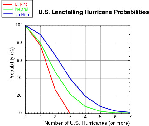
From this graph, the probability of 2 or more major hurricanes making landfall on the US coast is twice as great in La Niña years than it is in El Niño years. For more information, a link to the complete study is provided below.