


The Florida Climate Center serves as the primary resource for climate data, information, and services in the state of Florida.

The Florida Climate Center achieves its mission by providing climate monitoring, research, and expertise to be applied by the people, institutions, and businesses of Florida and the surrounding region.
We provide direct service by fulfilling requests for climate and weather data and information in a variety of formats.
We perform research that advances the understanding of the climate variability and changes of Florida and the surrounding region.
We provide outreach in presentations and at events aimed at a variety of groups, interests, and ages.
Prepared by Melissa Griffin and David F. Zierden
Florida Climate Center
The Florida State University
Tallahassee, FL

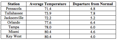
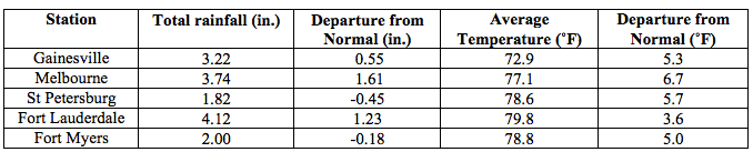
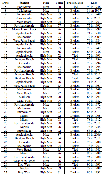
Average temperatures were well above normal across the state in April. Average temperatures in April 2015 were well above normal across the entire state, with departures ranging from 3.6˚F in Fort Lauderdale to 7.8˚F in Tallahassee (Table 1 and Appendix 1). No stations reported a minimum temperature below freezing (32˚F) during April and only a handful had one day with a minimum temperature at or below 40˚F for the month. Many locations across the state reported at least one day with a maximum temperature at or above 90˚F, and the station at Royal Palm, FL reported a temperature of 100˚F on the 26th. April 2015 was warmest on record for Fort Myers, Miami, Tallahassee and Tampa; the 2nd warmest in Key West and West Palm Beach; and the 5th warmest in Gainesville. At the time of this report, it was not yet determined if April 2015 was the warmest on record for the entire state. Multiple temperature records were tied or broken across the state in April (Appendix 2).
Table 1: April average temperatures and departures from normal (inches) for select cities.
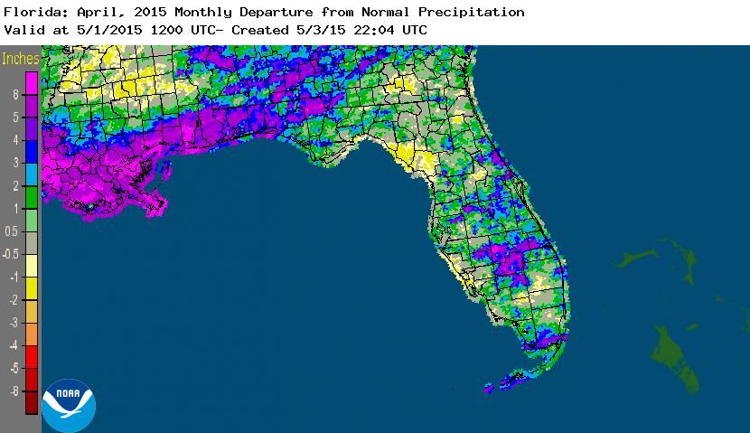
Rainfall totals were above normal across the state in April. With the exception of some areas along the West Coast, the entire state had rainfall totals above normal (Figure 1). Departures from normal roughly ranged from -0.45” to 5.66” (Table 2 and Appendix 1), though localized parts of the state saw rainfall totals that were as much as 2.00” below normal to 8.00” above normal (Figure 1). April 2015 was the 5th wettest on record at Key West, the 7th wettest in Orlando, and the 10th wettest for both Pensacola and Vero Beach. There were multiple 24-hour precipitation records broken for the month (Table 3).
Table 2: April precipitation totals and departures from normal (inches) for select cities.
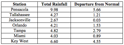
Table 3: Select daily rainfall records (inches) broken during April (compiled from NOAA, NWS).
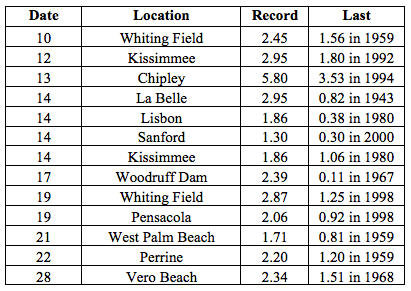
Figure 1: A graphical depiction of the monthly rainfall departure from normal (inches) for April is given in the figure below (courtesy of NOAA, NWS).
ENSO-neutral conditions continue in the Pacific.Based on current data and forecast models, the Climate Prediction Center (CPC) decided to continue the El Niño Advisory. Positive sea surface temperatures (SST) anomalies have been recorded across most of the Pacific Ocean. There is approximately a 70% chance that El Niño conditions will continue through the Summer 2015 and these conditions could persist into the fall. CPC predicts above normal temperatures and precipitation across the state through July 2015.
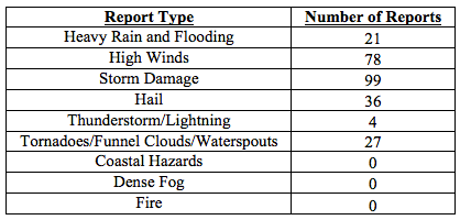
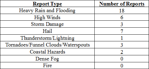
Hazardous weather events in April. There were a total of 265 severe weather reports made in Florida during April. On the 11th, a series of thunderstorms produced 45 mph wind gusts and heavy rain in and around the Orlando and Titusvillle areas. Heavy rain on the 12th caused problems in portions of the Panhandle. Reports of flooded roadways came in from Alford, Chipley, Cottondale, and Marianna. When the event ended in the early morning hours of the 13th, some locations in Jackson and Washington counties had received over 10.00” of rainfall. Later in the afternoon of the 13th, thunderstorms produced heavy rain and high winds, causing storm damage in Bunnell and Lake City, FL. In Macclenny, FL (Baker County), two people were injured due to a lightning strike; the same lightning strike started a structural fire. Lightning caused another structural fire on the 14th in Gulf Breeze, FL. On the 17th, multiple reports were made of waterspouts off the coast near Pompano Beach. A strong line of thunderstorms moved through the Panhandle on the 19th, causing storm damage, heavy rain, high winds and even a couple of tornadoes over the duration of the event. A short-lived EF-0 tornado moved through a rural area near Bruce, FL (Walton County); damage was confined to trees and a few power lines. The National Weather Service confirmed two EF-1 tornadoes, with wind speeds of 105 mph, near Ellaville, FL (Jackson County) and Tallahassee, FL after the survey of tree and structural damage was completed. As the line of storms continued to push across the Panhandle, storm damage reports came in from North Florida (Perry, Lake City, Gainesville, and Jacksonville) and Central Florida (Tampa, Orlando, Titusville, Cocoa Beach), where high winds (up to 60 mph) were recorded. On the morning of the 20th, over forty reports of storm damage (power outages and downed trees) were received from around the Tallahassee area as a line of storms moved through the city. As the line of thunderstorms pushed through the rest of the state, reports of hail (1.50” in diameter), storm damage and high winds (up to 60 mph) were reported in Bartow, Branford, Jacksonville, Jensen Beach, and Miami. Funnel clouds were seen over Boynton Beach and Miami Springs, and an EF-1 (winds 70-90 mph) tornado was confirmed southwest of Ocala. There were multiple reports of a waterspout that spawned over Lake Okeechobee and came ashore near Belle Glade, FL on the 23rd. April 25th was another active severe weather day across the northern part of state, as reports of hail, storm damage, heavy rain and strong winds were received from the Panhandle. An EF-1 tornado was confirmed in Arlington, FL (Duval County) with maximum winds speeds over 100 mph that caused damage to power lines and structures. Severe thunderstorms pushed through the southern Peninsula produced hail in locations on the north shore of Lake Okeechobee, along with areas around Stuart and Miami. At the end of the month, many reports of high winds were received from locations along the Keys.
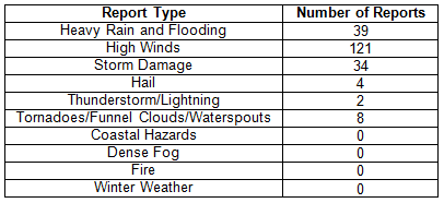
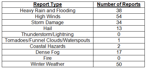
Table 4: Breakdown of storm reports submitted in Florida during April (compiled from Southeast Regional Climate Center).
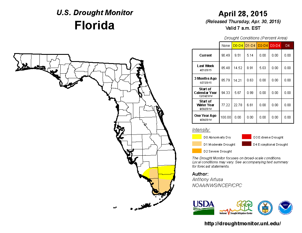
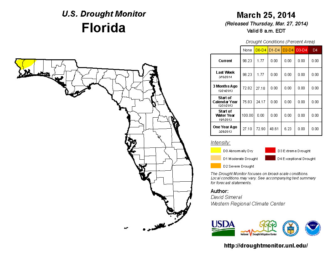
Drought Related impacts. At the end of March, nearly 24% of the state was experiencing abnormally dry (D0) conditions, with the main concentration of the dryness located in the western Panhandle and southern Florida. The lack of rainfall at the beginning of April led to the expansion of dry conditions (D0) into more of the Panhandle and Big Bend (Gadsden, Leon and Liberty counties), as well as South Florida (Collier, Glades, Hendry, Martin and Palm Beach counties). By the April 14th release of the Drought Monitor, localized heavy rains had eased dry conditions in the Panhandle with the removal of all moderate drought (D1) conditions, and even some D0 in Jackson, Walton and Washington counties. Around mid-month, additional rainfall in the Panhandle caused the complete removal of the remaining D0 conditions. However, the lack of rain in the southern part of the state caused the further expansion of D1 throughout the Everglades drainage basin. The area of severe drought (D2) conditions increased in size from roughly 1% of the state to 5%, to cover Collier, Dade, and Monroe counties. Based on data from the Drought Monitor, roughly 4.5 million Florida citizens are currently being impacted by drought conditions that are being reported in nearly 10% of the state. At the end of the month, the water level in Lake Okeechobee had dropped to under 14 ft., mainly due to regulatory releases.
Figure 2: Drought conditions in Florida as of April 28, 2015 (courtesy of U.S. Drought Monitor).
Appendix 1: Additional April departures from normal data for Florida locations.
Prepared by Melissa Griffin and David F. Zierden. Special thanks to L. Zuromski.
Florida Climate Center
The Florida State University
Tallahassee, FL
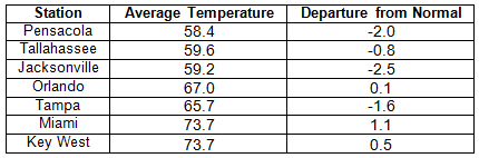
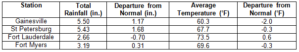
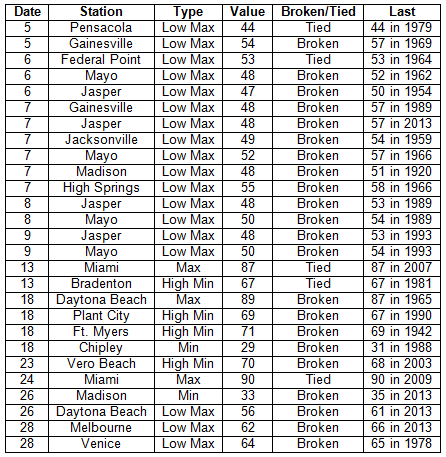
Average temperatures varied across the state in March. The departures for average temperatures in March 2014 varied across the entire state, ranging from -2.4˚F in Jacksonville to 1.1˚F in Miami (Table 1 and Appendix 1). Miami International Airport recorded 26 days with a maximum temperature above 80˚F, while Fort Myers and West Palm Beach each had 19 days above 80˚F. There were multiple maximum and high minimum temperatures that were broken or tied (Appendix 2).
Table 1: March average temperatures and departures from normal (°F) for selected cities.
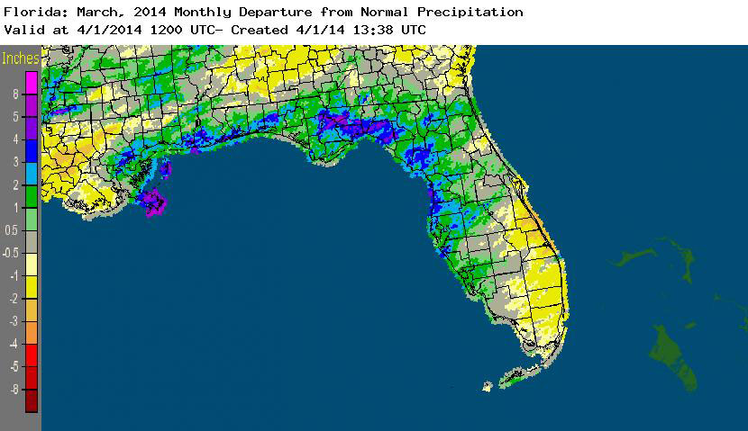
Rainfall totals varied across the state in March. Portions of the Big Bend and Panhandle reported monthly rainfall totals near average or slightly above normal, while totals in the rest of the state varied during March (Figure 1). Departures from normal roughly ranged from -0.70” to 4.29” (Table 2 and Appendix 1), though localized parts of Florida saw rainfall totals that were as much as 2.00” below normal to over 5.00” above normal. March 2014 was the 5th wettest on record at Pensacola, and 10th wettest at Key West. There were multiple 24-hour precipitation records broken for the month (Table 3).
Table 2: March precipitation totals and departures from normal (inches) for selected cities.
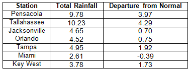
Table 3: Select daily rainfall records (inches) broken during March (compiled from NOAA, NWS).
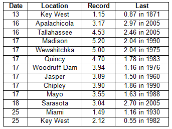
Figure 1: A graphical depiction of the monthly rainfall departure from normal (inches) for March is given in the figure below (courtesy of NOAA, NWS).
ENSO-neutral conditions continue in the Pacific. Based on current data and forecast models, the Climate Prediction Center (CPC) has issued an El Niño Watch. Though Neutral ENSO conditions continue to be reported, the equatorial sea surface temperatures (SSTs) were above average near the International Date Line, with regions of near average SST in the east-central Pacific. ENSO-neutral conditions are favored to continue through the spring of 2014, with a 50% chance of an El Niño forming in the summer or fall. CPC predicts above normal temperatures across the entire state and normal precipitation through June 2014.
Hazardous weather events in March. There were a total of 208 severe weather reports made in Florida during March. The month started out quiet, but, on the 5th, heavy rain around Jupiter, FL, caused flooding problems on local roadways. The following day, March 6th, a storm system caused multiple reports of waterspouts, wind gusts over 50 mph, storm damage, and even reports of tornadoes as it moved across portions of the state. Tornadoes were reported near Tampa and Belle Glade. High reports came in from Tampa, Fort Myers, Naples, Fort Lauderdale, Miami, and portions of the Florida Keys. A strong cold front caused heavy rain and flooding along the Panhandle and the Big Bend on the 16th; and lightning caused a house fire that destroyed a home in Hiland Park, FL (Bay County) on the same day. As the low pressure and associated cold front moved east, there were reports of heavy rain near Lake City and Jacksonville and high winds and numerous reports of storm damage across most of the Florida Peninsula on the 17th and 18th. Low pressure off the east coast on the 25th and the 26th caused high winds along portions of the Gold Coast and into the Keys. A squall line set up over Escambia County on the 28th and produced heavy rains, flooding, and storm damage as it moved through Pensacola to Fort Walton Beach, eventually impacting western portions of the Big Bend. On the 29th, the same area of disturbed weather that impacted north Florida the day before moved through the Peninsula. Reports of high winds (near 60 mph gusts), heavy rain, flooding, and hail (~1.25”) were made in Ocala, Tampa, Orlando, Lakeland, West Palm Beach, and Key West. There was a confirmed EF-0 tornado that hit near Lake Mary, FL (Orange County), causing minor damage to fences, small trees, and signs, and lighting caused a house fire in Lady Lake, FL (Lake County) on the 29th.
Table 4: Breakdown of storm reports submitted in Florida during March (compiled from Southeast Regional Climate Center).
Agricultural and other climate-related impacts. At the beginning of March, sugarcane mills in Palm Beach County were finishing their harvest, while farmers in other portions of the state readied fields for melon planting (Dixie and Gilchrist), replanted potatoes (Flagler and Putnam), prepped fields for planting corn (Walton), and harvested a variety of vegetables (Miami-Dade). Light rain fell over the citrus area, and field workers reported small sizes on all orange varieties. Bloom had been noted in the southern growing region, signaling the beginning of next year’s crop. Growers in Indian River were still dealing with a psyllid problem in groves. By the middle of the month, pasture quality across most of the state had improved due to the warmer temperatures and widespread rainfall. There were some portions of the state that received more than 2 inches of rain in a 24-hour period, and some fieldwork was impacted due to the heavy rains. Hay supplies were running short in a few counties, especially with some fields flooded from the rain. Daytime temperatures were unseasonably warm in the citrus growing area, and some groves began irrigating. Sugarcane harvest was nearing completion in the southern part of the state. Some farmers in the Panhandle were 2 weeks behind on preparing fields by the end of the month due to the heavy rains and flooded fields. Full bloom was evident in all areas on both oranges and grapefruits. The cattle condition for the state primarily ranged from fair to good, but the pasture condition was mostly fair.
Average rainfall across the state during March kept drought conditions under control, with only lingering dry conditions in the northwest Panhandle. Heavy rain events on the 17th and 25th of the month caused some rivers in the north and north-central part of the state to rise, causing minor flooding issues. The Climate Prediction Center is forecasting normal precipitation for April, May, and June, as the state enters the driest part of spring before transitioning to the rainy season in late May-early June.
Figure 2: Drought conditions in Florida as of March 24, 2014 (courtesy of U.S. Drought Monitor).
Appendix 1: Additional March departures from normal data for Florida locations.
Prepared by Melissa Griffin and David F. Zierden. Special thanks to L. Zuromski.
Florida Climate Center
The Florida State University
Tallahassee, FL
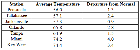
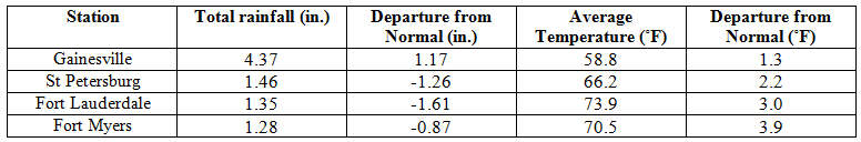
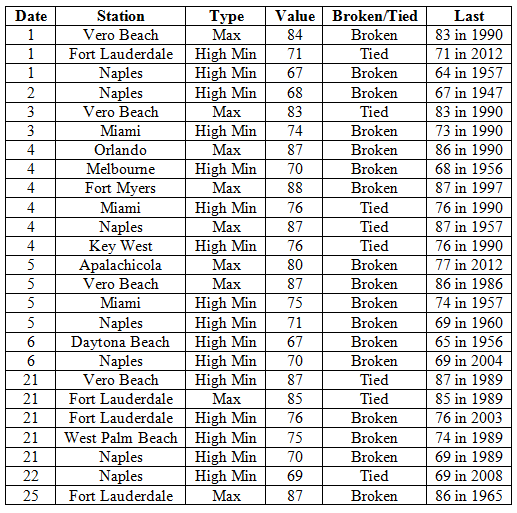
Average temperatures were above normal in February. In a complete turn around from cold of January 2014, the average temperatures for February 2014 were above normal across the entire state (Table 1 and Appendix 1). Departures from normal ranged from 0.9˚F in Jacksonville to 4.0˚F in Miami. The monthly average temperature for February 2014 was the 5th warmest in Miami, 7th warmest in West Palm Beach, and the 9th warmest in Vero Beach. Portions of the southeast coast saw more than 20 days with maximum temperatures above 80˚F and Naples recorded is warmest low temperature (71˚F) in the 1st two weeks of February since records started in 1942. There were multiple maximum and high minimum temperatures that were broken or tied (Appendix 2).
Table 1: February average temperatures and departures from normal (°F) for selected cities.
Rainfall totals varied across the state in February. Portions of the Big Bend and Panhandle, reported monthly rainfall totals near average or slightly above normal, while the rest of the state saw near to above average rainfall during February (Figure 1). Departures from normal roughly ranged from -1.61” to 2.82” (Table 2 and Appendix 1), though localized parts of Florida saw rainfall totals that were as much as 3.00” below normal to over 4.00” above normal. There was only one 24-hour precipitation record broken for the month (Table 3).
Table 2: February precipitation totals and departures from normal (inches) for selected cities.
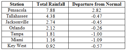
Table 3: Select daily rainfall records (inches) broken during February (compiled from NOAA, NWS).
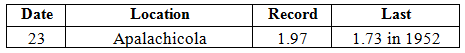
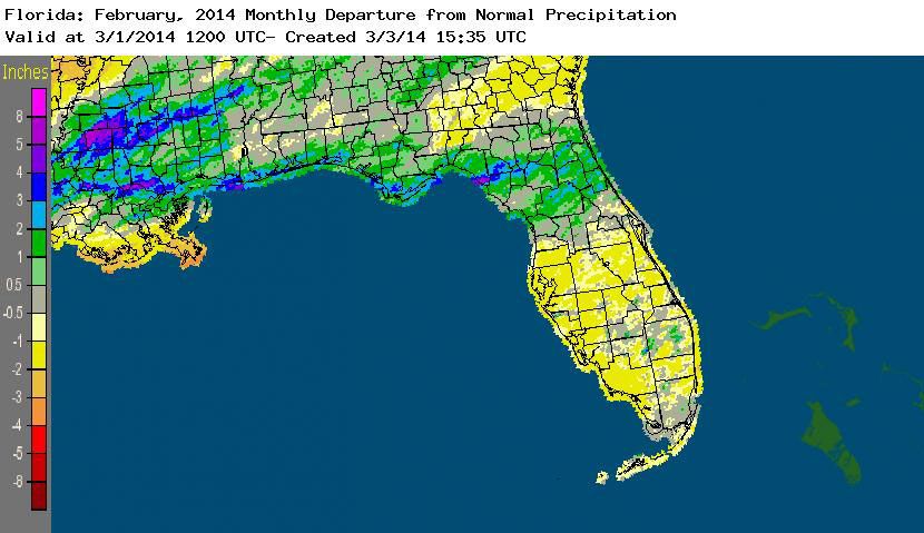
Figure 1: A graphical depiction of the monthly rainfall departure from normal (inches) for February is given in the figure below (courtesy of NOAA, NWS).
ENSO-neutral conditions continue in the Pacific. Neutral ENSO conditions continue to be reported for the equatorial Pacific with the equatorial sea surface temperatures (SST) above average across in the western Pacific, with regions of below average SST in the eastern Pacific. ENSO-neutral conditions are favored to continue through the spring of 2014, with a potential El Nino forming in the summer. The Climate Prediction Center (CPC) predicts above normal temperatures across the entire state and below normal precipitation for the Florida Panhandle through May.
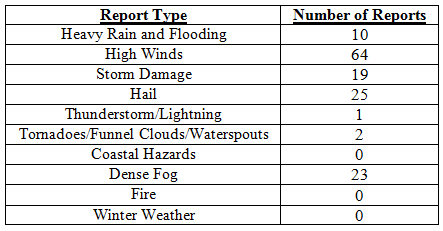
Hazardous weather events in February. There were 144 total severe weather reports were recorded in Florida for the month of February. The month started off with reports of dense fog on the 1st, 2nd and 3rd in portions of southern Florida. Areas south of Lake Okeechobee reported visibilities less than1/4 mile during the morning hours, impacting both inland and coastal communities. These same areas recorded dense fog on the morning of the 8th, with one report stating, “ Visibilities of 200-300 yards reported in Belle Glade.” A low-pressure system and associated stationary front on the 12t produced a line of thunderstorms that caused storm damage, with multiple reports of hail (pea to quarter sized), heavy rain high wind (up to 60 mph) as it pushed through the Peninsula. 73 storm reports came in from 15 counties on the 12th, with a report of a tornado in Fort Meade, FL that blew off a roof and porch of a structure, and lightning that started a house fire in Tampa, FL. A cold front raced through the northern part of the state on the 21st, producing high winds and hail along its path. There were multiple reports of trees and power lines down, with a report of an 18-wheeler being flipped over in Escambia County and a funnel cloud with 1” diameter hail in Putnam County. On the morning of the 23rd, an area of disturbed weather produced heavy rains, which caused flooding along portions of US 98 in Bay County, along with multiple reports of golf ball sized hail. Later on the 23rd, areas near Gainesville, Ocala, Daytona Beach and Orlando were impacted by hail and high winds from the same storm system.
Table 4: Breakdown of storm reports submitted in Florida during February (compiled from Southeast Regional Climate Center).
Agricultural and other climate-related impacts. The majority of the state saw temperatures that ranged from the upper 60s to the low 80s at the beginning of the month. The cold weather from the last week in January slowed the growth of winter wheat and caused a decline in the pasture conditions in northern parts of the state. The rain and foggy weather increased disease in vegetables, with reports of late blight being reported in tomatoes and potatoes. The citrus area received widespread rain and the active commercial groves in the state were drought free; but fruit sizes were still small on all varieties. Cloudy, cool wet conditions hampered fieldwork and crop growth by mid month. Various fruits and vegetables were marketed, while sugarcane and strawberries entered the last weeks of harvest. Citrus growers in Indian River experimented with tenting younger trees to help combat the psyllid population that had caused greening. The end of February saw farmers in Washington and Gadsden counties preparing ground for peanut and corn planting. Grover managers were reporting various sizes in the same blocks and have noticed blooms in several of the more southern citrus growing areas, signaling the beginning of next year’s crop. Citrus greening was still an issue and preventative measures were being taken to protect unaffected trees. Cattle conditions during the month were good, while pasture conditions were mostly fair; promoting cattlemen to feed hay and supplements.
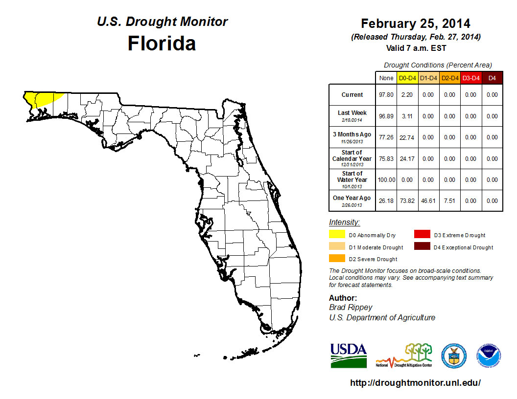
At the end of January nearly 30% of the state was characterized as dry, with the main concentration of the dryness (D0) confined to portions of the Space Coast and through the Okeechobee watershed into interior portions of the state to southwestern coast from Lee to Collier counties; and there was a small area of dryness reported in Escambia and Santa Rosa counties. Rains in the early part of the month eased most of D0 conditions in the Peninsula, with only Volusia, Seminole, Orange and Brevard counties showing dry conditions on the February 4th release of the Drought Monitor. By the 18th of the month, rainfall over portions of the east coast had led to an improvement of the lingering dry conditions and the only dry conditions left in the sate at the month’s end were those in the northwest Panhandle. The Climate Prediction Center is forecasting for precipitation to be below normal for March, April and May, in the Panhandle, while else where, precipitation is expected to be near normal as the state begins the transition in to the dry spring season.
Figure 2: Drought conditions in Florida as of February 25, 2014 (courtesy of U.S. Drought Monitor).
Appendix 1: Additional February departures from normal data for Florida locations.
Prepared by Melissa Griffin and David F. Zierden.
Florida Climate Center
The Florida State University
Tallahassee, FL
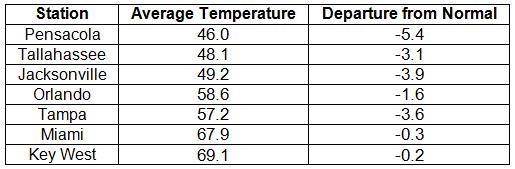
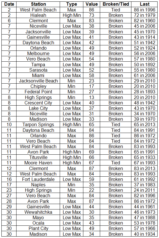
Average temperatures were below normal in January. The average temperatures for January 2014 were colder than normal across the entire state (Table 1 and Appendix 1). Departures from normal ranged from -0.2 ˚F in Key West to -5.4˚F in Pensacola. The monthly average temperatures for January 2014 were the 5th coldest in Madison and Pensacola, 7th coldest in Lake City, 8th coldest in Clermont, and 9th coldest in Gainesville, Inverness, and Orlando. On the 7th of January, a bitterly cold air mass pushed through the state, and locations north of Avon Park, with the exception of a few coastal stations, did not reach the 50˚F mark. Portions of the state, mainly in the Panhandle, did not get above 40˚F on the 29th. While there were a number of low maximum and minimum temperatures tied and broken during the month (121), there were also multiple maximum and high minimum temperatures that were broken or tied (Appendix 2).
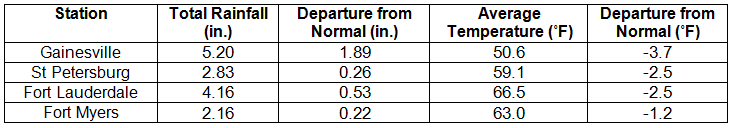
Table 1: January average temperatures and departures from normal (°F) for selected cities.
Rainfall totals varied across the state in January. Portions of the Big Bend and Panhandle reported monthly rainfall totals below normal, while the rest of the state saw near to above average rainfall during January (Figure 1). Departures from normal roughly ranged from -1.18” to 4.64” (Table 2 and Appendix 1), though some areas of Florida saw rainfall totals that were as much as 4.00” below normal to over 8.00” above normal. There was a report of 22.20” of rainfall measured in Hypoluxo on January 9 – 10 from torrential downpours associated with a stalled front over portions of the east coast. Totals across the area ranged from 10 to 15”. January 2014 was the wettest on record in Fort Pierce, 3rd wettest in Melbourne, 4th wettest in West Palm Beach, 6th wettest in Jacksonville and Key West, and 10th wettest in Gainesville and Miami. There was 1” of snow reported in Pensacola on the 28th. Numerous 24-hour precipitation records were broken for the month (Table 3).
Table 2: January precipitation totals and departures from normal (inches) for selected cities.
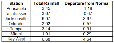
Table 3: Select daily rainfall records (inches) broken during January (compiled from NOAA, NWS).
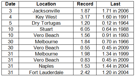
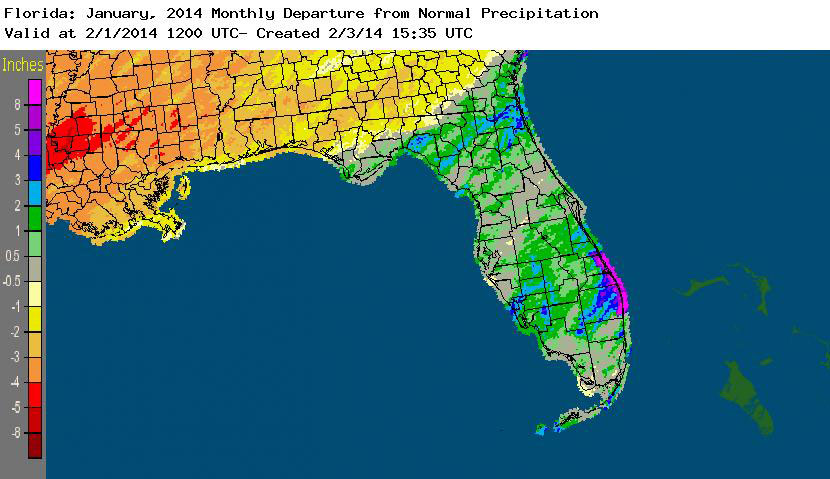
Figure 1: A graphical depiction of the monthly rainfall departure from normal (inches) for January is given in the figure below (courtesy of NOAA, NWS).
ENSO-neutral conditions continue in the Pacific. Neutral ENSO conditions continue to be reported for the equatorial Pacific, with the equatorial sea surface temperatures (SSTs) near average across much of the equatorial Pacific and regions of below average SSTs in the east-central Pacific. ENSO-neutral conditions are favored to continue through the summer of 2014. NOAA’s Climate Prediction Center (CPC) predicts above normal temperatures and below normal precipitation for the entire state through April.
Hazardous weather events in January. 209 severe weather reports were recorded in Florida for the month of January; 50 of those reports were for winter weather — something that does not happen often in the state. The month started off with dense fog reported on the southern shore of Lake Okeechobee, which reduced visibilities to less than ¼ mile. Also on the 2nd, heavy rain and high winds were seen along parts of the northeast coast. Reports of non-thunderstorm-based high winds came in along the Florida Keys from the 5th through the 7th. Localized flooding and heavy rain were reported from Boca Raton to Stuart, when a cold front ‘backed up’ and funneled tropical moisture over the area, producing heavy rain rates (~15.00” in 3 hours) on the 9th and 10th. On the 11th, multiple reports of storm damage and high winds were made as thunderstorms pushed through the Big Bend and north Florida. A storm on the 21st produced hail (pea to quarter sized) along its track from Normandy, FL, to Jacksonville. Widespread dense fog was reported on the mornings of both the 27th and 28th for areas south and southeast of Lake Okeechobee. The end of the month saw the first widespread winter weather events for the state in over a decade, as reports of freezing rain, sleet, and snow were made across the entire northern part of the state. Accumulating freezing rain caused Interstate 10 to be closed from the Florida/Alabama line to just east of Tallahassee. Many school districts, businesses, and government offices closed for ‘snow days’ from the 28th through the 30th due to the icy conditions.
Table 4: Breakdown of storm reports submitted in Florida during January (compiled from Southeast Regional Climate Center).
Agricultural and other climate-related impacts. Most of Florida reported rainfall and average temperatures at the beginning of January, which allowed for final harvesting of soybeans in the northern part of the state and the sugarcane to be processed without issue in Hendry, Palm Beach, and Glades counties. There was some frost and fungal damage to strawberries, collards, and turnips in Nassau County, and field workers were still reporting small sizes in all citrus varieties. The arctic air mass that impacted the state in early January did cause small damage to winter oats and contributed to pasture decline, while the winds associated with the cold front battered vegetable crops in Charlotte, Collier, Hendry, and Lee counties. Cold temperatures toward the end of the month caused some damage in cold-prone areas with frosted tops on plants, and there were losses in Bradford County due to frost and lower temperatures. Winter cover crops were being planted in the Panhandle. During the month, cattle and pasture conditions remained fair, though the prolonged dry conditions caused poor pasture conditions, and cattlemen used hay and supplements across the state to supplement forage.
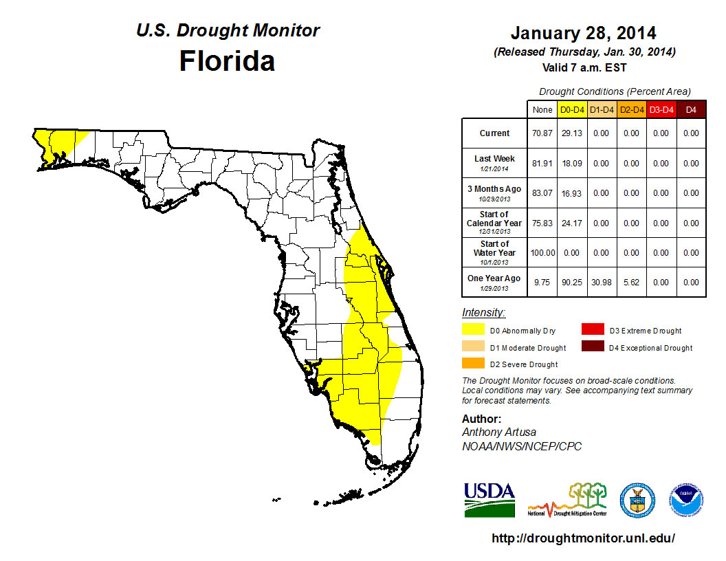
The beginning of 2014 saw dry conditions reported in 25% of the state, with the main concentration of the dryness (D0) confined to portions of the Space Coast and through the area of the state known as the Florida Heartland (DeSoto, Glades, Hardee, Hendry, Highlands, and Okeechobee) to Collier County. The residual dry conditions that were in northern Santa Rosa County and along the Florida-Georgia line near Jacksonville were removed after rainfall early in the month. Conditions remained consistent through most of January, although, by the end of the month, the area of dryness along the east coast and peninsula had expanded to cover more of the interior of the state. D0 was reintroduced into portions of Escambia and Santa Rosa counties in the Panhandle on the 28th. The Climate Prediction Center is forecasting below normal precipitation for February, March, and April, which could limit the amount of rain received by northern parts of the state during a critical recharge season.
Figure 2: Drought conditions in Florida as of January 28, 2014 (courtesy of U.S. Drought Monitor).
Appendix 1: Additional January departures from normal data for Florida locations.
Prepared by Melissa Griffin and David F. Zierden.
Florida Climate Center
The Florida State University
Tallahassee, FL
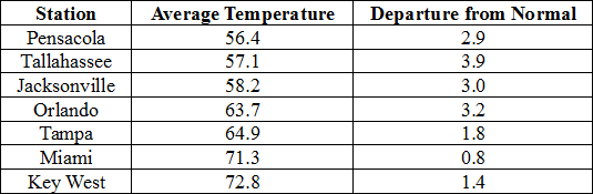
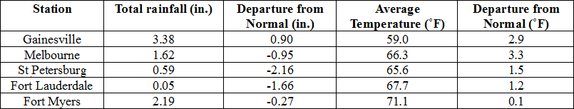
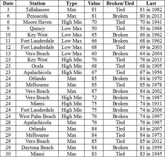
Average temperatures were above normal across the state in December. The departures for average temperatures in December 2014 for the Peninsula were above normal, though most of the reporting stations in the northern part of the state saw average temperatures well above normal. The departures ranged from 0.8˚F in Miami to 3.9˚F at Tallahassee. (Table 1 and Appendix 1). Despite the warm month, some stations in the Panhandle, Big Bend and North Florida recorded at least one day with a minimum temperature below freezing (32˚F) during the month; and no stations reported a maximum temperature over 90˚F. Multiple temperature records were tied or broken across the state in December (Appendix 2).
Table 1: December average temperatures and departures from normal (˚F) for selected cities.
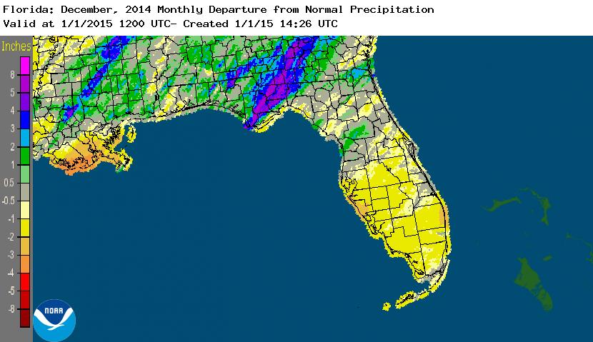
Rainfall totals varied across the state in December. A very localized portion of the Big Bend reported monthly rainfall totals well above normal, while the rest of Florida saw average rainfall during December near to below normal (Figure 1). Departures from normal roughly ranged from -2.16” to 4.88” (Table 2 and Appendix 1), though localized parts of Florida saw rainfall totals that were as much as 4.00” below normal to over 8.00” above normal (Figure 1). Tallahassee reported its wettest day in December since records started in 1892 on the 23rd when 7.44” of rainfall was recorded. 2014 was the 9th wettest year in Pensacola (83.17”) and the 10th wettest year in Daytona Beach (63.77”). There were multiple 24-hour precipitation records broken for the month (Table 3).
Table 2: December precipitation totals and departures from normal (inches) for selected cities.
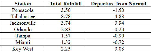
Table 3: Select daily rainfall records (inches) broken during December. (Compiled from NOAA, NWS)
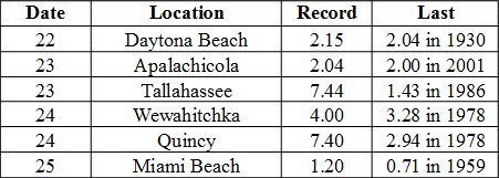
Figure 1: A graphical depiction of the monthly rainfall departure from normal (inches) for December is given in the figure below (courtesy of NOAA, NWS).
ENSO-Neutral Conditions Continue in the Pacific.
Based on current data and forecast models, the Climate Prediction Center (CPC) continue to have an El Niño Watch in place. Though Neutral ENSO conditions continue to be reported, positive sea surface temperatures (SST) anomalies have been recorded across most of the Pacific Ocean. An El Niño event is favored to develop during the Northern Hemisphere winter. CPC predicts below normal temperatures and above normal precipitation across the state through March 2015.
Hazardous Weather Events in December.
There were only 40 hazardous weather reports across the state in December. On December 8th, high winds (up to 50 mph) were reported along the eastern coast of Florida. High surf, up to 8 feet was reported around the area of St. Augustine and Vilano Beach. Waterspouts were reported offshore of Miami Beach, FL on the 13th. A lightning strike injured 11 people near Raymond James Stadium (Tampa, FL) on Dec 21st prior to a NFL Football game. Seven people were transported to the hospital, one of which was reported in critical condition, while four additional people went to the hospital on their own. A severe thunderstorm produced hail (pea to golf ball sized) in the Gainesville and Middleburg areas on the 22nd. On December 23rd, torrential heavy rains caused flooding in Tallahassee and Quincy, FL. Many roads in both locations were impassable due to standing water. In Defuniak Springs, a 10’ swath of water covered the southbound lanes of Highway 83, and floodwaters had closed roads in Walton County. After the front passed through, the combination of soggy ground and high winds caused trees to be knocked down in multiple Panhandle locations.
Table 4: Breakdown of storm reports submitted in Florida during the month of December (Compiled from Southeast Regional Climate Center.)
Agricultural and other climate related impacts.
At the beginning of December, cotton and soybean harvesting wrapped up in the Panhandle and north Florida. Farmers in the area began planting winter forage, oats and wheat for grain. The sugarcane harvest in Glades and Hendry counties continued, while vegetables harvesting in southwest Florida ramped up. Small amounts of rain and warmer weather improved pasture conditions and reduced cattle stress across portions of the state. Early orange harvest picked up significantly in the first part of the month, and the grapefruit harvest for both white and colored headed to plants for processing or to the fresh market. By mid-month, some U-pick strawberry fields had opened in Orange County, and spring vegetable planting began in Flagler and Putnam counties. Cattle and horse owners in southwest Florida were feeding hay to livestock, though pasture conditions were reported fair to good across Florida. Most of the early orange harvest was being used for juice and 13 out of 15 processing plants had opened and were beginning to run fruit. Heavy rains at the end of the month caused the fieldwork to be halted in the Panhandle, and the coldest temperature reported during that time was 34˚F in Walton County (Defuniak Springs). Sugarcane, strawberries, citrus, and vegetable harvests continued across the state. Harvesting totals for early oranges were down due to small sized fruits and the holidays. Citrus grove activity for the month included irrigation, mowing, aerial spraying, and fertilizing.
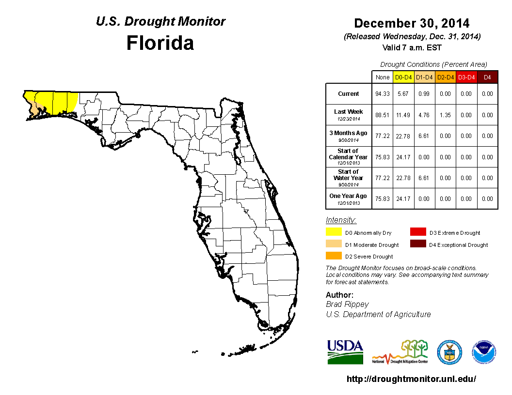
At the end of November, heavy rains across portions of the Panhandle and Big Bend reduced the moderate drought (D1) conditions to abnormally dry (D0) in Gadsden, Leon, Jefferson and Wakulla counties. Dry conditions over the first part of the month of December kept drought conditions consistent across the state. When the Drought Monitor was released on the 16th of the month, the D0 conditions were removed from Gadsden, Jefferson, Leon and Wakulla counties. Unfortunately, the rains that helped ease the drought conditions that had plagued that portion of the Big Bend for months did not help the northwestern Panhandle. The D0 conditions were seen in Bay, Holmes, Jackson and Washington counties, and D1 conditions expanded from the coastal area to interior portions of Escambia, Okaloosa and Santa Rosa counties. Severe drought (D2) was introduced in Escambia and Santa Rosa counties at mid-month. On December 23rd – 24th, a strong storm system moved through the northern part of the state, dumping 3.00” to 10.00” in the Panhandle and Big Bend. The rainfall caused localized flooding in some urbanized areas and some rivers and streams to rise. In addition, the rainfall reduced some of the drought impacts in the northwestern Panhandle counties. The remainder of the state saw monthly rainfall totals slightly below normal, though no drought conditions were posted during December.
Figure 2: Drought conditions in Florida as of December 31, 2014 (courtesy of U.S. Drought Monitor).
Appendix 1: Additional December Departures from Normal Data for Florida Locations
Appendix 2: Select daily maximum and minimum temperature records (o F) tied or broken during December. (Compiled from NOAA, NWS)
Building A, Suite 292
Tallahassee, FL 32306-2741
Phone: (850) 644-3417 | (850) 644-0719
climate@coaps.fsu.edu