


The Florida Climate Center serves as the primary resource for climate data, information, and services in the state of Florida.

The Florida Climate Center achieves its mission by providing climate monitoring, research, and expertise to be applied by the people, institutions, and businesses of Florida and the surrounding region.
We provide direct service by fulfilling requests for climate and weather data and information in a variety of formats.
We perform research that advances the understanding of the climate variability and changes of Florida and the surrounding region.
We provide outreach in presentations and at events aimed at a variety of groups, interests, and ages.
Prepared by Daniel J. Brouillette
Florida Climate Center
The Florida State University
Tallahassee, FL

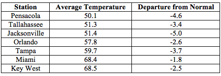
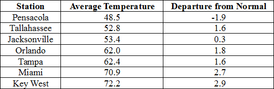
Mean temperatures in November ranged from much above normal on the Keys to somewhat above normal on the peninsula to somewhat below normal on the panhandle (Table 1 and Appendix 1). It was the second-warmest November at Key West. Several high temperature records were tied or broken across the state (Appendix 2).
Table 1. November average temperatures and departures from normal (˚F) for selected cities.
| Station | Mean Temperature | Departure from Normal |
| Pensacola | 59.1 | -1.6 |
| Tallahassee | 59.2 | -1.0 |
| Jacksonville | 63.3 | +0.9 |
| Orlando | 69.8 | +1.3 |
| Tampa | 70.7 | +1.6 |
| Miami | 75.8 | +0.8 |
| Key West | 79.8 | +4.0 |
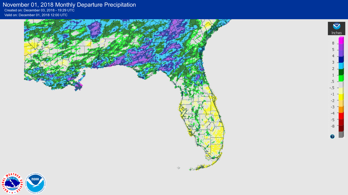
Rainfall totals in November were above normal in north and parts of central Florida and near to below normal south of those areas (Figure 1). (Table 3).
Table 2. November precipitation totals and departures from normal (inches) for selected cities.
| Station | Total Rainfall | Departure from Normal |
| Pensacola | 5.62 | +0.89 |
| Tallahassee | 5.28 | +1.78 |
| Jacksonville | 5.21 | +3.00 |
| Orlando | 2.21 | +0.04 |
| Tampa | 0.63 | -0.92 |
| Miami | 2.77 | -0.50 |
| Key West | 1.21 | -1.09 |
Table 3. Select daily rainfall records (inches) broken during November. (Compiled from NOAA, NWS)
Figure 1. A graphical depiction of the monthly rainfall departure from normal (inches) for November is given in the figure below (courtesy of NOAA, NWS).
ENSO-neutral conditions are present in the Pacific, with El Niño to develop.
Based on current data and forecast models, forecasters with the Climate Prediction Center (CPC) continue with an El Niño Watch. ENSO-neutral conditions currently are present, with sea-surface temperatures (SST) above average across the equatorial Pacific Ocean. El Niño is expected to develop, continuing through boreal winter (~80% chance) and possibly into the boreal spring (55-60% chance). The CPC seasonal outlook favors above-normal temperatures statewide and above-normal rainfall statewide, especially on the panhandle, in December 2018.
Hazardous Weather Events in November.
According the Local Storm Reports (LSRs) issued by the local National Weather Service (NWS) offices serving Florida, 92 instances of hazardous weather were reported across the state in November 2018.
Table 4. Breakdown of storm reports submitted in Florida during the month of November. (Compiled from Iowa State University/Iowa Environmental Mesonet.)
| Report Type | Number of Reports |
| Storm Damage | 12 |
| High Winds | 44 |
| Dense Fog | 6 |
| Hail | 2 |
| Tornadoes/Funnel Clouds/Waterspouts | 18 |
| Heavy Rain | 9 |
| Fire | 1 |
| Flooding | 0 (excluding storm surge/coastal) |
| Lightning | 1 |
| Heat | 0 |
| Coastal Hazards/Rip Currents | 0 |
Drought-Related Impacts
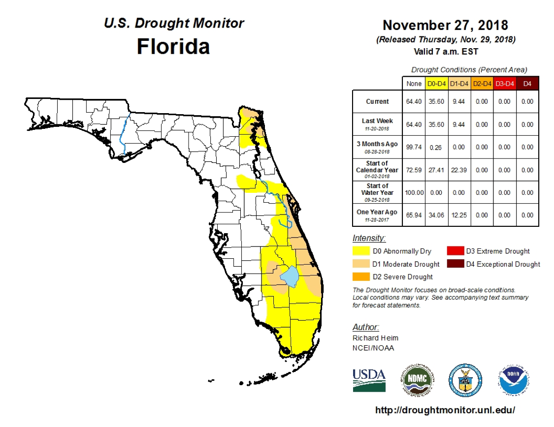
At the end of November, according to the U.S. Drought Monitor, abnormally dry conditions were present over much of the eastern half of the peninsula, with moderate-drought conditions found in the far northeast, along the central Atlantic coast, and on the west side of Lake Okeechobee. However, it is noted that November begins the dry season on the peninsula.
As of 3 December, the Lake Okeechobee water level was at 13.03 ft. above sea level, which is a bit below average for this time of the year.
Agriculture-Related Impacts.
At the end of November, top-soil moisture was adequate over half the state, short or very short over about one-third, and at surplus over the balance. The first frost or freeze had occurred during the month as far south as north-central Florida. Citrus harvest was underway, but progress was behind what is was last year at this time. Pasture quality was seeing decline late in the month in the north because of cool, wet conditions and in the south because of drier conditions. Nonetheless, cattle condition remained good. Frequent rain in the panhandle hindered the cotton harvest. Most peanuts have been harvested, but some remained in Jackson and Holmes counties at the end of the month.
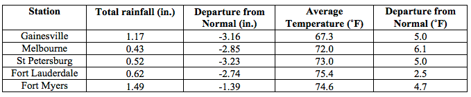
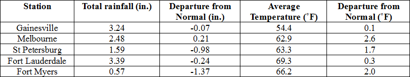
Appendix 1
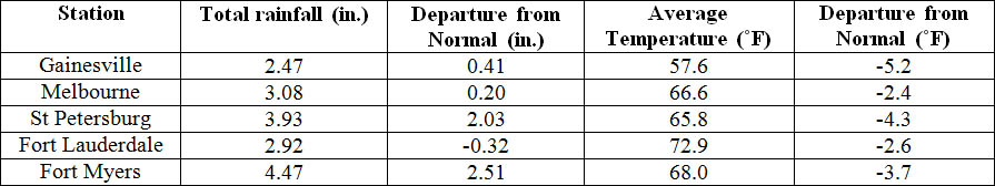
Additional November Departures from Normal Data for Florida Locations
| Station | Total rainfall (in.) | Departure from Normal (in.) | Average Temperature (˚F) | Departure from Normal (˚F) |
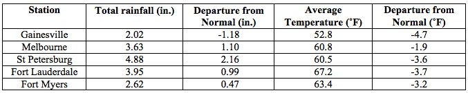
| Gainesville | 2.81 | +0.75 | 64.2 | +1.5 |
| Melbourne | 1.16 | -1.72 | 71.4 | +2.4 |
| Fort Lauderdale | 2.60 | -0.64 | 75.9 | +0.4 |
| Fort Myers | 1.50 | -0.46 | 73.1 | +1.5 |
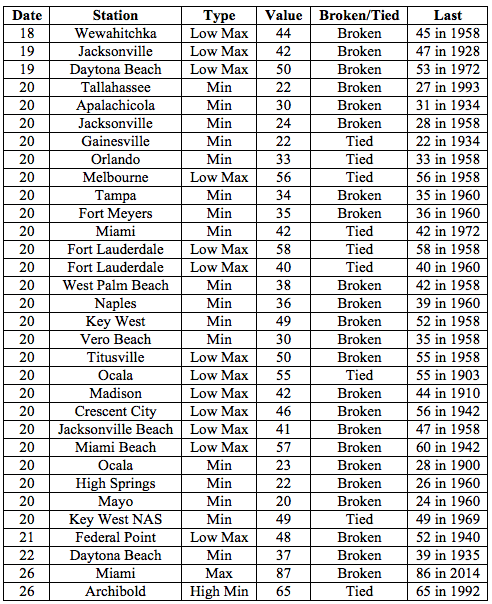
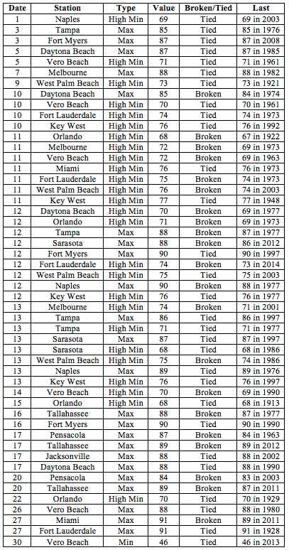
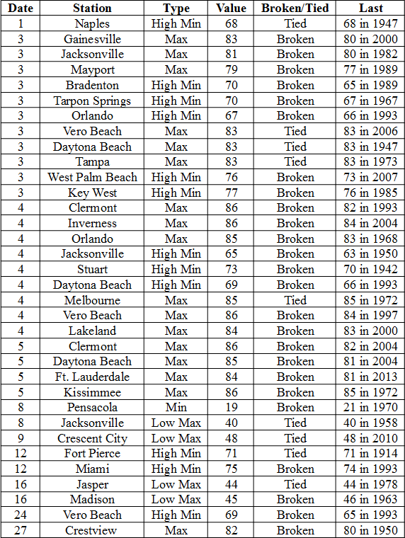
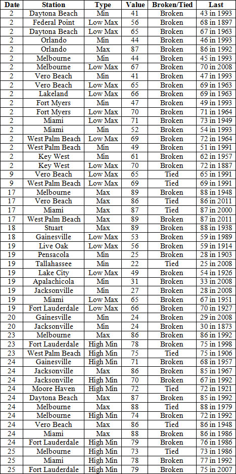
Appendix 2
Select daily maximum and minimum temperature records (oF) tied or broken during November.
(Compiled from NOAA, NWS)
| Date | Station | Type | Value | Broken/Tied | Last |
| 6 | Jacksonville | Max | 88 | Broken | 86 in 2003 |
| 13 | Jacksonville | Max | 87 | Broken | 86 in 1889 |
| 14 | Orlando | Max | 88 | Tied | 88 in 2008 |
| 14 | Orlando | High Min | 71 | Broken | 70 in 2008 |
| 13 | Tampa | High Min | 75 | Broken | 74 in 2008 |
| 14 | Tampa | High Min | 73 | Tied | 73 in 2008 |
| 4 | Key West | Max | 88 | Broken | 87 in 2015 |
| 6 | Key West | Max | 88 | Tied | 88 in 1880 |
| 8 | Key West | Max | 87 | Tied | 87 in 1955 |
| 10 | Key West | Max | 87 | Tied | 87 in 1987 |
| 12 | Key West | High Min | 80 | Tied | 80 in 2002 |
| 14 | Key West | Max | 87 | Broken | 86 in 1949 |
| 14 | Key West | High Min | 81* | Broken | 79 in 1993 |
| 26 | Key West | High Min | 78 | Tied | 78 in 1986 |
*This value ties the all-time highest minimum temperature ever recorded at Key West for the month of November (records back to 1872); the last occurrence was on 9 November 2015.
Prepared by Melissa Griffin and David F. Zierden.
Florida Climate Center
The Florida State University
Tallahassee, FL
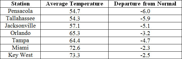
Average temperatures were below normal across the state in February. The departures for average temperatures in February 2015 were below normal across the entire state, with departures ranging from -1.8˚F in Miami to -5.0˚F at Jacksonville. (Table 1 and Appendix 1). Most stations in the Panhandle, Big Bend and North Florida recorded at least one day with a minimum temperature below freezing (32˚F) during February, and a few locations as far south as La Belle, FL reported a day below freezing on the 20th. February 2015 was the 9th coldest on record in Gainesville. Multiple temperature records were tied or broken across the state in January (Appendix 2).
Table 1: February average temperatures and departures from normal (˚F) for selected cities.
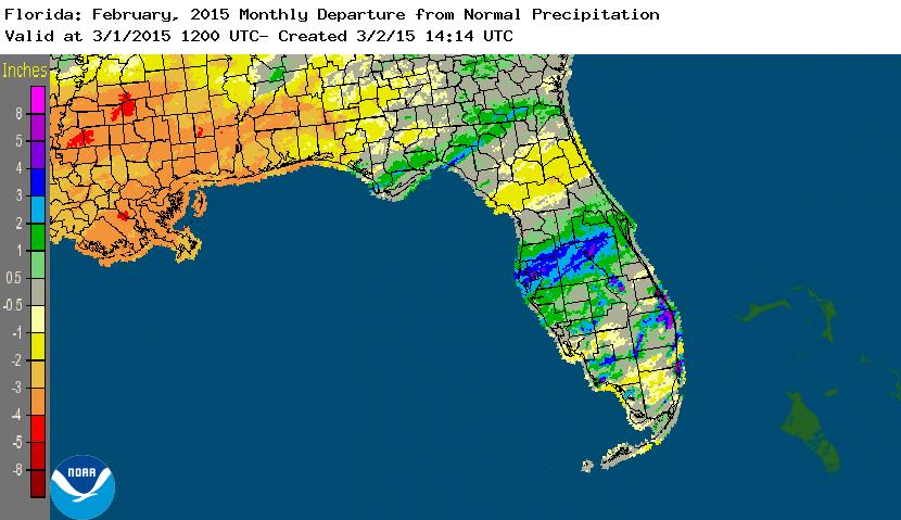
Rainfall totals were varied across the state in February. Most of the western Panhandle and the northern Peninsula saw below normal rainfall during February, while portions of the Big Bend, Central Florida and the East Coast had rainfall totals above normal (Figure 1). Departures from normal roughly ranged from -1.18” to 3.74” (Table 2 and Appendix 1), though localized parts of state saw rainfall totals that were as much as 4.00” below normal to over 5.00” above normal (Figure 1). February 2015 was the 7th wettest on record in Tampa and Orlando, the 9th wettest for Plant City and the 10th wettest in Hialeah. A significant rain event took place in the Broward and Dade counties on the 28th, where some locations along the coast picked up over 5.00” of rain. There were multiple 24-hour precipitation records broken for the month (Table 3).
Table 2: February precipitation totals and departures from normal (inches) for selected cities.
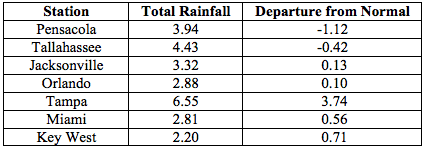
Table 3: Select daily rainfall records (inches) broken during February. (Compiled from NOAA, NWS)
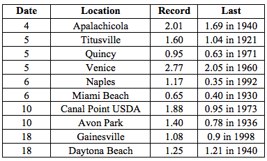
Figure 1: A graphical depiction of the monthly rainfall departure from normal (inches) for February is given in the figure below (courtesy of NOAA, NWS)
ENSO-Neutral Conditions Continue in the Pacific.
Based on current data and forecast models, the Climate Prediction Center (CPC) continues to have an El Niño Watch in place. Positive sea surface temperatures (SST) anomalies have been recorded across the western and central Pacific Ocean, while near average SSTs are evident in the eastern Pacific. There is still a 50% chance of an El Niño event developing within the late winter/early spring. After the Northern Hemisphere winter, a return to ENSO-Neutral conditions is favored. CPC predicts normal temperatures and above normal precipitation across the state through May 2015.
Hazardous Weather Events in February.
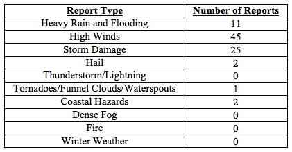
There were a total of 86 severe weather reports made in Florida during February. On the 5th, a tornado made two touchdowns in the Boca Raton area. The first touchdown was rated as an EF-1, and the second was rated as an EF-0. Several trees were uprooted or snapped in half, and a home sustained damage from a projectile tree limb that punctured its roof. High winds, up to 60 mph, and additional storm damage were reported on the same day in Boynton Beach, Delray Beach, and along the Florida Keys. The tidal gauges near Fernandina Beach and Mayport recorded astronomical low tides (-6.13 and -4.92 ft.) on the 19th, due to a ‘blow-out’ after the passage of a strong cold front on the morning of the 19th. The same cold front caused high winds, up to 50 mph, along many locations in the Keys. A developing low-pressure system and associated warm front caused severe weather in the Big Bend during the 25th and 26th. Multiple reports of strong winds, downed trees and power lines, and damage to structures were reported from locations in and around Panama City Beach, Tallahassee, Lake City, Jacksonville, Gainesville, and Tampa. At the end of the month, a stationary front over South Florida brought heavy rains and flooding from Port St. Lucie to Miami, with a few places reporting nearly 10” of rain. There were reports of dime and pea-sized hail in Kissimmee and at the FAU Campus on the 28th.
Table 4: Breakdown of storm reports submitted in Florida during the month of February. (Compiled from Southeast Regional Climate Center.)
Agricultural and other climate related impacts.
At the beginning of February, soil moisture continued to be mostly adequate in the Panhandle and northern Florida from rains in January. Blueberry bushes showed signs of early blooming in Marion County, and harvesting of fruits and winter vegetables continued across the state. Pasture and cattle conditions in South Florida were in decline and producers were providing supplemental feed as necessary. Fieldwork and soil preparation for the spring plantings continued in the Panhandle. Excess water from early February rains was being pumped out of fields in locations across central Florida, especially in Brevard County. Some pastures were in poor conditions due to standing water, and farmers in Orange and Seminole counties were having problems locating hay for their cattle. Toward the middle of the month, citrus growers were noticing some bloom, mostly on early variety fruit, and new growth was seen on well-maintained trees. Growth of cool-season forage crops slowed due to cold weather and frost across northern Florida and parts of the Peninsula. Sub-freezing temperatures caused damage to the tops of some vegetables plants with most extensive damage was to corn and bean and blueberries were damaged by the frost. The windy weather that preceded the freeze battered sensitive vegetable crops, causing minimal damage. Most of the citrus processing plants were up and running, though most of the plants plan on finishing early and midseason oranges by the end of February.
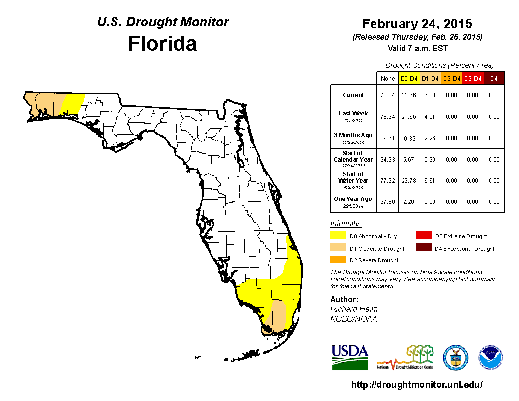
February started off with nearly 14% of the state reporting abnormally dry (D0) conditions, with the main concentration of the dryness located in the western Panhandle and southern Florida. Widespread rainfall impacted the state on the 5th and 6th of February, but the dry start to the month exacerbated conditions in the southern part of the state, and D0 was added to all of Broward and Collier counties and extended along coastal Indian River and St. Lucie counties. Another storm system brought rain to the Panhandle on the 17th and 18th, however near the end of the month, moderate drought (D1) conditions were introduced in portions of Miami-Dade and Monroe counties, especially in the Everglades National Park. The lack of rainfall throughout the month caused the expansion of existing D1 in Escambia County into all of Santa Rosa and western portions Okaloosa counties in the Panhandle. At the end of the month, the water level in Lake Okeechobee had dropped to under 15 ft., mainly due to regulatory releases. Heavy rains in portions of Alabama and Georgia caused rivers in northern Florida to rise, with some minor flooding along the Choctawhatchee, Apalachicola, Ochlockonee, and Withlacoochee.
Appendix 1: Additional February Departures from Normal Data for Florida Locations
Appendix 2: Select daily maximum and minimum temperature records (o F) tied or broken during February (Compiled from NOAA, NWS)
Prepared by Melissa Griffin and David F. Zierden.
Florida Climate Center
The Florida State University
Tallahassee, FL
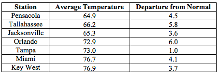
Average temperatures were well above normal across the state in March. The departures for average temperatures in March 2015 were well above normal across the entire state, with departures ranging from 1.0˚F in Tampa to 6.1˚F in Melbourne. (Table 1 and Appendix 1). Pensacola, FL reported only one day with a minimum temperature below freezing (32˚F) during March and many locations in southern Florida (such as Fort Myers, Miami, and West Palm Beach) reported at least one day with a maximum temperature at or above 90˚F. March 2015 was the 2nd warmest in Fort Myers, Miami and West Palm Beach; 3rd warmest in Orlando; 4th warmest in Ocala, Tampa and Vero Beach; and 10th warmest in Key West and Tallahassee. Multiple temperature records were tied or broken across the state in March (Appendix 2).
Table 1: March average temperatures and departures from normal (˚F) for selected cities.
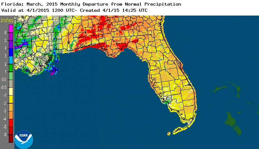
Rainfall totals were well below normal across the state in March. With the exception of Lee County, FL, the entire state had rainfall totals below normal (Figure 1). Departures from normal roughly ranged from -0.57” to -3.43” (Table 2 and Appendix 1), though localized parts of state saw rainfall totals that were as much as 5.00” below normal (Figure 1). March 2015 was the 9th driest March on record for Daytona Beach. A significant rain event took place in Walton, Okaloosa, and Washington counties on the 22nd, where some locations along the coast picked up over 5.00” of rain. Despite the fact that rainfall totals across the state were below normal, there were multiple 24-hour precipitation records broken for the month (Table 3).
Table 2: March precipitation totals and departures from normal (inches) for selected cities.
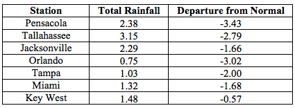
Table 3: Select daily rainfall records (inches) broken during March. (Compiled from NOAA, NWS)
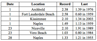
Figure 1: A graphical depiction of the monthly rainfall departure from normal (inches) for March is given in the figure below (courtesy of NOAA, NWS)
ENSO-Neutral Conditions Continue in the Pacific.
Based on current data and forecast models, the Climate Prediction Center (CPC) has downgraded the previous El Niño Watch to an El Niño Advisory. Positive sea surface temperatures (SST) anomalies have been recorded across most of the Pacific Ocean. There is still a 50% chance that El Niño conditions will continue through the summer. CPC predicts normal temperatures and above normal precipitation across the state through June 2015.
Hazardous Weather Events in March.
There were a total of 76 severe weather reports made in Florida during March. On the 11th, a thunderstorm produced 45 mph wind gusts that were reported in Orange Park, FL. The same line of thunderstorms also caused damage in Crescent City, FL, as reports of power outages and downed trees came from numerous points across town. A 17-year-old male lost his life on the 14th when he became trapped in a rip current in the waters at Jaycee Beach, FL. A pilot reported several waterspouts, roughly 30 miles off the coast of Palm Beach Shores, FL on the 19th. Nearly 5.00” of heavy rain fell in Portland, FL (Walton County) as part of a localized rain event that impacted portions of Walton, Okaloosa, and Washington counties on the 22nd. The following day (23rd), multiple reports of dime-sized hail were made from the Flagler Beach area. March 26th and 27th were very active severe weather days across the state as a strong cold front moved through the state. Lightning struck a tree, which smoldered and eventually caught a house on fire in Mulberry, FL on the 26th. The same day, wind gusts of 50 mph were recorded in Lake City and Fort Pierce; and storm damage (in the form of downed trees) accompanied these reports. Hail, quarter to half dollar sized, fell in the same locations, and multiple reports of a waterspout came in from Jensen Beach, FL. Thunderstorms raced through the state on the 27th, producing wind gusts of up to 60 mph in the following locations: Titusville, Orlando, Kissimmee, Naples, West Palm Beach, Fort Lauderdale, Miami, Beach, Miami, and the Keys. Quarter-sized hail was reported in Altha, FL on the 30th and a funnel cloud was seen near the Lion Country Safari in Palm Beach County on the 31st.
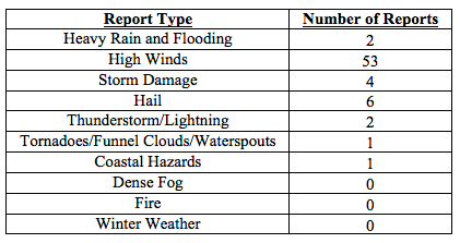
Table 4: Breakdown of storm reports submitted in Florida during the month of March. (Compiled from Southeast Regional Climate Center.)
Agricultural and other climate related impacts.
At the beginning of March, the cold weather and saturated soil from the rains at the end of February were evident in the Panhandle. Sub-freezing temperatures caused concern for crops in northern parts of the state. Sugarcane harvesting continued on schedule in Glades and Hendry counties, while potato planting took place in Flagler, Putnam, and St. Johns counties. Poor pasture qualities across the state, and lack of hay and winter forage, impacted livestock conditions throughout Florida, and ranchers fertilized pastures to try and revitalize them. Many of the citrus processing plants had finished early and midseason oranges and had transitioned to harvesting late-season oranges and grapefruits by the middle of the month. Corn was planted in Washington, Madison, and Suwannee counties, and preparations for cotton and peanuts began in many Panhandle counties. By the middle of March, the warmer weather and longer days boosted pasture growth in the Panhandle, and northern and central Florida. Southwest pasture conditions declined due to the dry conditions and ranchers used supplemental feed for livestock. Valencia harvest increased but weekly totals were behind last season due to low maturity levels. Most grove owners were irrigated two to three times a week and applying herbicide. Citrus trees were in full bloom by the end of the month, with petal drop and small pea-sized fruit reported on early variety trees.
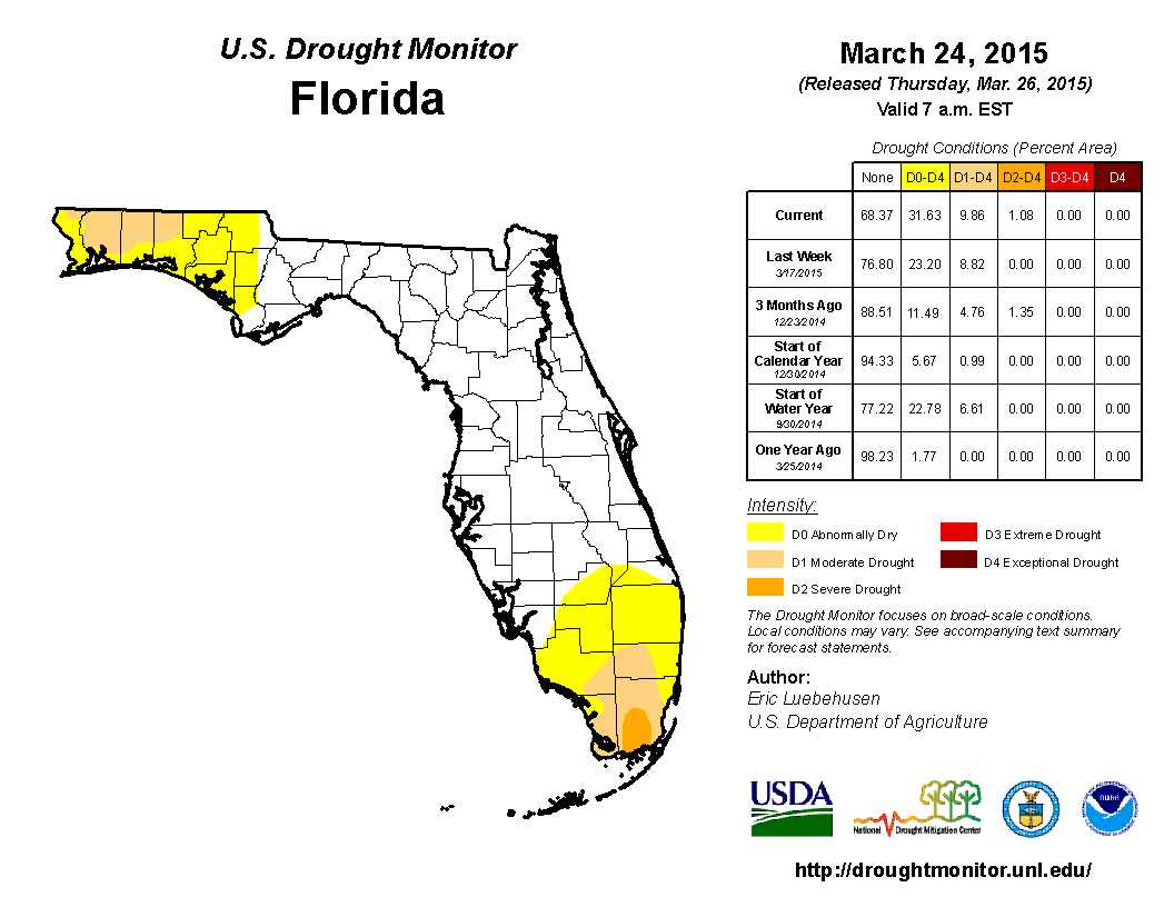
At the end of February, nearly 22% of the state was experiencing abnormally dry (D0) conditions, with the main concentration of the dryness located in the western Panhandle and southern Florida. Light widespread rainfall was seen over the Panhandle and North Florida on the 6th, while spotty shower activity was seen in South Florida from the 7th through the 9th. The rainfall over the area prompted the removal of D0 from most of Palm Beach County and portions of Collier County at the beginning of March. During the middle of the month, light and spotty rainfall was seen across the Panhandle and Peninsula, with some localized areas seeing up to 1.50” rainfall. When the drought monitor was released on the 17th, there had been an expansion of the D0 conditions in the Panhandle to include Holmes, Washington, Jackson, Bay, Gulf, and Calhoun counties. On the 23rd, a heavy band of rainfall (up to 5.00”) in coastal portions of the Panhandle counties, and on the 24th, rainfall up to 2.00” was seen in some of the Central Florida counties. By the time the last drought monitor map was released for the month, D0 had been expanded in South Florida to include Palm Beach, Glades, and Martin counties. Moderate drought conditions (D1) were also expanded within Collier and Dade counties, and severe drought conditions (D2) had been introduced into southern portions of Dade County. Based on data, roughly 3.5 million Florida citizens are currently being impacted by drought conditions that are being reported in nearly 32% of the state. At the end of the month, the water level in Lake Okeechobee had dropped to under 14 ft., mainly due to regulatory releases.
Appendix 1: Additional March Departures from Normal Data for Florida Locations
Appendix 2: Select daily maximum and minimum temperature records (o F) tied or broken during March. (Compiled from NOAA, NWS)
Prepared by Melissa Griffin and David F. Zierden.
Florida Climate Center
The Florida State University
Tallahassee, FL
Average temperatures were varied cross the state in January. The departures for average temperatures in January 2015 varied across the entire state, though most of the reporting stations saw average temperatures above normal. The departures ranged from 2.9˚F in Key West to -1.9˚F at Pensacola. (Table 1 and Appendix 1). Most stations in the Panhandle, Big Bend and North Florida recorded at least one day with a minimum temperature below freezing (32˚F) during the January. Despite most of the above normal temperatures, none of reporting stations had values that were ranked with in the top 10 for the month. Multiple temperature records were tied or broken across the state in January (Appendix 2).
Table 1: January average temperatures and departures from normal (˚F) for selected cities.
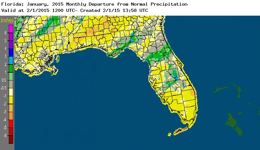
Rainfall totals were below normal across most of the state in January. With the exception of a small portion of the Big Bend, and areas in north Central Florida and the interior Peninsula, most of Florida saw below average rainfall during January (Figure 1). Departures from normal roughly ranged from -1.76” to 1.17” (Table 2 and Appendix 1), though localized parts of state saw rainfall totals that were as much as 4.00” below normal to over 3.00” above normal (Figure 1). The last three months (November – January) have been the 4th wettest on record in Ocala, the 6th wettest for both Daytona Beach and Tallahassee and the 12th wettest in Orlando. A trace of snow was reported in Jacksonville on the 8th. There were multiple 24-hour precipitation records broken for the month (Table 3).
Table 2: January precipitation totals and departures from normal (inches) for selected cities.
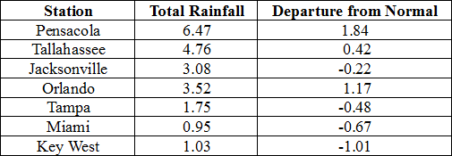
Table 3: Select daily rainfall records (inches) broken during January. (Compiled from NOAA, NWS)
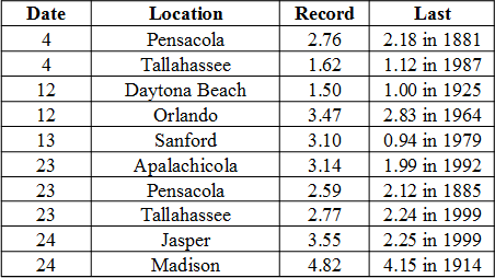
Figure 1: A graphical depiction of the monthly rainfall departure from normal (inches) for January is given in the figure below (courtesy of NOAA, NWS)
ENSO-Neutral Conditions Continue in the Pacific.
Based on current data and forecast models, the Climate Prediction Center (CPC) continue to have an El Niño Watch in place. Positive sea surface temperatures (SST) anomalies have been recorded across most of the Pacific Ocean and there is a 50% chance of an El Niño event developing within the next two months. After the Northern Hemisphere winter, a return to ENSO-Neutral conditions is favored. CPC predicts normal temperatures and precipitation across the state through April 2015.
Hazardous Weather Events in January.
There were a total of 61 severe weather reports made in Florida during January. It was a quiet month, in terms of severe weather, and only a few events caused hazardous weather across the state. Strong winds up to 50 mph were reported in various locations on the East Coast on the 8th, ahead of a cold front that moved through the state. On the same day, snow was spotted around the Jacksonville area, including at the Jacksonville International Airport. A waterspout was reported off the coast near Juno Beach on the 9th and was photographed by a number of the public. A CoCoRaHS observer recorded 3.57” of rain in 13 hours in St. Augustine in 12th. Most of the severe weather reports came from a vigorous low-pressure system that moved through the state on the 23rd – 24th. Heavy rains were reported in most of the Big Bend, including Bay, Liberty, Franklin, Wakulla, Leon, Jefferson and Madison counties. The heavy rains caused local rivers to rapidly rise and promoted flood warnings in some local areas On the 24th, the Florida State Watch in Myakka State Forest reported damage to a ranger station and residence that was associated with a tornado near Englewood (Sarasota County). Many locations in north Florida, such as St George Island, Apalachicola, Jacksonville and St. Augustine, saw wind gusts up to 50 mph as the front associated with the system pushed through the area. On the 26th, high winds up to 45 mph were recorded in Naples, Boca Raton, Miami and Key Largo.
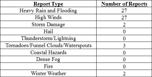
Table 4: Breakdown of storm reports submitted in Florida during the month of January. (Compiled from Southeast Regional Climate Center.)
Agricultural and other climate related impacts.
At the beginning of January, soil moisture in the Panhandle was very high, but was seen short in other areas of the state. Pasture conditions in the northern part of the state improved due to the warmer weather and some of the rainfall. The sugarcane harvest continued in Glades and Hendry counties, and farmers started harvesting cabbage and cold weather crops in Flagler, Bradford and Putnam counties. Growers in southwest Florida began planting watermelons and spring vegetables and south Florida crops had to be irrigated. Some foggy mornings caused disease problems with vegetables in southwest Florida around mid-month, and heavy rains in the Panhandle and Big Bend caused problems with pasture conditions and field preparation. All of the citrus processing plants were up and running at full capacity. Totals were slightly less than last season, due to the small-size fruit and lagging maturity levels. Greening was a constant struggle for citrus growers across the state. The warmer weather did increase yields in some of the vegetable crops. Cotton harvest wrapped up in Gadsden County at the end of January. Due to the heavy rains, fieldwork and soil preparation for the spring planting were done on a limited basis. The cattle conditions across the state for the month were mostly good, while the winter forage and pasture conditions were fair to good. Citrus grove activities included running irrigation, fertilizing, spraying and combating greening and some fields noticed patchy pin head bloom on orange trees. The navel orange, colored and white grapefruit harvests came to an end for the season.
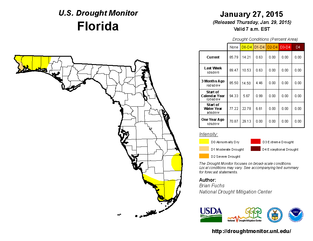
The beginning of the year started off with portions of the Florida Panhandle recovering from above average rainfall, while the rest of the state was below normal. As January progressed, widespread rain moved through the northern part of the state from the 4th – 5th, with the majority of the rainfall north of the Gainesville area. With the exception of some very localized light rain, the state remained dry until 12th, when a low-pressure system moved through, dropping over an inch of rainfall in central Florida. Drought conditions remained consistent in the Northwest Panhandle with abnormally dry (D0) conditions in Escambia, Santa Rosa, Okaloosa and Walton. However, the lack of rain in South Florida over the last 3 months lead to the introduction of D0 in Dade and Monroe counties by the middle of January. Two more rain events impacted the state- one of the 16th, which brought rain only to the Panhandle, and heavy rain was reported with the second event as it pushed through North Florida and parts of the Peninsula on the 23rd and 24th. However, the region surrounding Lake Okeechobee remained rain-free through the end of the month, promoting the expansion of D0 into Collier and Palm Beach counties.
Appendix 1: Additional January Departures from Normal Data for Florida Locations
Appendix 2: Select daily maximum and minimum temperature records (o F) tied or broken during January (Compiled from NOAA, NWS)
Prepared by Melissa Griffin and David F. Zierden.
Florida Climate Center
The Florida State University
Tallahassee, FL
Average temperatures were below normal across the state in November. The departures for average temperatures in November 2014 varied across the entire state, though most of the reporting stations saw average temperatures near normal. The departures ranged from -2.3˚F in Miami to -6.0˚F at Pensacola. (Table 1 and Appendix 1). Most stations in the Panhandle, Big Bend and North Florida recorded at least one day with a minimum temperature below freezing (32˚F) during the month. Only one station in the state, Oasis Ranger Station, reported a maximum temperature over 90˚F. November 2014 was the 2nd coldest on record in Gainesville, and the 3rd coldest on record in Jacksonville, Pensacola and Tallahassee. Multiple temperature records were tied or broken across the state in November (Appendix 2).
Table 1: November average temperatures and departures from normal (˚F) for selected cities.
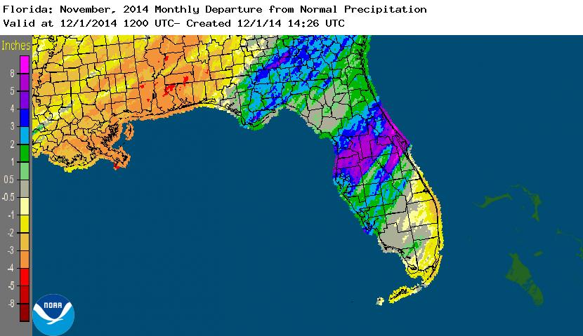
Rainfall totals varied across the state in November. Portions of the Florida Peninsula and Big Bend reported monthly rainfall totals well above normal, while the Panhandle and southeast Florida saw below average rainfall during November (Figure 1). Departures from normal roughly ranged from -3.53” to 3.71” (Table 2 and Appendix 1), though localized parts of Florida saw rainfall totals that were as much as 5.00” below normal to over 8.00” above normal (Figure 1). November 2014 was the 3rd wettest in Ocala, the 4th wettest in Tampa and Daytona Beach, the 5th wettest at Fort Myers and the 10th wettest in Orlando. Daytona Beach reported its 2nd wettest day in November since records started in 1923 on the 26th when 6.45” of rainfall was recorded. There were multiple 24-hour precipitation records broken for the month (Table 3).
Table 2: November precipitation totals and departures from normal (inches) for selected cities.
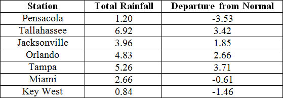
Table 3: Select daily rainfall records (inches) broken during November. (Compiled from NOAA, NWS)
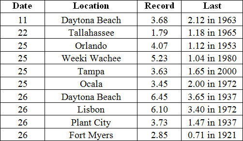
Figure 1: A graphical depiction of the monthly rainfall departure from normal (inches) for November is given in the figure below (courtesy of NOAA, NWS).
ENSO-Neutral Conditions Continue in the Pacific.
Based on current data and forecast models, the Climate Prediction Center (CPC) continue to have an El Niño Watch in place. Though Neutral ENSO conditions continue to be reported, positive sea surface temperatures (SST) anomalies have been recorded across most of the Pacific Ocean. An El Niño event is favored to develop during the Northern Hemisphere winter. CPC predicts below normal temperatures and above normal precipitation across the state through February 2015.
Hazardous Weather Events in November.
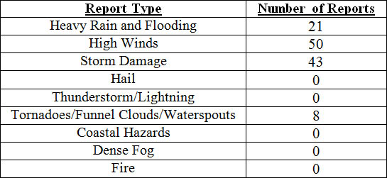
There were a total of 122 severe weather reports made in Florida during November. On the 1st, coastal portions along Duval, Brevard and St. Johns counties reported wind gusts up to 50 mph. The next severe weather day was on the 17th, when a very strong cold front pushed through the state. Storm damage, downed trees and power lines, along with wind gusts up to 60 mph were reported in various locations, such as Panama City Beach, Marianna, Lake City, Jacksonville, Tampa, Cocoa Beach, and Palm Coast. A funnel cloud was witnessed over a community near the University of North Florida in Duval County. Multiple tornadoes were also reported on the 17th. One tornado was spotted by a debris signature via dual-pol radar near Laird, FL (Bay County), and another was reported in Grand Ridge, where mobile homes were blown over. A short track EF0 tornado uprooted trees and destroyed a shed in Sanderson, FL (Baker County). The strongest tornado reported on the 17th was an EF2 that touched down south of Blountstown, FL (Calhoun County). The tornado tracked on the ground for 22-miles and was 400 yards long at its widest point. The Calhoun Correction Institute was one of the hardest hit areas with broken fence lines, flipped cars and damage to concrete buildings. Two people were injured at the facility as they waited in their cars for the storm to pass. As the tornado moved northeast, it destroyed some floating homes, sweeping debris into the Apalachicola River. The tornado finally dissipated near Sycamore, FL (Gadsden County) after being on the ground for nearly 30-minutes. On the afternoon of the 23rd, a strong line of thunderstorms pushed through the Florida Panhandle, causing storm damage in Walton, Washington, Calhoun, Liberty, and Gadsden counties. Heavy rains on the 25th and 26th were reported in numerous locations in Sumter, Volusia, Orange, Brevard, and Marion counties. Parts of Daytona Beach reported flooding over area roads from the intense rainfall.
Table 4: Breakdown of storm reports submitted in Florida during the month of November (Compiled from Southeast Regional Climate Center.)
Agricultural and other climate related impacts.
At the beginning of November, topsoil and subsoil moisture levels across the state were running more than 66% adequate and about 6% at surplus. The month started out cooler and drier across the state, allowing for the remaining peanuts to be harvested in the Panhandle and north Florida. In Holmes, Jackson and Walton counties, cotton and soybean harvesting and winter planting of rye grass and oats continued. Sugarcane harvesting progressed in Hendry, Glades and Palm Beach counties, along with a variety of vegetables in Southwest Florida. By mid-month, about 94% of the peanut harvest was completed and cotton and soybean yields were reported to be good to excellent. Cattle conditions were mainly good (74%) to excellent (6%), though there were also reports of fair (19%) conditions. Pasture conditions were fair (33%) to good (56%) as pastures across the state continued the seasonal decline, especially after an early season frost, dry conditions and mole crickets were reported in Duval County. Peanut, cotton and soybean harvests were nearly completed by the end of November. The strawberry harvest began in Hillsborough County, and the vegetable harvest in southwest Florida increased. The heavy rains at the end of the month lead to the further decline of pasture conditions across the state. A strong cold front pushed through the state, and overnight temperatures dropped to the mid 30s and lower 40s in the citrus growing areas. Typical grove activity, including irrigating, mowing, spraying and fertilizing took place in during November. In southern portions of the citrus growing region, old non-productive groves were being pushed and replaced with new plantings.
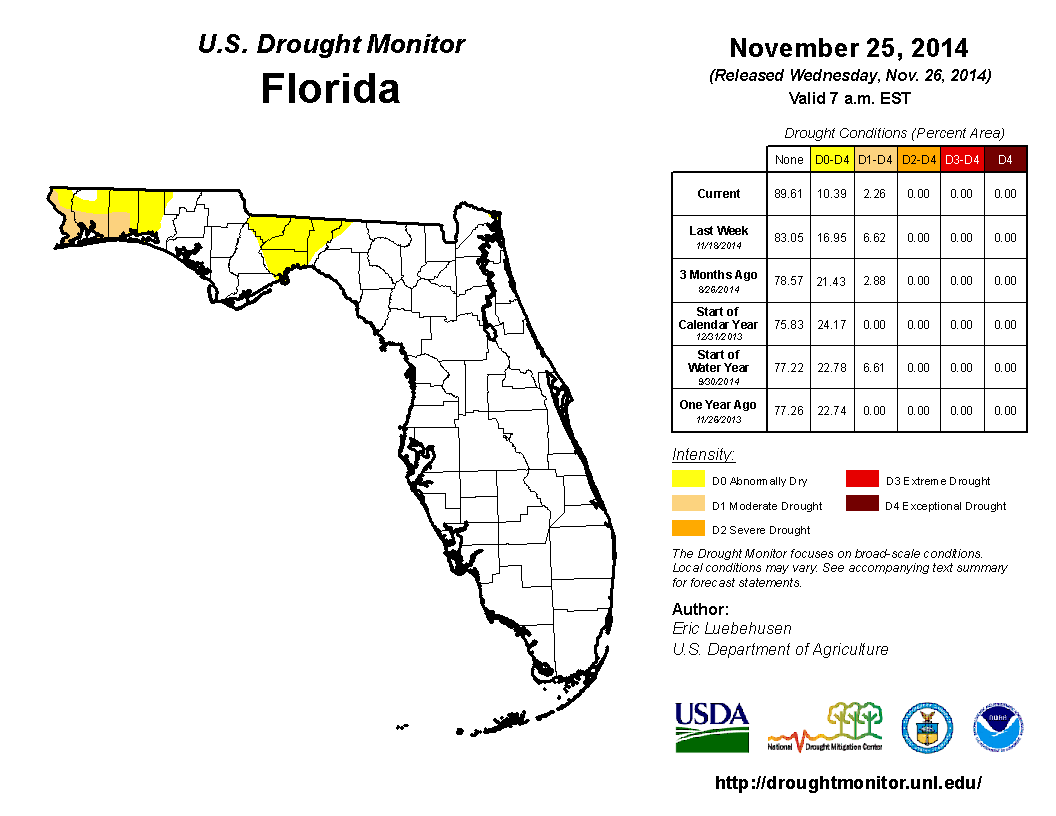
At the end of October, moderate drought (D1) conditions had been removed from eastern Big Bend counties (Madison and Taylor counties) but introduced in Franklin, Jackson and Liberty counties and much needed rainfall caused the removal of the dry conditions from the west coast and central Florida. November started off very dry for the state, with the first observed rainfall (less than 0.50”) coming on the 6th of the month in Miami-Dade County. Because of the continued lack of rainfall in the Panhandle, D1 conditions were added to coastal portions of Escambia, Santa Rosa and Okaloosa counties. Widespread rain along central and south Florida at during the middle of the month, helped keep drought conditions in check. Near the end of the month, heavy rains across portions of the Panhandle and Big Bend reduced the D1 conditions to abnormally dry (D0) in Gadsden, Leon, Jefferson and Wakulla counties. As of December 1st, Lake Okeechobee was at 15.57 ft., and a few river levels are elevated from the rains during the week of Thanksgiving.
Appendix 1: Additional November Departures from Normal Data for Florida Locations
Appendix 2: Select daily maximum and minimum temperature records (o F) tied or broken during November. (Compiled from NOAA, NWS)
Building A, Suite 292
Tallahassee, FL 32306-2741
Phone: (850) 644-3417 | (850) 644-0719
climate@coaps.fsu.edu