
Prepared by Florida Climate Center
The Florida State University
Tallahassee, FL

Average temperatures in January were near normal across much of the state. Most locations were within 2 ̊F from normal average temperatures, with most locations slightly above normal (see Table 1 and Appendix 1 for select cities). Departures from normal ranged from +2.4 ̊F in Pensacola to -0.2 ̊F in Key West. No temperature records were set during the month of January.
Table 1. January average temperatures and departures from normal ( ̊F) for selected cities.
| Station | Mean Temperature | Departure from Normal |
| Pensacola | 53.8 | +2.4 |
| Tallahassee | 52.6 | +1.4 |
| Jacksonville | 54.7 | +1.6 |
| Orlando | 60.3 | +0.1 |
| Tampa | 61.7 | +0.9 |
| Miami | 68.6 | +0.4 |
| Key West | 69.1 | -0.2 |
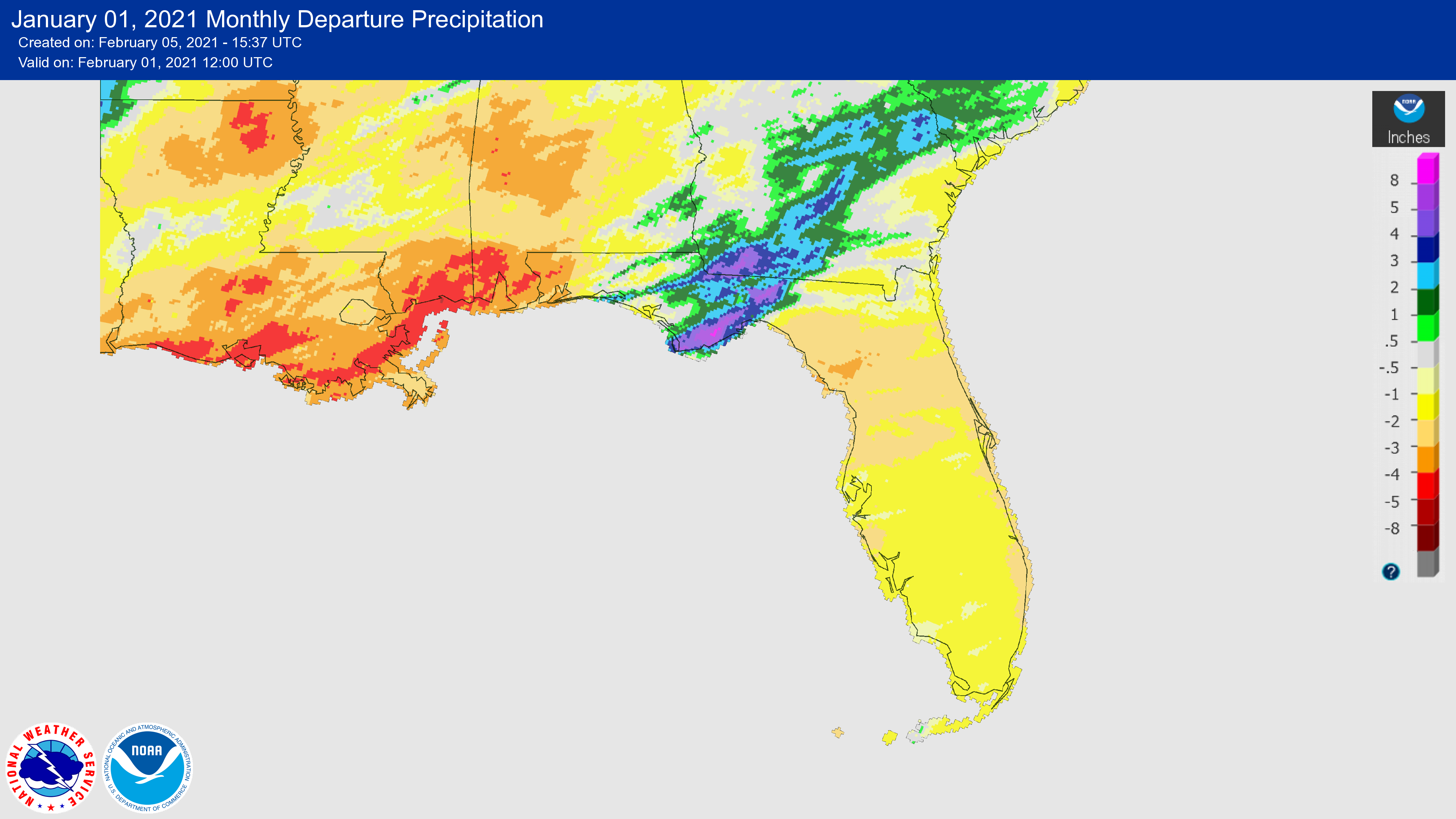
Rainfall totals in January were generally below average across the state. Monthly departures from normal ranged from -0.53 inches in Key West to -2.89 inches in Gainesville (Table 2 and Appendix 1). The central Panhandle in the Big Bend region was an exception, with rainfall departures in Tallahassee at +2.47 inches (Figure 1). There were no rainfall records set during the month of January.
Table 2. January precipitation totals and departures from normal (inches) for selected cities.
| Station | Total Rainfall | Departure from Normal |
| Pensacola | 2.78 | -1.85 |
| Tallahassee | 6.81 | +2.47 |
| Jacksonville | 1.97 | -1.33 |
| Orlando | 0.33 | -2.02 |
| Tampa | 0.82 | -1.41 |
| Miami | 0.50 | -1.12 |
| Key West | 1.51 | -0.53 |
Figure 1. A graphical depiction of the monthly rainfall departure from normal (inches) for January (courtesy of NOAA, NWS).
La Niña Conditions in the Pacific.
La Niña conditions are forecasted to continue through the Northern Hemisphere winter and early spring from January to March (~95% chance), with a possible transition to ENSO-neutral conditions during the spring (55% chance during April to June). As La Niña conditions persist, above-average temperatures and drier than average conditions are expected to continue across much of the southern tier of the U.S. over the next couple of months.
Hazardous Weather Events in January.
There were 57 individual local reports of hazardous weather events recorded in Florida during the month of January (see Table 4 for a breakdown by event type). A strong line of thunderstorms moved through central parts of the Panhandle on the 27th, with reports of tornadoes in Leon County around Tallahassee and the surrounding area. One tornado was reported at the Tallahassee airport, which knocked over one plane and damaged other planes, causing a temporary shutdown of the airport.
Table 4. Breakdown of storm reports submitted in Florida during the month of January (compiled from Iowa State University/Iowa Environmental Mesonet).
| Report Type | Number of Reports |
| Marine Thunderstorm Wind | 7 |
| Non-Thunderstorm Wind Damage | 0 |
| Non-Thunderstorm Wind Gust | 16 |
| Tornado/Waterspout/Funnel Cloud | 3/0/1 |
| Thunderstorm Wind Damage | 8 |
| Thunderstorm Wind Gust | 5 |
| Flood/Flash Flood | 2/2 |
| Heavy Rain | 13 |
Drought-Related Impacts.
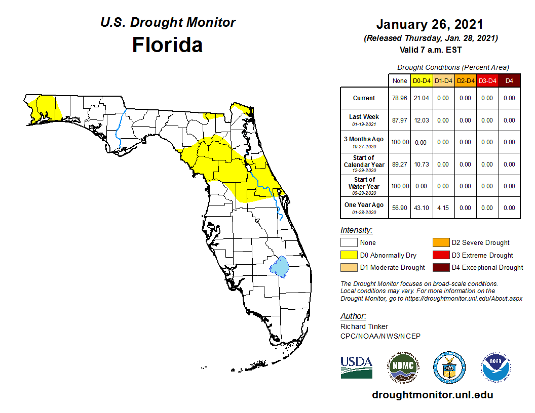
Portions of the state experienced abnormally dry conditions in January; however, no areas experienced drought conditions. During January, abnormally dry conditions (D0) emerged in the extreme northwestern Panhandle region, while abnormally dry conditions expanded across the northern part of the peninsula, according to the U.S. Drought Monitor. Roughly 12% of the state was moderately dry in January. Dry conditions are expected to continue, and the seasonal drought outlook indicates that drought development is likely through the spring in parts of Florida.
As of January 31, the Lake Okeechobee water level was at 15.47 ft. above sea level (Feet-NGVD29), which is above average for this time of the year. At the first of the month, the water level was 15.81 ft. above sea level and slowly decreased throughout the month.
Agriculture-Related Impacts.
The weekly Crop Progress and Condition reports published by the USDA’s National Agricultural Statistics Service are produced during the growing season months only, from April to November. The Crop Progress - State Stories, produced monthly December through March, for Florida indicates that pasture conditions remained mostly fair to good throughout January. Cattle conditions also remained fairly good during the month. Despite cold temperatures during the third week of January, sugarcane planting and harvesting continued with no damages reported; however, disease in strawberries was noted late in the month. Wind and large temperature swings have led to weakening of watermelon seedlings in south Florida.
Appendix 1
Additional January departures from normal data for select Florida locations (Source: NWS).
| Station | Average Temperature (˚F) | Departure from Normal (˚F) | Total Rainfall (in.) | Departure from Normal (in.) |
| Gainesville | 55.1 | +0.8 | 0.44 | -2.89 |
| Sarasota | 63.0 | +1.6 | 0.70 | -1.79 |
| Melbourne | 61.6 | +1.3 | 0.04 | -2.23 |
| Fort Myers | 64.5 | +1.5 | 0.27 | -1.68 |