
Prepared by Florida Climate Center
The Florida State University
Tallahassee, FL

Average temperatures in October 2020 were above average across the state. Departures from normal averaged 2 to 5 ̊F above normal, ranging from +2.0 ̊F in Miami to over +5 ̊F in Tallahassee and Tampa (Table 1). Tampa observed its warmest October on record while Orlando had its second warmest October on record. Average minimum temperatures were well above average for the month throughout the state, ranging from +2 ̊F in Fort Lauderdale to +8 ̊F and +9 ̊F in Tallahassee and Perry, respectively. Several locations set record high average minimum temperatures, including Perry, Tampa, Perrine, and Punta Gorda. Average maximum temperatures were also above normal across most of the state. Many daily record high maximum temperatures were set (see additional departures and records in the appendices).
Table 1. October average temperatures and departures from normal ( ̊F) for selected cities.
| Station | Mean Temperature | Departure from Normal |
| Pensacola | 73.8 | +4.2 |
| Tallahassee | 74.5 | +5.1 |
| Jacksonville | 74.6 | +3.7 |
| Orlando | 79.6 | +4.6 |
| Tampa | 81.5 | +5.4 |
| Miami | 82.2 | +2.0 |
| Key West | 82.7 | +1.4 |
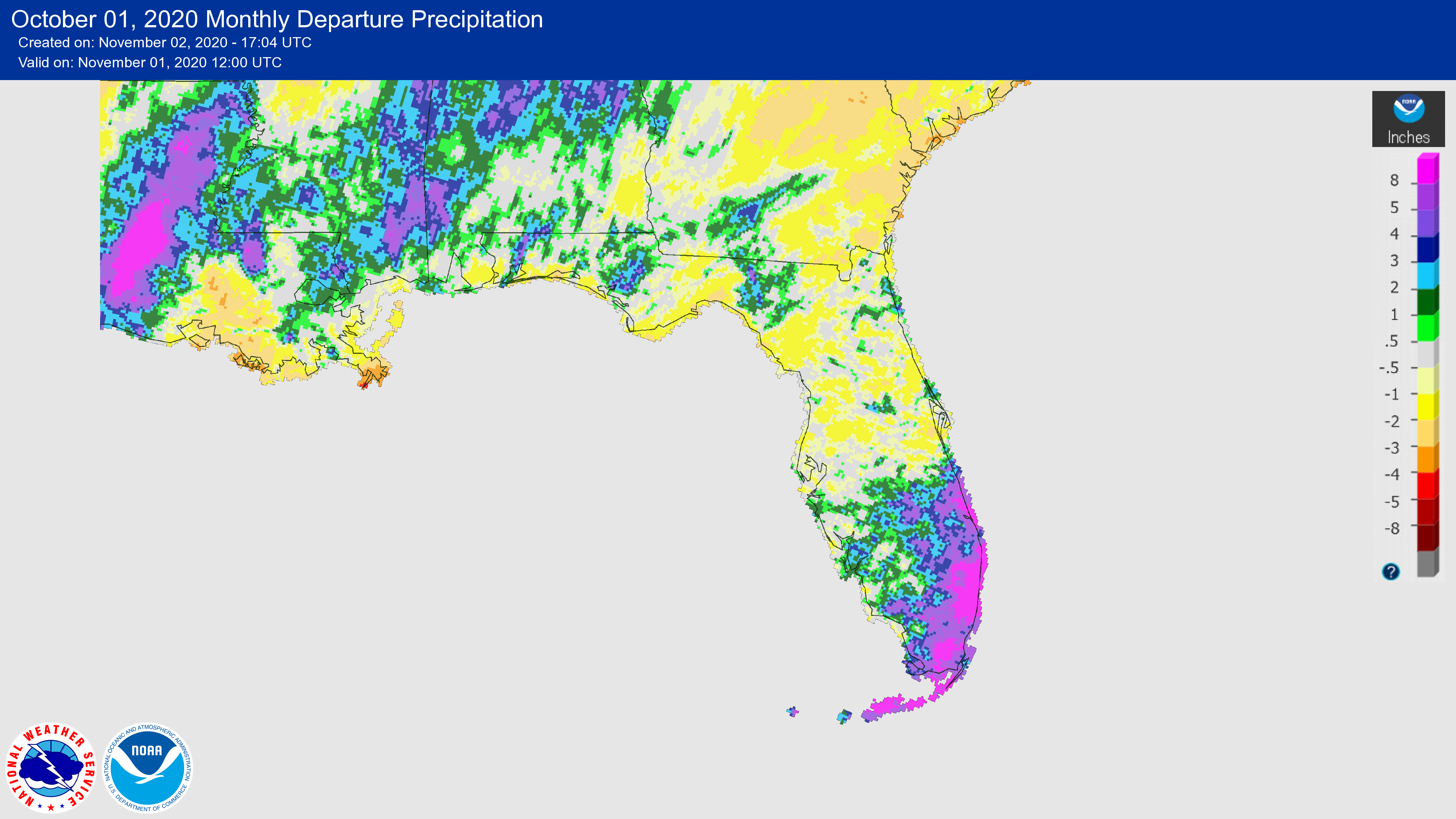
Rainfall totals in October were below normal across northern and central parts of the state and above normal in the southern peninsula (Table 2 and Figure 1). Perrine and Fort Lauderdale experienced their second wettest October on record, at +8.5 and +7.4 inches above normal for the month, respectively.
Table 2. October precipitation totals and departures from normal (inches) for selected cities.
| Station | Total Rainfall | Departure from Normal |
| Pensacola | 5.00 | -0.24 |
| Tallahassee | 2.01 | -1.22 |
| Jacksonville | 3.49 | -0.92 |
| Orlando | 2.01 | -1.22 |
| Tampa | 1.84 | -0.42 |
| Miami | 11.86 | +5.53 |
| Key West | 7.78 | +2.84 |
Figure 1. A graphical depiction of the monthly rainfall departure from normal (inches) for October 2020 (courtesy of NOAA, NWS).
La Niña Conditions Persist in the Pacific.
Strong La Niña is forecast for the rest of the fall, as the threshold for what is considered a strong La Niña has been crossed. There is a more than 90% chance of La Niña continuing through winter and a strong chance (approximately 60%) it will continue into the spring (February-April). La Niña conditions emerged in August with sea surface temperatures (SST) dipping below average across the central and eastern equatorial Pacific Ocean. La Niña is expected to affect temperatures and precipitation during the upcoming months, with above-average temperatures and dry conditions across the southern tier of the U.S.
Hazardous Weather Events in October.
There were 340 local reports of hazardous weather events recorded in Florida during the month of October (see Table 4 for a breakdown by event type). The active hurricane season in the Atlantic continued in October. Hurricane Zeta impacted the Gulf Coast late in the month of October, making landfall over southeast Louisiana on Wednesday the 28th and then moving northeast across southern Mississippi and Alabama. While there were some reports of wind gusts, Florida was spared from the worst impacts of Zeta.
Table 4. Breakdown of storm reports submitted in Florida during the month of October (compiled from Iowa State University/Iowa Environmental Mesonet).
| Report Type | Number of Reports |
| Coastal Flood | 21 |
| Flash Flood | 6 |
| Flood | 37 |
| Heavy Rain | 93 |
| Marine Thunderstorm Wind | 91 |
| Non-Thunderstorm Wind Damage | 0 |
| Non-Thunderstorm Wind Gust | 33 |
| Tornados/Waterspouts/Funnel Clouds | 0/8/1 |
| Thunderstorm Wind Damage | 0 |
| Thunderstorm Wind Gust | 19 |
| Lightning | 1 |
| High Tide | 7 |
| Rip Current | 3 | Tropical Storm | 20 |
Drought-Related Impacts.
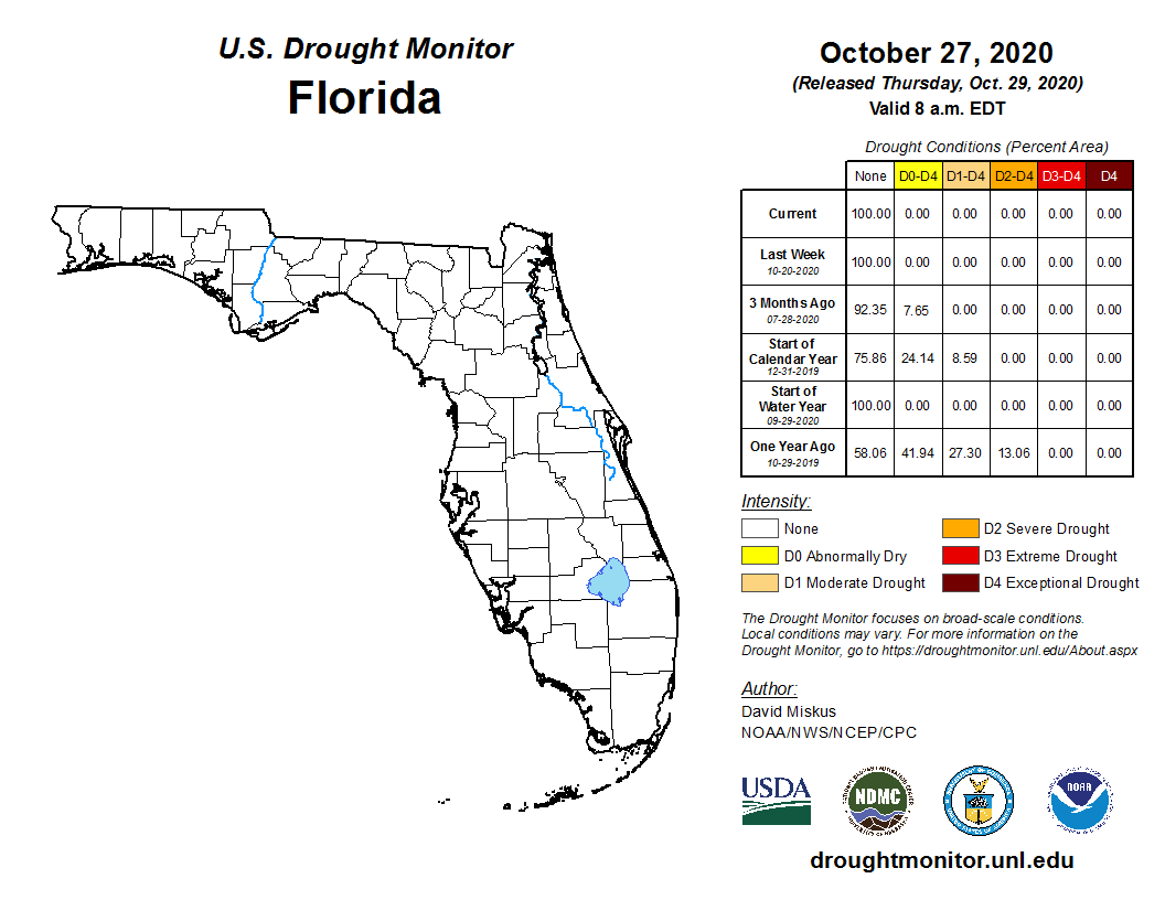
During the month of October, drought did not impact any part of the state, according to the U.S. Drought Monitor. Drought-free conditions are expected to remain in the short term but continuing La Niña conditions are expected to lead to the onset of a dry winter pattern.
As of October 31, the Lake Okeechobee water level was at 16.26 ft. above sea level (Feet-NGVD29), which is above average for this time of the year. At the beginning of October, the water level was at 15.56 ft. above sea level.
Agriculture-Related Impacts.
By mid-October, topsoil moisture levels were adequate in 64% of the state, short in 14%, very short in 1%, and 21% of the state was in surplus. By the end of October, topsoil moisture levels were adequate in 67% of the state, short in 5%, very short in 1%, and 27% of the state had a surplus. For more information, consult the weekly Crop Progress and Condition reports published by the USDA’s National Agricultural Statistics Service.
Appendix 1
Additional October departures from normal data for Florida locations (Source: NWS).
| Station | Average Temperature (˚F) | Departure from Normal (˚F) | Total Rainfall (in.) | Departure from Normal (in.) |
| Gainesville | 75.2 | +4.4 | 1.74 | -1.14 |
| Sarasota | 81.2 | +4.9 | 3.76 | +0.64 |
| Melbourne | 79.4 | +3.4 | 4.89 | -0.17 |
| Fort Myers | 81.4 | +4.4 | 4.05 | +1.17 |
Appendix 2
Select daily maximum temperature records tied or broken during October (compiled from NOAA).
| Location | Date | Record (˚F) | Broken/Tied | Last |
| Key West | 1 | 92 | Broken | 91 in 2018 |
| Key West | 4 | 91 | Broken | 90 in 2018 |
| Key West | 5 | 92 | Broken | 91 in 2018 |
| Tampa | 6 | 94 | Broken | 93 in 2017 |
| Punta Gorda | 7 | 95 | Broken | 93 in 2018 |
| Orlando | 7 | 93 | Tied | 93 in 2009 |
| Tampa | 8 | 95 | Broken | 92 in 1990 |
| Key West | 9 | 92 | Tied | 93 in 2009 |
| Jacksonville | 12 | 90 | Broken | 89 in 2018 |
| Miami | 12 | 92 | Broken | 91 in 2011 |
| Fort Lauderdale | 13 | 93 | Broken | 92 in 2008 |
| Pensacola | 13 | 90 | Tied | 90 in 2017 |
| Fort Lauderdale | 14 | 93 | Broken | 92 in 2003 |
| Tampa | 15 | 93 | Broken | 92 in 2018 |
| Tampa | 19 | 90 | Broken | 89 in 2018 |
| Tarpon Springs | 26 | 90 | Tied | 90 in 2010 |
| Tampa | 26 | 92 | Broken | 90 in 1939 |
| Kissimmee | 27 | 91 | Broken | 90 in 2019 |
| Tampa | 27 | 92 | Broken | 89 in 2010 |
| Key West | 27 | 90 | Broken | 89 in 2019 |
| Key West | 28 | 91 | Broken | 90 in 2019 |
| Jacksonville Beach | 29 | 90 | Broken | 88 in 2019 |
| Vero Beach | 29 | 90 | Broken | 88 in 2019 |
| Jacksonville | 29 | 90 | Broken | 87 in 2019 |
| Daytona Beach | 30 | 90 | Broken | 88 in 2014 |