Prepared by Florida Climate Center
The Florida State University
Tallahassee, FL
Summary:
- Overall, December monthly temperatures averaged out to near normal for the month.
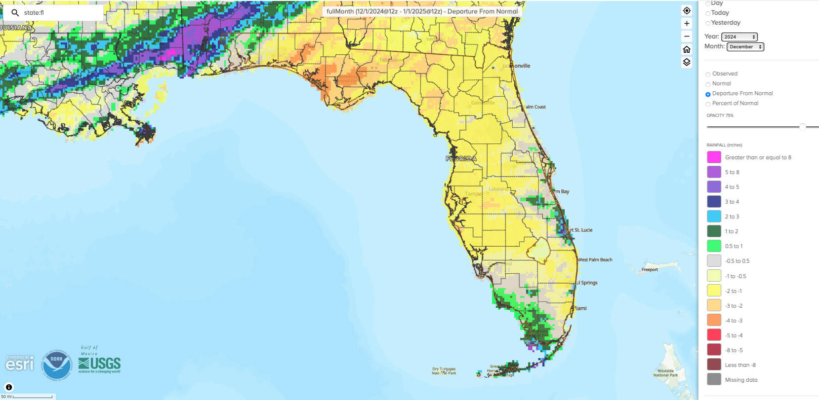
- Monthly precipitation totals were below normal in December in Florida, except for the east-central and southwestern coasts and Keys.
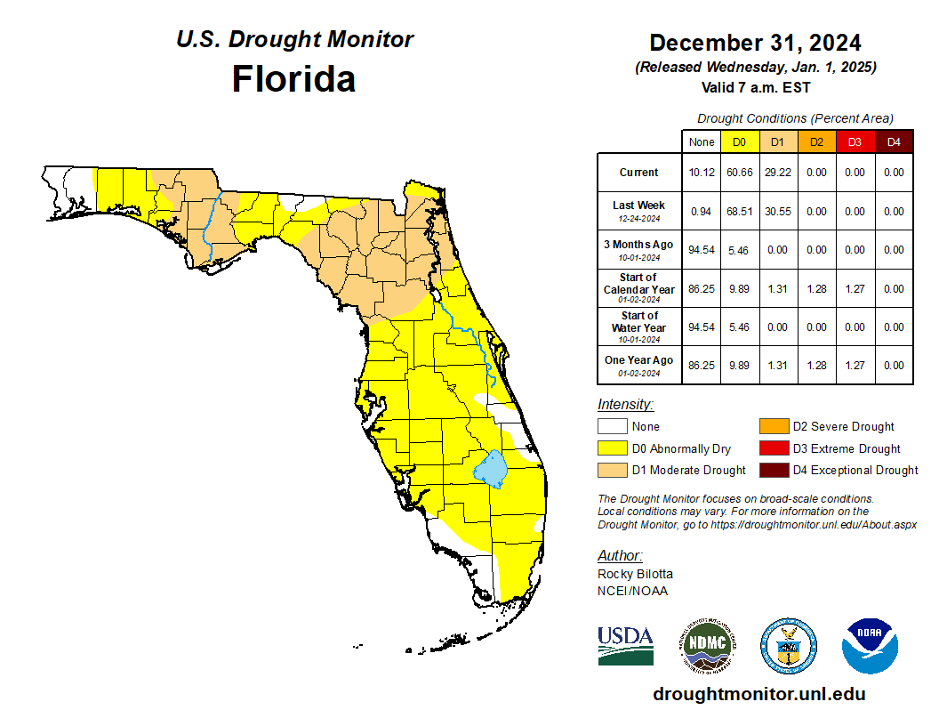
- By the end of the month, approximately 29% of the state was in moderate drought (D1) and 61% was abnormally dry (D0), according to the U.S. Drought Monitor.
- La Niña conditions emerged in the tropical equatorial Pacific Ocean during December 2024 and are expected to persist through February-April 2025 (59% chance) before transitioning to ENSO-neutral likely during March-May 2025 (60% chance).
While temperatures fluctuated throughout the month, overall average monthly temperatures in December ended up near normal in Florida. Average monthly temperature departures from normal ranged from -1.3 ̊F in Key West to +1.2 ̊F in Tallahassee for the month (see Table 1 and Appendix 1 for select cities). A cold front impacted the northern half of the state during the first week of the month and led to freezing temperatures across the Panhandle. Minimum temperatures fell to a low of 25 ̊ F in Tallahassee and 26 ̊ F in Gainesville on the 4th. Despite the cold start to the month, temperatures during the second half of December were generally above normal to close out another warm year in Florida. Average temperature departures from normal during the last week of the month ranged from +4-8 ̊ F above normal, with some isolated stations reporting even warmer conditions. Statewide, December 2024 ranked 48th-warmest over the past 130 years with a statewide monthly average temperature of 60.9 ̊F, which was 2.1 ̊F above the long-term mean.
Table 1. December average temperatures and departures from normal ( ̊F) for selected cities.
| Station | Mean Temperature | Departure from Normal |
| Pensacola | 56.0 | +0.5 |
| Tallahassee | 55.6 | +1.2 |
| Jacksonville | 57.0 | +0.3 |
| Orlando | 63.9 | +0.6 |
| Tampa | 64.8 | -0.1 |
| Miami | 71.7 | +0.5 |
| Key West | 71.7 | -1.3 |
Monthly precipitation totals were below normal in December, except for the east-central and southwestern coasts and Keys. The monthly precipitation departures from normal ranged from -3.05 inches in Tallahassee to +1.15 inches in Key West (see Table 2 and Appendix 1 for select locations). Sarasota/Bradenton had its 4th-driest December on record (based on 109 years), and Tallahassee had its 8th-driest December on record (based on 114 years). Statewide, December 2024 ranked as the 39th-driest December on record. While December was dry, many stations closed out the calendar year with a surplus of rainfall. Both Tampa and Fort Myers recorded their wettest year on record in 2024 (Jan. 1 - Dec. 31) with +30.51 inches and +23.04 inches of surplus rainfall compared to normal, respectively.
Table 2. December precipitation totals and departures from normal (inches) for selected cities.
| Station | Total Rainfall | Departure from Normal |
| Pensacola | 5.12 | -0.28 |
| Tallahassee | 1.19 | -3.05 |
| Jacksonville | 1.08 | -1.70 |
| Orlando | 1.83 | -0.65 |
| Tampa | 0.78 | -1.78 |
| Miami | 1.18 | -1.26 |
| Key West | 3.31 | +1.15 |
Figure 1. A graphical depiction of the monthly rainfall departure from normal (inches) for December (courtesy of NOAA, NWS).

La Niña Advisory.
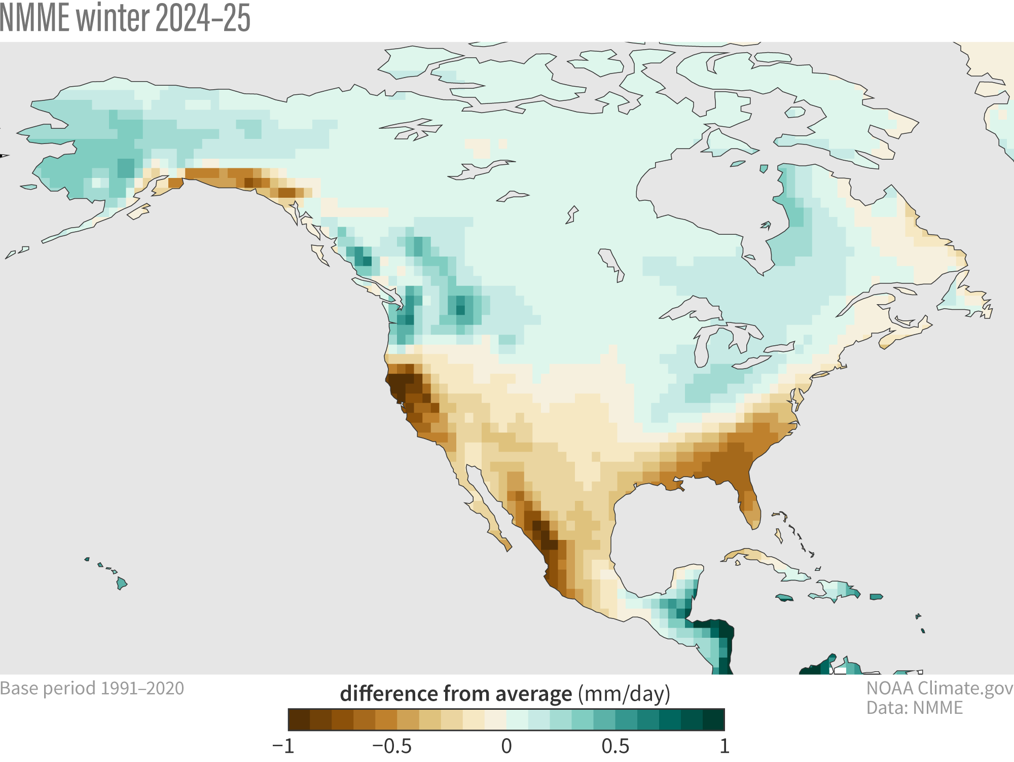
During December 2024, La Niña conditions emerged in the tropical equatorial Pacific Ocean as sea surface temperatures fell below average in the central and eastern equatorial Pacific Ocean. The latest weekly Niño indices were -0.7 ̊C in the Niño-3.4 and -0.6 ̊C in the Niño-4 regions. Models continue to indicate a weak La Niña during this winter season, persisting through February-April 2025 (59% chance) before transitioning to ENSO-neutral likely during March-May 2025 (60% chance). While weak La Niña events are less likely to result in conventional winter/spring impacts, it can still influence the CPC seasonal forecast guidance. Currently, the North American Multi-Model Ensemble (NMME) forecasts a typical La Niña signature with drier than normal conditions this winter (December – February) across the southern tier of the U.S. (Figure 2)

Hazardous Weather Events in December.
According to the Local Storm Reports issued by the local National Weather Service offices serving Florida, there were 71 individual local reports of hazardous weather events recorded across the state during the month of December (see Table 3 for a breakdown by event type). Severe thunderstorms affected parts of the state in December, with heavy rainfall, hail, and damaging winds.
Table 3. Breakdown of storm reports submitted in Florida during the month of December (compiled from Iowa State University/Iowa Environmental Mesonet).
| Report Type | Number of Reports |
| Heavy Rain | 2 |
| Flood | 5 |
| Flash Flood | 0 |
| Hail | 3 |
| Marine Thunderstorm Wind | 9 |
| Non-Thunderstorm Wind Gust | 12 |
| Non-Thunderstorm Wind Damage | 0 |
| Tornado/Waterspout/Funnel Cloud | 0/0/0 |
| Thunderstorm Wind Damage | 10 |
| Thunderstorm Wind Gust | 30 |
| Rip Currents | 0 |
Daily Record Events in December.
Table 4. Summary of daily records broken or set in Florida in December (source: NCEI Daily Weather Records).
| Category | Number of Records |
| Highest daily max. temp. | 11 |
| Highest daily min. temp. | 12 |
| Lowest daily max. temp. | 1 |
| Lowest daily min. temp. | 4 |
| Highest daily precipitation | 15 |
| Total | 43 |
Drought-Related Impacts.
In mid-December, about 29% of the state was in moderate drought (D1) and roughly 70% of the state was abnormally dry (D0), according to the U.S. Drought Monitor. Conditions stayed about the same for the remainder of the month. By the end of the month, moderate drought (D1) continued to affect about 29% of the state and 61% of the state remained abnormally dry (D0) (Figure 3 below).
As of January 1, the Lake Okeechobee water level was 15.12 ft. above sea level (Feet-NGVD29), which is above average for this time of year. At the first of the month, the water level was around 15.70 ft. above sea level.
Figure 3. A graphical depiction of the latest drought conditions in Florida according to the U.S. Drought Monitor (courtesy of the National Drought Mitigation Center, University of Nebraska-Lincoln).

Agriculture-Related Impacts.
Total monthly rainfall fell short in December, with nearly 90% of the state in moderate drought (D1) or experiencing abnormally dry conditions (D0) by the end of the month. Pasture conditions were mostly fair to good during December, despite the cold and dry weather at the beginning of the month that led to freezes. Cattle remained in mostly good to fair condition. Sugarcane planting and harvesting progressed well and grove operations continued. Crops planted and harvested included strawberries, squash, peppers, tomato, snap peas, and others. For more information, consult the Crop Progress State Stories, which is published by the USDA’s National Agricultural Statistics Service December through March.
Appendix 1
Additional December departures from normal data for select Florida locations (Source: NWS).
| Station | Average Temperature (˚F) | Departure from Normal (˚F) | Total Rainfall (in.) | Departure from Normal (in.) |
| Gainesville | 57.0 | -0.3 | 1.38 | -1.50 |
| Sarasota | 65.8 | +0.6 | 0.18 | -2.15 |
| Melbourne | 64.9 | +0.2 | 2.98 | +0.62 |
| Fort Myers | 67.5 | +0.2 | 1.41 | -0.49 |
| West Palm Beach | 69.6 | +0.6 | 1.16 | -2.32 |


