
Prepared by Florida Climate Center
The Florida State University
Tallahassee, FL

Summary:
- Average monthly temperatures in September were mostly above normal, with the exception of the western Panhandle.
- Monthly precipitation totals were mostly above normal in September, but below normal in southern Florida.
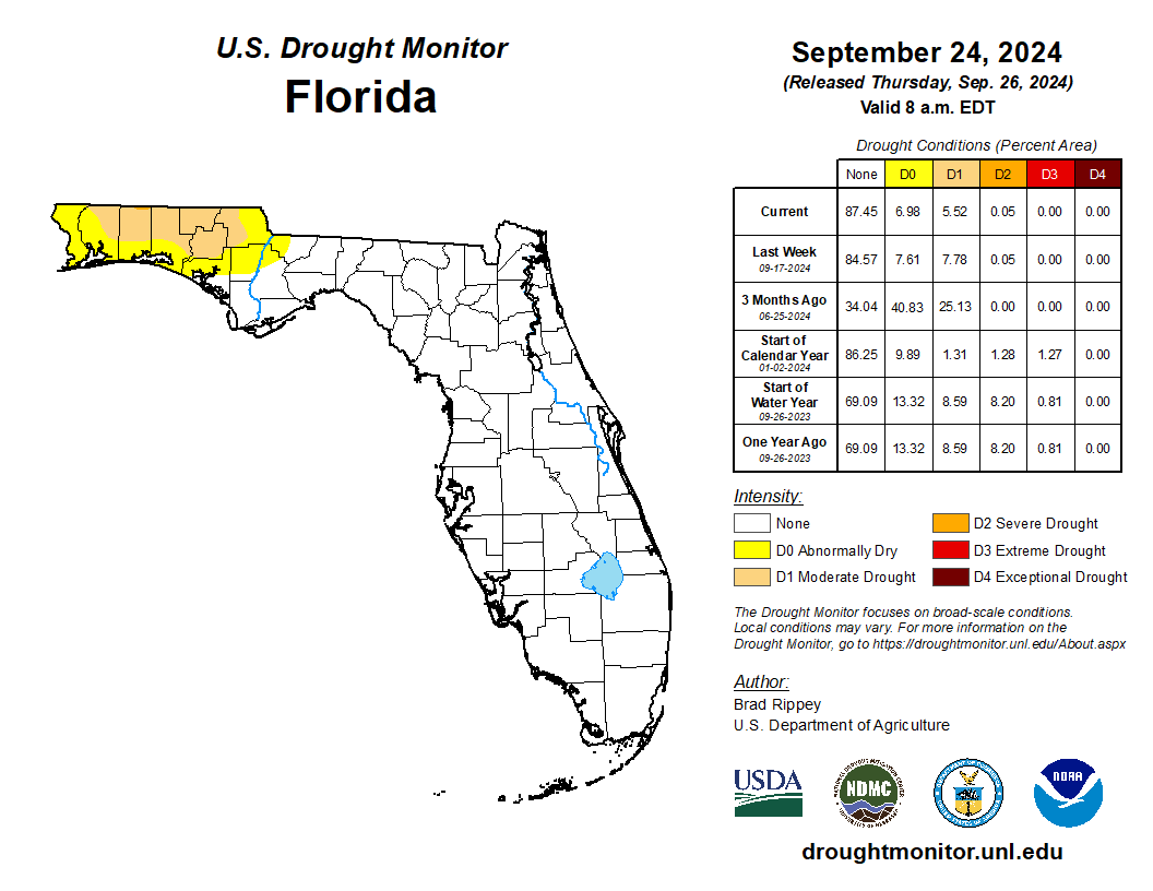
- Drought improvement occurred in the western Panhandle during September; 6% of the state was in moderate drought (D1) and 7% was abnormally dry (D0) as of September 26.
- A transition to La Niña conditions is favored during September-November (71% chance); La Niña is expected to persist through January-March 2025.
- Hurricane Helene made landfall in Florida’s Big Bend in Taylor County just southwest of Perry on the night of September 26 as a category 4 hurricane with peak winds of 140 mph. It became the third hurricane in 13 months to strike this part of the state.
Average monthly temperatures in September were mostly above normal, except in the far western Panhandle. Average monthly temperature departures from normal ranged from -1.1 ̊F in Pensacola to +2.2 ̊F in Orlando for the month (see Table 1 and Appendix 1 for select cities). South Florida was especially warm in September. September 2024 ranked as the warmest September on record for Key West (150 years), West Palm Beach (131 years), Punta Gorda (108 years), Vero Beach (81 years), and Plant City (115 years). It was the 2nd-warmest September on record for Ft. Lauderdale (103 years), Ft. Myers (122 years), and Tampa (135 years).
Table 1. September average temperatures and departures from normal ( ̊F) for selected cities.
| Station | Mean Temperature | Departure from Normal |
| Pensacola | 78.9 | -1.1 |
| Tallahassee | 80.7 | +1.6 |
| Jacksonville | 79.7 | +0.9 |
| Orlando | 83.2 | +2.2 |
| Tampa | 84.0 | +1.3 |
| Miami | 84.7 | +1.7 |
| Key West | 86.2 | +2.1 |
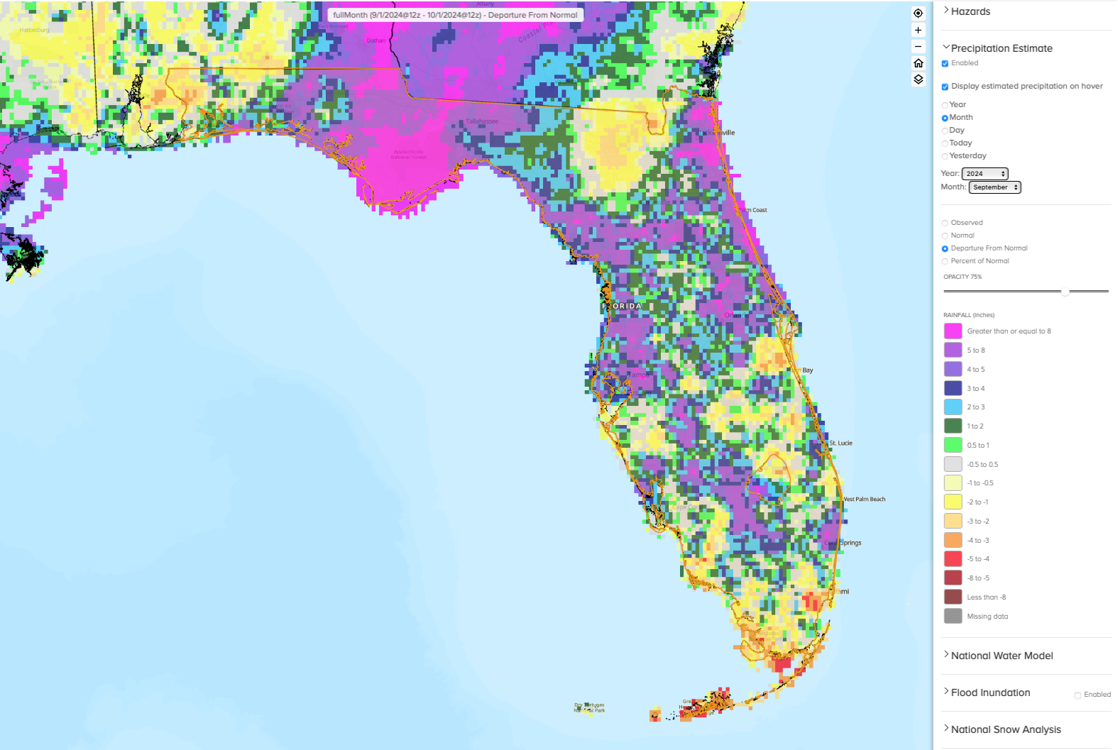
Monthly precipitation totals were mostly above normal in September, but below normal in southern Florida. The monthly precipitation departures from normal ranged from -3.90 inches in Key West to +21.61 inches in Apalachicola (see Table 2 and Appendix 1 for select locations). A stalled frontal boundary brought ample rainfall to the Florida Peninsula and Northeast Florida during the early part of the month. By the 5th, Tampa had already observed 9.23 inches of rain since the first of the month, which was the wettest on record for the September 1-5 period. The Jacksonville area observed over 10 inches of rain by September 15. Several CoCoRaHS stations across the Jacksonville and northeast coastal areas reported over 15 inches of rain during the first half of September, with a peak of 21.89 inches recorded by an observer in St. Johns County (FL-SJ-29). From September 1-15, the Jacksonville Intl AP station recorded 11.42 inches of rain, ranking 4th-wettest on record (85 years), and Daytona Beach recorded 10.97 inches of rain, which ranked as 3rd-wettest on record (88 years) for this period. For the entire month, Apalachicola recorded a total of 26.99 inches of rain, which was +21.61 inches above normal and ranked as the wettest September on record (89 years). Year-to-date rainfall in Apalachicola is now +29.18 inches above normal. Rainfall in the western Panhandle led to drought improvement during the month (see Figure 2). Below normal rainfall was observed in Miami, Naples, and the Keys.
Table 2. September precipitation totals and departures from normal (inches) for selected cities.
| Station | Total Rainfall | Departure from Normal |
| Pensacola | 8.69 | +2.08 |
| Tallahassee | 11.21 | +6.30 |
| Jacksonville | 13.53 | +5.97 |
| Orlando | 5.38 | -0.99 |
| Tampa | 13.35 | +7.26 |
| Miami | 9.11 | -1.11 |
| Key West | 3.34 | -3.90 |
Figure 1. A graphical depiction of the monthly rainfall departure from normal (inches) for September (courtesy of NOAA, NWS).
La Niña Watch.
ENSO-neutral conditions have continued in the tropical equatorial Pacific Ocean over the past month. La Niña conditions are expected to emerge during September-November 2024 (now at 71% chance) and persist through the Northern Hemisphere winter (January-March 2025). Models predict a weak and short duration La Niña event. The Climate Prediction Center’s seasonal outlook reflects equal chances of below, above, or near normal precipitation in Florida and the Southeast U.S. from October-December 2024.
Hazardous Weather Events in September.
According to the Local Storm Reports issued by the local National Weather Service offices serving Florida, there were 716 individual local reports of hazardous weather events recorded across the state during the month of September (see Table 4 for a breakdown by event type). Heavy rainfall associated with a stalled frontal boundary affected Florida in early September, generally from September 4-6. Heavy rainfall led to street flooding in Tampa and surrounding areas, as well as in Duval, St. Johns, and surrounding counties of Northeast Florida. A station in the Durbin area of St. Johns County reported 4 inches of rain in just over one hour on the 4th. On the 13-14, heavy rains and flooding impacted the Panhandle. Two-day rainfall totals in Franklin County included 12.62 inches recorded in Lanark Village, 12.23 inches on St. George Island, and 11.87 inches at the Apalachicola Airport. At the end of the month, Hurricane Helene impacted much of the state. The storm’s expansive wind field led to tropical storm force winds or greater as far as Florida’s east coast and brought major coastal flooding along the west coast of Florida and Big Bend regions. Read more about the storm below.
Table 3. Breakdown of storm reports submitted in Florida during the month of September (compiled from Iowa State University/Iowa Environmental Mesonet).
| Report Type | Number of Reports |
| Heavy Rain | 154 |
| Flood | 53 |
| Flash Flood | 54 |
| Coastal Flood | 9 |
| Hail | 0 |
| Marine Thunderstorm Wind | 9 |
| Non-Thunderstorm Wind Gust | 46 |
| Non-Thunderstorm Wind Damage | 5 |
| Tornado/Waterspout/Funnel Cloud | 0/20/10 |
| Thunderstorm Wind Damage | 6 |
| Thunderstorm Wind Gust | 62 |
| Lightning | 4 |
| Tropical Cylone | 274 |
| Storm Surge | 9 |
Weather/Climate Highlights of the Month: Hurricane Helene
Hurricane Helene made landfall as a category 4 storm southwest of Perry, FL in Taylor County on the night of September 26 with peak winds of 140 mph. The storm’s expansive wind field led to tropical storm force winds, or even higher at times, as far as Florida’s east coast, hundreds of miles away from the storm’s center.
Due to its fast forward motion (at 23 mph) and distance from the coast, Helene did not produce heavy rainfall in central or south Florida. However, the storm produced record storm surge and caused major coastal flooding along Florida’s west coast with strong onshore winds, even as the storm’s center was about 170 miles west-southwest of Tampa.
The highest rainfall totals in Florida were found along the west side of the storm’s center around landfall in North Florida, with peak rainfall just west of Tallahassee. Rainfall totals were 6-12 inches in the Panhandle and much higher further north into Georgia and the Appalachians, where the storm’s moisture was amplified by uplift from the mountainous terrain and precursor rainfall from a stalled cold front.
Helene’s development and intensification in the Gulf of Mexico was aided by above normal water temperatures in the Gulf of Mexico, low atmospheric wind shear, and its track over the Gulf loop current which is an area of very warm waters. These factors led to rapid intensification, as the storm intensified from a Category 1 to a Category 4 hurricane on Thursday prior to landfall that night.
Helene became the 3rd hurricane in 13 months to make landfall in the Big Bend region, following Hurricanes Idalia in August 2023 (category 3) and Debby in August 2024 (category 1). It was the 7th hurricane to make landfall in the Panhandle or Big Bend in the past 9 years since 2016.
Drought-Related Impacts.
By mid-September, about 8% of the state was experiencing moderate drought (D1) and 8% was abnormally dry (D0), according to the U.S. Drought Monitor. By the end of the month, drought improved slightly with 5.5% of the state in moderate drought (D1) and 7% abnormally dry (D0) (Figure 2 below).
As of September 30, the Lake Okeechobee water level was 15.33 ft. above sea level (Feet-NGVD29), which is above average for this time of year. At the first of the month, the water level was 14.28 ft. above sea level.
Figure 2. A graphical depiction of the latest drought conditions in Florida according to the U.S. Drought Monitor (courtesy of the National Drought Mitigation Center, University of Nebraska-Lincoln).
Agriculture-Related Impacts.
Following a wet summer, September brought more rain to much of Florida and wet conditions have led to crop damages. In mid-September, topsoil moisture conditions were adequate in 66% of the state, short in 7%, and very short in 2% of the state, while 25% of the state had surplus topsoil moisture conditions. By the end of September, topsoil moisture conditions were adequate in 48% of the state, short in 8%, and very short in 3% of the state; surplus topsoil moisture conditions increased to 41% of the state. For more information, consult the Crop Progress and Conditions report, which is published by the USDA’s National Agricultural Statistics Service.
Appendix 1
Additional September departures from normal data for select Florida locations (Source: NWS).
| Station | Average Temperature (˚F) | Departure from Normal (˚F) | Total Rainfall (in.) | Departure from Normal (in.) |
| Apalachicola | 80.4 | +1.2 | 26.99 | +21.61 |
| Gainesville | 79.4 | +0.6 | 7.61 | +2.56 |
| Sarasota | 83.1 | +0.9 | 7.50 | +1.50 |
| Naples | 84.3 | +1.9 | 6.24 | -2.36 |
| Fort Myers | 84.4 | +2.2 | 10.84 | +1.84 |
| West Palm Beach | 84.4 | +2.5 | 11.20 | +3.24 |