Prepared by Preston Leftwich, David F. Zierden, and Melissa Griffin
Florida Climate Center
The Florida State University
Tallahassee, FL

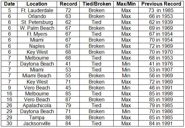
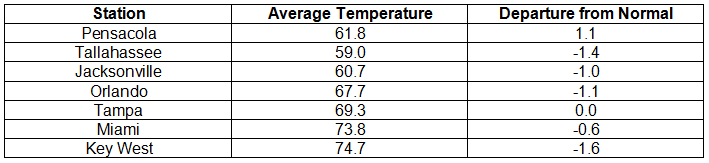
Average temperatures near normal for November. Overall, average temperatures for November were near normal (Table 1). During the first half of the month record low maximum temperatures were tied or broken in southern areas. A maximum temperature of 62° F at St. Perersburg on the 6th tied the lowest daily maximum, a record in existence since 1939. Several minimum temperature records were tied or broken, too. The minimum temperature at Miami on the 7th (53° F) tied a record in existence since 1907. Later in the month, several daily maximum temperature records were set (Appendix).
Table 1: November average temperatures and departures from normal (° F) for selected cities.
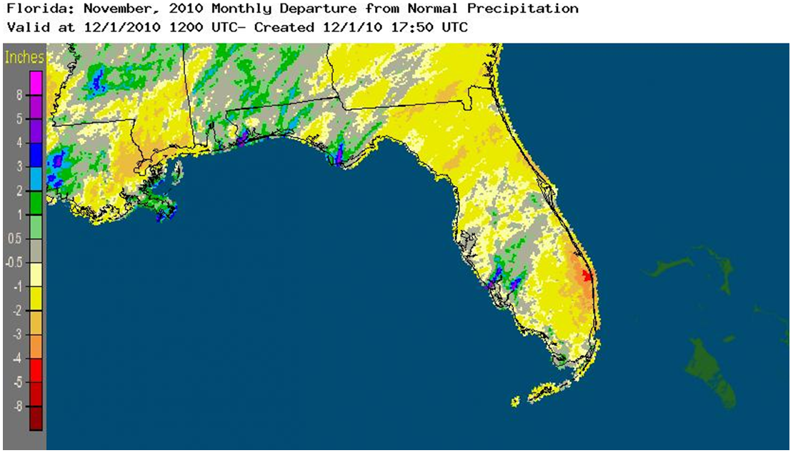
November rainfall totals near normal in most areas. Rainfall totals for November were near normal in most areas of the state (Table 2). In contrast, the monthly total of 7.33 inches recorded at Pensacola was nearly three inches above normal. A daily amount of 3.34 inches at Pensacola on the 3rd was a primary factor in the monthly total being above normal. Two daily rainfall records were set durng the month. On the 16th, 2.22 inches of rain broke the record of 1.05 in that occurred in 1957. An amount of 0.78 inch at Key West on the 26th broke the record of 0.61 inch that occurred in 1987. Monthly departures from normal November rainfall are depicted in Figure 1. While Panhandle areas were near or slightly above normal, an area along the south-central coast was more than four inches below normal.
Table 2: November precipitation totals and departures from normal (inches) for selected cities.
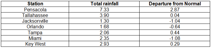
Figure 1: A graphical depiction of the monthly rainfall departure from normal (inches) for November is given in the figure below (courtesy of NOAA, NWS).
La Nina continues during November. Sea surface temperatures in the equatorial Pacific Ocean continued below normal during November, denoting a continued cold phase of ENSO, or La Nina. As a very active Atlantic hurricane season came to an end, no tropical cyclones affected the state during November.
Hazardous weather. No tornadoes were observed during the month. Only isolated severe local storms occurred. On the 2nd, golf-ball-sized hail fell near Pensacola. On the 15th, trees and power lines were downed by thunderstorm winds near Monticello. All areas of the state except the extreme southeast and Keys continued to experience drought conditions during November. Two areas, along the upper east coast and near the central east coast, reached extreme drought conditions by the end of the month. Although drought conditions eased somewhat in the Panhandle during November, areas near the borders of Alabama and Georgia still have moderate to severe drought conditions.
Agricultural and other impacts. Planting of cool season forage was delayed due to low soil moisture. Cattle producers continued to use hay as supplemental feed due to slowness of pasture growth. Frost and freezing temperatures in northern areas ended late vegetable production. Cooler weather aided strawberry development in west-central areas. By the end of the month citrus areas in Broward and Indian River Counties had reached extreme drought conditions.
Appendix: Temperature Records (° F) Tied or Broken during November (compiled from NWS).