Prepared by Melissa Griffin and David F. Zierden.
Florida Climate Center
The Florida State University
Tallahassee, FL

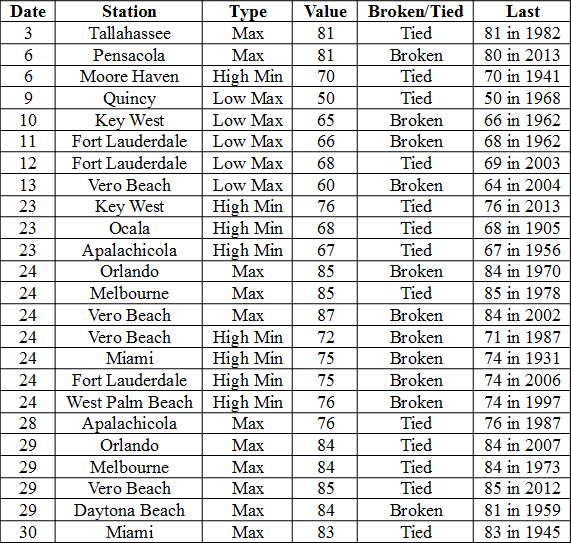
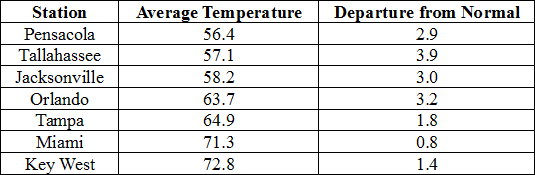
Average temperatures were above normal across the state in December. The departures for average temperatures in December 2014 for the Peninsula were above normal, though most of the reporting stations in the northern part of the state saw average temperatures well above normal. The departures ranged from 0.8˚F in Miami to 3.9˚F at Tallahassee. (Table 1 and Appendix 1). Despite the warm month, some stations in the Panhandle, Big Bend and North Florida recorded at least one day with a minimum temperature below freezing (32˚F) during the month; and no stations reported a maximum temperature over 90˚F. Multiple temperature records were tied or broken across the state in December (Appendix 2).
Table 1: December average temperatures and departures from normal (˚F) for selected cities.
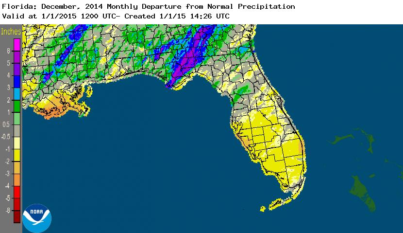
Rainfall totals varied across the state in December. A very localized portion of the Big Bend reported monthly rainfall totals well above normal, while the rest of Florida saw average rainfall during December near to below normal (Figure 1). Departures from normal roughly ranged from -2.16” to 4.88” (Table 2 and Appendix 1), though localized parts of Florida saw rainfall totals that were as much as 4.00” below normal to over 8.00” above normal (Figure 1). Tallahassee reported its wettest day in December since records started in 1892 on the 23rd when 7.44” of rainfall was recorded. 2014 was the 9th wettest year in Pensacola (83.17”) and the 10th wettest year in Daytona Beach (63.77”). There were multiple 24-hour precipitation records broken for the month (Table 3).
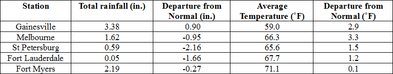
Table 2: December precipitation totals and departures from normal (inches) for selected cities.
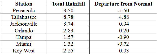
Table 3: Select daily rainfall records (inches) broken during December. (Compiled from NOAA, NWS)
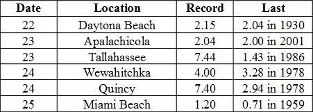
Figure 1: A graphical depiction of the monthly rainfall departure from normal (inches) for December is given in the figure below (courtesy of NOAA, NWS).
ENSO-Neutral Conditions Continue in the Pacific.
Based on current data and forecast models, the Climate Prediction Center (CPC) continue to have an El Niño Watch in place. Though Neutral ENSO conditions continue to be reported, positive sea surface temperatures (SST) anomalies have been recorded across most of the Pacific Ocean. An El Niño event is favored to develop during the Northern Hemisphere winter. CPC predicts below normal temperatures and above normal precipitation across the state through March 2015.
Hazardous Weather Events in December.
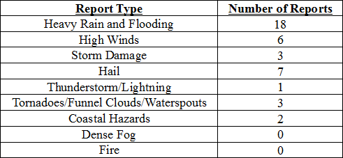
There were only 40 hazardous weather reports across the state in December. On December 8th, high winds (up to 50 mph) were reported along the eastern coast of Florida. High surf, up to 8 feet was reported around the area of St. Augustine and Vilano Beach. Waterspouts were reported offshore of Miami Beach, FL on the 13th. A lightning strike injured 11 people near Raymond James Stadium (Tampa, FL) on Dec 21st prior to a NFL Football game. Seven people were transported to the hospital, one of which was reported in critical condition, while four additional people went to the hospital on their own. A severe thunderstorm produced hail (pea to golf ball sized) in the Gainesville and Middleburg areas on the 22nd. On December 23rd, torrential heavy rains caused flooding in Tallahassee and Quincy, FL. Many roads in both locations were impassable due to standing water. In Defuniak Springs, a 10’ swath of water covered the southbound lanes of Highway 83, and floodwaters had closed roads in Walton County. After the front passed through, the combination of soggy ground and high winds caused trees to be knocked down in multiple Panhandle locations.
Table 4: Breakdown of storm reports submitted in Florida during the month of December (Compiled from Southeast Regional Climate Center.)
Agricultural and other climate related impacts.
At the beginning of December, cotton and soybean harvesting wrapped up in the Panhandle and north Florida. Farmers in the area began planting winter forage, oats and wheat for grain. The sugarcane harvest in Glades and Hendry counties continued, while vegetables harvesting in southwest Florida ramped up. Small amounts of rain and warmer weather improved pasture conditions and reduced cattle stress across portions of the state. Early orange harvest picked up significantly in the first part of the month, and the grapefruit harvest for both white and colored headed to plants for processing or to the fresh market. By mid-month, some U-pick strawberry fields had opened in Orange County, and spring vegetable planting began in Flagler and Putnam counties. Cattle and horse owners in southwest Florida were feeding hay to livestock, though pasture conditions were reported fair to good across Florida. Most of the early orange harvest was being used for juice and 13 out of 15 processing plants had opened and were beginning to run fruit. Heavy rains at the end of the month caused the fieldwork to be halted in the Panhandle, and the coldest temperature reported during that time was 34˚F in Walton County (Defuniak Springs). Sugarcane, strawberries, citrus, and vegetable harvests continued across the state. Harvesting totals for early oranges were down due to small sized fruits and the holidays. Citrus grove activity for the month included irrigation, mowing, aerial spraying, and fertilizing.
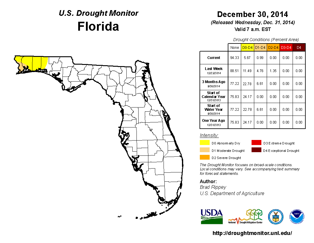
At the end of November, heavy rains across portions of the Panhandle and Big Bend reduced the moderate drought (D1) conditions to abnormally dry (D0) in Gadsden, Leon, Jefferson and Wakulla counties. Dry conditions over the first part of the month of December kept drought conditions consistent across the state. When the Drought Monitor was released on the 16th of the month, the D0 conditions were removed from Gadsden, Jefferson, Leon and Wakulla counties. Unfortunately, the rains that helped ease the drought conditions that had plagued that portion of the Big Bend for months did not help the northwestern Panhandle. The D0 conditions were seen in Bay, Holmes, Jackson and Washington counties, and D1 conditions expanded from the coastal area to interior portions of Escambia, Okaloosa and Santa Rosa counties. Severe drought (D2) was introduced in Escambia and Santa Rosa counties at mid-month. On December 23rd – 24th, a strong storm system moved through the northern part of the state, dumping 3.00” to 10.00” in the Panhandle and Big Bend. The rainfall caused localized flooding in some urbanized areas and some rivers and streams to rise. In addition, the rainfall reduced some of the drought impacts in the northwestern Panhandle counties. The remainder of the state saw monthly rainfall totals slightly below normal, though no drought conditions were posted during December.
Figure 2: Drought conditions in Florida as of December 31, 2014 (courtesy of U.S. Drought Monitor).
Appendix 1: Additional December Departures from Normal Data for Florida Locations
Appendix 2: Select daily maximum and minimum temperature records (o F) tied or broken during December. (Compiled from NOAA, NWS)