Prepared by Preston Leftwich, David F. Zierden, and Melissa Griffin
Florida Climate Center
The Florida State University
Tallahassee, FL

Most average temperatures near normal for December. Monthly average temperatures in December were near normal across most of the state (Table 1). Exceptions were Pensacola (2.4°F below normal) and Miami (3.1°F above normal). Numerous daily maximum temperature records were observed (Table 2). Among these, all-time highest temperatures for December were recorded at Miami (89°F on the 10th), Vero Beach (87°F on the 2nd) and West Palm Beach (90°F on the 9th). The all-time warmest temperature for December at Miami broke a record established in 1896.
Table 1: December average temperatures and departures from normal (°F) for selected cities.
| Station | Average Temperature | Departure from Normal |
| Pensacola | 51.7 | -2.4 |
| Tallahassee | 53.7 | 0.0 |
| Jacksonville | 56.3 | 1.3 |
| Orlando | 63.8 | 0.8 |
| Tampa | 63.2 | -0.1 |
| Miami | 73.0 | 3.1 |
| Key West | 73.4 | 1.4 |
Table 2: Maximum temperature (°F) records tied or set during December (compiled from NWS).
| Date | Station | Temperature | Previous Record |
| 2 | Melbourne | 85 | 84 in 1981 |
| 2 | Vero Beach | 87 ** | 85 in 2006 * |
| 9 | Daytona Beach | 85 t | 85 in 1978 |
| 9 | Lakeland | 85 t | 85 in 1986 * |
| 9 | Pensacola | 79 | 78 in 1986 |
| 9 | Vero Beach | 87 | 84 in 1997 |
| 9 | W. Palm Beach | 90 ** | 87 in 1948 |
| 10 | Ft. Lauderdale | 87 | 86 in 1997 |
| 10 | Key West | 84 t | 84 in 1993 |
| 10 | Miami | 89 ** | 86 in 1896 |
| 10 | Vero Beach | 85 t | 85 in 1978 |
| 10 | W. Palm Beach | 87 | 86 in 1997 |
| 13 | Vero Beach | 86 t | 86 in 1961 * |
| 14 | Lakeland | 84 t | 84 in 2001 |
| 15 | Jacksonville | 84 | 83 in 1972 |
| 15 | Miami | 85 | 83 in 2007 |
| t=tied *last of multiple occurrences **all-time highest for December | |||
December rainfall totals well above normal at northern, central, and east-coastal areas. Rainfall totals for December were more than three inches above normal in northern and central parts of the state, as well as several east-coastal areas (Table 3). Pensacola and Tallahassee were more than nine and six inches above normal, respectively. Numerous daily precipitation records were tied or set during December (Table 4). Several of these records had existed for many years. Of particular note, 5.74" on the 2nd at Tallahassee broke a daily record established in 1896, and 0.42" at Key West on the 5th broke a daily record established in 1886.
Table 3: December precipitation totals and departures from normal (inches) for selected cities.
| Station | Total Rainfall | Departure from Normal |
| Pensacola | 13.75 | 9.78 |
| Tallahassee | 10.92 | 6.82 |
| Jacksonville | 5.88 | 3.24 |
| Orlando | 5.39 | 3.08 |
| Tampa | 2.32 | 0.02 |
| Miami | 3.01 | 0.83 |
| Key West | 4.49 | 2.35 |
Table 4: Daily precipitation (inches) records tied or set during December (compiled from NWS)
| Date | Station | Amount | Previous Record |
| 2 | Apalachicola | 3.72 | 0.35 in 1985 |
| 2 | Tallahassee | 5.34 | 1.93 in 1896 |
| 4 | Daytona Beach | 1.61 | 1.17 in 1953 |
| 4 | Fort Myers | 2.17 | 1.22 in 1994 |
| 5 | Fort Myers | 0.82 | 0.50 in 1937 |
| 5 | Key West | 0.42 | 0.41 in 1886 |
| 15 | W. Palm Beach | 3.10 | 1.33 in 1958 |
| 18 | Ft. Lauderdale | 2.45 | 1.98 in 1917 |
| 18 | Key West | 3.28 | 1.90 in 1928 |
| 18 | Melbourne | 1.68 t | 1.68 in 1999 |
| 18 | Naples | 1.70 | 0.62 in 1954 |
| 18 | Vero Beach | 1.87 | 0.70 in 1999 |
| 18 | W. Palm Beach | 1.90 | 1.07 in 1923 |
| t=tied | |||
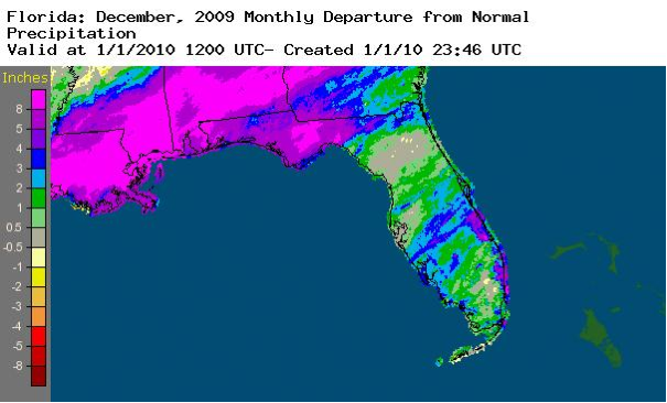
A graphical depiction of the monthly rainfall departure from normal (inches) for December is given in the figure below (courtesy of NOAA, NWS). Amounts of more than eight inches above normal are evident in the northwest.
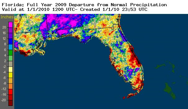
Also, a graphical depiction of annual rainfall departures from normal for 2009 is given in the Appendix.
El Niño continues to impact Florida. Sea surface temperatures in the equatorial Pacific Ocean remained above the 0.5°C threshold designating El Niño conditions during December. Florida weather fit well the conceptual model for winter El Niño climate patterns. Heaviest rainfall and several severe weather events occurred near surface low pressure systems associated with an active southern jet stream. Increased cloudiness often kept nighttime temperatures high, and eight high-minimum temperature records were set. In particular, the minimum temperature at Daytona Beach on the 9th (72°F) was the all-time high-minimum for December.
Hazardous weather. In the north, a tornado touched down near Crestview and wind damage occurred near Panama City, Jacobs and McAlpin on the 2nd. On the 9th, wind damage occurred near Chattahoochee and a tornado damaged houses near Tallahassee. Later in the month, tornadoes were observed near Homestead, Key West and Ona, as well as wind damage near Holoran, on the 18th. As a cold front pushed across north Florida, wind damage was reported near Ft. Walton Beach on the 24th and near Live Oak on the 25th.
Agricultural and other impacts. Persistent wet conditions from early in the month have hindered fieldwork in the north. Fall and winter plantings were also slowed by wet ground. Sugar cane harvest was active despite some delays due to locally heavy rain. A variety of winter vegetables were harvested, although wet conditions caused some disease and quality problems.
APPENDIX
A graphical depiction of the annual rainfall departure from normal (inches) for 2009 is given in the figure below (courtesy of NOAA, NWS).