Prepared by Preston Leftwich, David F. Zierden, and Melissa Griffin
Florida Climate Center
The Florida State University
Tallahassee, FL
Note: Beginning with this summary, comparisons to normal are based on values for the period 1981-2010.
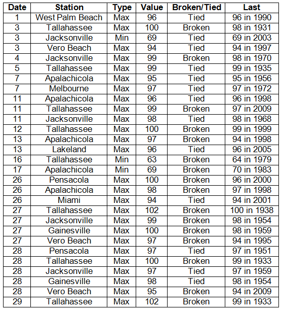
Average temperatures continue above normal in August. Average temperatures were well-above normal in the north during August (Table 1). At Tallahassee the average temperature of 85.1° F marked the warmest August on record. Numerous daily records were tied or broken in all parts of the state (Appendix). Daily maxima at Tallahassee reached at least 100° F seven times. Five of seven daily maximum records tied or broken at Tallahassee had been in existence since the 1930s. Both Apalachicola and Jacksonville set new daily maximum records on four days. In contrast, low temperatures of 69° F at Jacksonville on the 3rd, 63° F at Tallahassee on the 16th, and 69° F at Apalachicola on the 17th were daily minimum records.
Table 1: August average temperatures and departures from normal (° F) for selected cities.

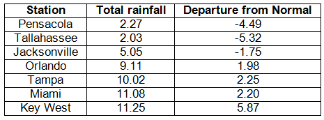
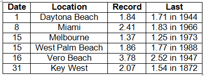
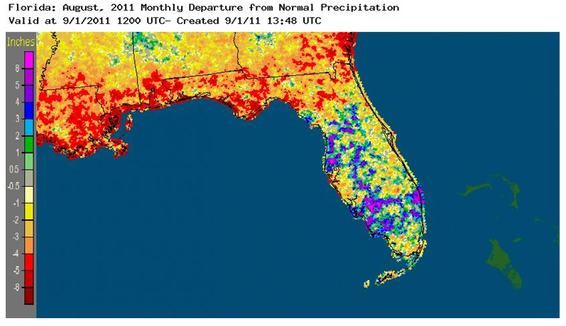
Rainfall totals vary during August. Rainfall totals varied greatly across the state during August (Table 2). In the north, monthly totals at Pensacola (2.27 inches) and Tallahassee (2.03 inches) were more than 5 and 5 inches below normal, respectively. It was the driest August on record at Tallahassee. In contrast, monthly totals in central and southern areas were generally above normal. Miami and Key West observed rainfall of more than 11 inches during the month. In addition, monthly totals at West Palm Beach and Vero Beach exceeded 11 inches, also. The monthly total at Key West was more than 5 inches above normal. Five daily rainfall records were broken. A daily total of 1.84 inches at Daytona Beach on the 1st broke a record in existence since 1944. A daily total of 3.78 inches at Vero Beach on the 16th broke a record in existence since 1947. Also, a daily total of 2.07 inches at Key West on the 31st broke a record in existence since 1872. Areal patterns of monthly rainfall relative to normal are depicted in Figure 1.
Table 2: August precipitation totals and departures from normal (inches) for selected cities.

Table 3: Daily rainfall records (inches) broken during August (compiled from NOAA, NWS).

Figure 1: A graphical depiction of the monthly rainfall departure from normal (inches) for August is given in the figure below (courtesy of NOAA, NWS).

ENSO continues in neutral phase during August. Sea surface temperatures in the equatorial Pacific Ocean continued near-normal during August, indicating a neutral phase of El Niño-Southern Oscillation (ENSO). A neutral phase of ENSO had no impact on weather across the state during August.
Hazardous weather. A weak tornado damaged roofs, blew out windows and caused tree damage along a path from Tamarac to North Lauderdale on the 2nd. On the 5th, a waterspout that moved onshore from a lake near Eustis damaged two roofs and downed power lines. Thunderstorms downed trees near Crescent City, St. Augustine, Callahan, Mandarin, Anthony and Hastings on the 12th. Two persons were injured when thunderstorm winds blew a tree onto a mobile home near Ocala on the 13th. On the 23rd, thunderstorm winds blew a tree across I-75 near Micanopy and damaged a mobile home near Chiefland. As Hurricane Irene passed well offshore on the 25th, gusty winds and some heavy rain were recorded in immediate eastern coastal areas. Also, two persons drowned in high surf generated by Irene.
Agricultural and other impacts. High temperatures and continued dryness stressed cotton, peanuts and pasture in the Panhandle. Rain during the latter half of the month improved drought conditions in southeastern and southwestern areas. However, water restrictions remained in place in portions of the southeast.
Appendix: Daily maximum and minimum temperature records (° F) tied or broken during August (compiled from NOAA, NWS).


