
Prepared by David F. Zierden and Melissa Griffin
Florida Climate Center
The Florida State University
Tallahassee, FL
Temperatures near normal for April. Most of Florida experience near-normal temperatures during the month of April, with the exception of South Florida and West-Central Florida, which were 1-2 degrees warmer than normal. Only one significant cold front impacted the state, bring much colder than normal temperatures during the five day stretch of April 5th through the 10th from North Florida and the Panhandle all the way down to extreme South Florida. The coldest temperatures were recorded early morning on April 8th with weather stations at Cross City, Perry, and Tallahassee recording the low temperature of 31 degrees. From April 11th through the remainder of the month, daily temperatures generally ranged from near normal to slightly above normal as high pressure and southerly winds dominated our weather patterns.
| Station | Average Temperature | Departure from Normal |
| Pensacola | 66.1 | 0.0 |
| Tallahassee | 67.1 | 0.7 |
| Jacksonville | 66.6 | 0.0 |
| Orlando | 71.5 | 0.0 |
| Tampa | 73.8 | 2.2 |
| Miami | 77.0 | 1.3 |
| Key West | 76.9 | -0.1 |
Table 1: April average temperatures and departures from normal for selected cities (degrees F.).
Unusually active weather pattern brings frequent torrential rains to North Florida. The last week of March and first week of April brought a shift in the large-scale weather patterns across the Southeast U.S., characterized by an active pattern with frequent low pressure systems moving across the northern Gulf Coast. Several of these systems were slow-moving, allowing soaking rains and thunderstorms to dump heavy accumulations of rain over the two-week period across most of Georgia, Alabama, and North Florida. A large swath of the Florida Panhandle, South Alabama, and South Georgia received over 12 inches during the last week of March and the first week of April with a greater area seeing 6-8 inches. The widespread nature of the heavy rainfall resulted in flooding of low-lying or poorly-drained areas and record or near-record floods on some Georgia and North Florida Rivers.
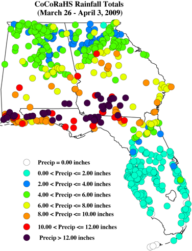
Rainfall total for late March/early April from CoCoRaHS observations (volunteer observers).
The State was hit by one final rain system on April 13th-14th that dumped another 2-4 inches across the Panhandle, but amounts generally one inch or less from Jacksonville down through the Tampa area.
Unfortunately, these torrential rains failed to progress down the peninsula where the driest areas of the State are located. South of a diagonal line from Gainesville to St. Augustine, the peninsula received only 1-2 inches during the month of April and continued the string of months with below-normal rainfall. The South Florida Water Management District reports the driest 6-month period on record (since 1932) for their management area from November through April.
| Station | Total Rainfall | Departure from Normal |
| Pensacola * | 1.73 | -3.33 |
| Tallahassee | 10.18 | 6.59 |
| Jacksonville | 5.90 | 2.76 |
| Orlando | 1.06 | -1.36 |
| Tampa | 1.22 | -0.58 |
| Miami | 1.17 | -2.19 |
| Key West | 0.70 | -1.36 |
Table 2: April precipitation totals and departures from normal for selected cities (inches).
* Pensacola totals are low because the rain event on April 1st missed the near coastal area (where the rain gauge is located) while dumping 6-8 inches just a few miles inland.Pacific Ocean impacts on the climate. La Niña, a condition of colder than normal sea surface temperatures in the equatorial Pacific Ocean, began to break up in the month of March and has since dissipated. La Niña is known to bring warm and dry winters to Florida and the Southeast. Ocean temperatures have warmed to near-normal in the past month near the Pacific equator and the atmosphere over the region is now behaving like neutral conditions. A return to Neutral conditions in the Pacific Ocean means that the remainder of spring and early summer will have no predisposition towards either wetter, drier, warmer, or colder than normal climate patterns.
Major flooding on north Florida rivers. The progression of weather systems in late March/early April producing heavy rainfall across north Florida, Alabama, and Georgia resulted in major flooding in low-lying areas and record or near record heights on area rivers. Below are some of the recorded river crests from the NWS Southeast River Forecast Center:
Pinetta Florida on the Withlacoochee River - Record Flood
- Pinetta crested at a new record of 88.51 feet on April 6. The old record was 85.05 on April 5th 1948.
Ellaville Florida on the Suwannee River - Major Flood
- Ellaville crested at a level of 63.8 feet on April 10th. Florida Department of Transportation was forced to close U.S. highways 84 and 90 and Interstate 10 was also threatened.
Havana Florida on the Ochlockonee River - Major Flood
- Havanna crested at 33.45 feet, a major flood, and just under the 2nd highest flood on record. The 2nd highest flood on record was 33.71 feet.
Altha Florida on the Chipola River - Major Flood
- Altha crested at 30.66 feet with the 4th highest level on record.
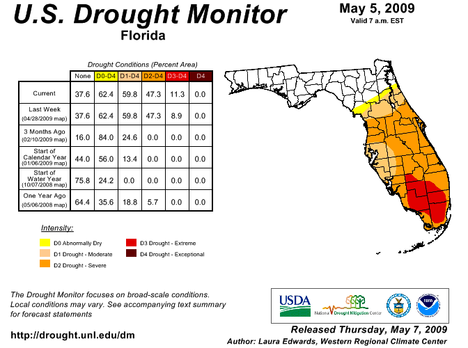
Drought impacts. As stated above, the heavy rains of late March/early April failed to penetrate down the peninsula south of Gainesville. With winter rainfall deficits from 5 to 10 inches, drought continues to worsen across central and south Florida. According to the U. S. Drought Monitor, most of the peninsula is now classified as being in moderate or severe drought, with interior Southwest Florida as extreme. Fortunately, Lake Okeechobee levels are higher this year (due to tropical storm Faye) heading into the critical spring period than they were during the last drought years of 2007 and 2008. The big lake is a critical resource for municipal and agricultural water supply in south Florida.
The Southwest Florida Water Management district has restricted watering of lawns to once per week across the entire district with stricter restriction in Pinellas, Pasco, and Hillsborough counties. Tampa Bay Water (serving 6 municipalities in the area) has exhausted the Bill Young reservoir and is not withdrawing from the Hillsborough or Alafia rivers due to record low flows. The South Florida Water Management District is proposing year-round watering restriction to help mitigate recurring water shortages.
Impacts on agriculture and forestry. The heavy rains across north Florida have delayed field work for row crops such as corn and peanuts. Fields prepared for planting were flooded and some reported soil erosion. The pasture condition was limited by cold and flooding in the Panhandle and northern counties and by drought in the central and southwest counties.
The dry weather superimposed on the peninsula's typical dry winter season has forests and fuels dangerously dry for wildfire potential. The Florida Division of Forestry reports that portions of central and south Florida have Keetch-Byram Drought Index (KBDI) values over 700 corresponding to a severe threat. Persistent brush fires in Southwest Florida have resulted in the nightly closing of I-75 due to reduced visibilities.
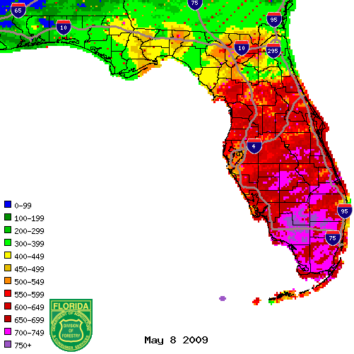
Figure 1: KBDI values from radar-derived precipitation estimates (Courtesy of FL DOF).