Prepared by Florida Climate Center
The Florida State University
Tallahassee, FL

Key Points:
- Monthly average temperature departures in November were above normal across the state.
- Monthly precipitation was variable, with surplus rainfall in central and northeast Florida due to Hurricane Nicole and below normal rainfall in the Panhandle.
- Drought conditions persisted across the Panhandle throughout the month, with about 30% of the state in either severe drought (D2) or moderate drought (D1) at the end of the month.
- We are entering the third winter in a row with a La Niña Advisory, with a 57% chance for a transition to ENSO-neutral during February-April 2023.
Average monthly temperatures in November were above normal across the state. Average temperature departures from normal ranged from +2.7 ̊F in Key West to +5.1 ̊F in Fort Myers for the month (see Table 1 and Appendix 1 for select cities). Many locations had one of their top five warmest Novembers on record, including Miami (2nd-warmest), Naples (2nd-warmest), Fort Myers (3rd-warmest), Orlando (4th-warmest), Vero Beach (4th-warmest), and Key West (5th-warmest). The month started out warmer than normal, about 2-5 degrees above average through the 11th. The last week of the month was also warmer than average, with places in south Florida experiencing record warm temperatures. Select daily high maximum temperature records tied or broken during the month are provided in Appendix 2.
Table 1. November average temperatures and departures from normal ( ̊F) for selected cities.
| Station | Mean Temperature | Departure from Normal |
| Pensacola | 64.6 | +3.2 |
| Tallahassee | 64.3 | +4.1 |
| Jacksonville | 65.8 | +3.5 |
| Orlando | 72.8 | +4.6 |
| Tampa | 72.6 | +2.8 |
| Miami | 78.9 | +4.1 |
| Key West | 79.3 | +2.7 |
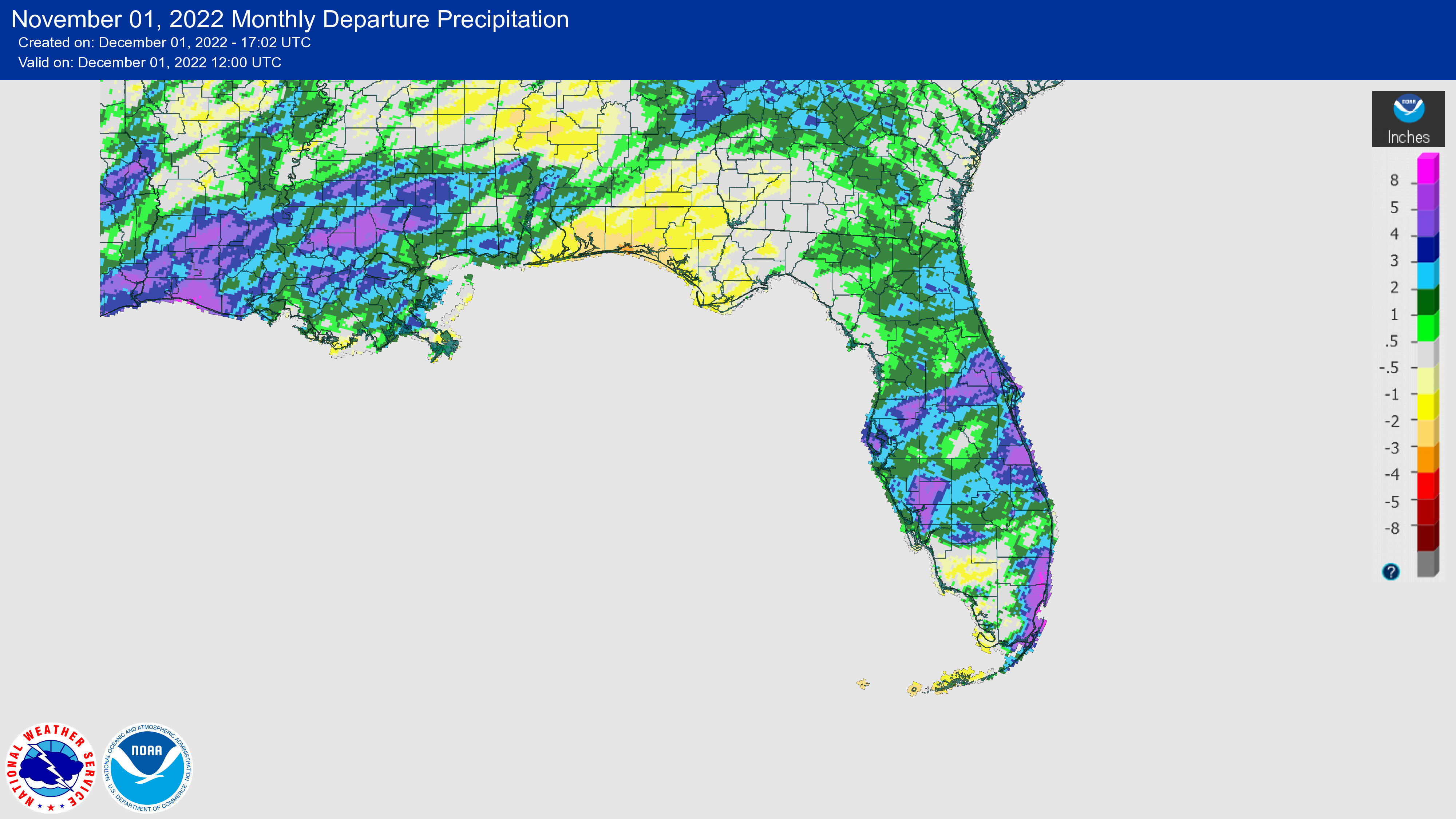
Monthly rainfall totals in November were below normal in the Panhandle and above normal in much of the rest of the state. The monthly precipitation departures from normal ranged from -1.71 inches in Pensacola to +4.96 inches in Miami (see Table 2 and Appendix 1 for additional locations). Hurricane Nicole brought over 5 inches of rain in areas of east-central, central, and west-central Florida on the 10th. The heaviest rain from Nicole occurred in the Tampa to Daytona Beach corridor with some stations receiving as much as 8 inches of rain. The storm made a second landfall just northwest of Cedar Key but did not produce significant rain in the Panhandle. Continued dryness in the Panhandle led to deteriorating conditions and the expansion of moderate drought during the month (see drought section below). Annual precipitation surpluses in Pensacola and Tallahassee continue to shrink due to below-normal rainfall over the past few months, now at just +0.6 and +1.7 inches above normal for the year, respectively.
Table 2. November precipitation totals and departures from normal (inches) for selected cities.
| Station | Total Rainfall | Departure from Normal |
| Pensacola | 2.71 | -1.71 |
| Tallahassee | 2.47 | -0.63 |
| Jacksonville | 3.02 | +1.02 |
| Orlando | 4.27 | +2.48 |
| Tampa | 5.18 | +3.78 |
| Miami | 8.49 | +4.96 |
| Key West | 1.40 | -0.65 |
Figure 1. A graphical depiction of the monthly rainfall departure from normal (inches) for November (courtesy of NOAA, NWS).
La Niña Advisory.
La Niña is expected to continue through the Northern Hemisphere winter, with a 76% chance it will persist for the third year in a row (from December-February). There is a 57% chance for a transition to ENSO-neutral conditions during February-April 2023 (up from 53% since the last ENSO update). Below average sea surface temperatures have stayed consistent in the eastern equatorial Pacific Ocean since late July, and overall the coupled ocean-atmosphere system continues to reflect La Niña. The next ENSO update is scheduled for December 8, 2022.
Hazardous Weather Events in November.
According to the Local Storm Reports issued by the local National Weather Service offices serving Florida, there were 443 individual local reports of hazardous weather events recorded across the state during the month of November, which includes reports and rainfall totals from Hurricane Nicole (see Table 4 for a breakdown by event type). Nicole made landfall as a category 1 hurricane on November 10 near Vero Beach with maximum sustained winds of 75 mph. It then moved through central Florida, briefly emerged in the Gulf of Mexico, and made a second landfall later that day just northwest of Cedar Key in the Big Bend region. Nicole brought high winds, high surf, tidal and storm surge flooding, heavy rainfall, and significant beach erosion particularly in areas previously impacted by Hurricane Ian. The storm caused power outages, significant infrastructure damage, and some severe weather. Coastal erosion undermined homes and other structures in Velano Beach, New Smyrna Beach, and Daytona Beach. Overwash from storm surge led to the closure of A1A in parts of St. Johns and Broward Counties. Downed power lines led to two fatalities in Orange County. Several water rescues occurred due to storm surge flooding.
Table 4. Breakdown of storm reports submitted in Florida during the month of November (compiled from Iowa State University/Iowa Environmental Mesonet).
| Report Type | Number of Reports |
| Heavy Rain | 23 |
| Flood | 4 |
| Coastal Flood | 2 |
| Hail | 1 |
| Marine Thunderstorm Wind | 1 |
| Non-Thunderstorm Wind Gust | 0 |
| Non-Thunderstorm Wind Damage | 0 |
| Tornado/Waterspout/Funnel Cloud | 4/6/1 |
| Thunderstorm Wind Damage | 1 |
| Thunderstorm Wind Gust | 10 |
| Tropical Storm | 249 |
| Hurricane | 8 |
| High Surf | 1 |
| Storm Surge | 68 |
Daily Record Events in November.
Table 5.Summary of daily records broken or set in Florida in November (source: NCEI Daily Weather Records).
| Category | Number of Records |
| Highest daily max. temp. | 65 |
| Highest daily min. temp. | 51 |
| Lowest daily max. temp. | 6 |
| Lowest daily min. temp. | 0 |
| Highest daily precipitation | 38 |
| Total | 160 |
Weather/Climate Highlight of the Month: Hurricane Nicole
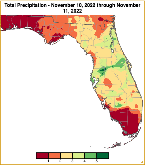
Nicole was a category 1 hurricane when it made landfall along Florida’s Atlantic coast near Vero Beach, and it was a tropical storm when it made a second landfall along the Gulf Coast just west of Cedar Key. Nicole became the 3rd hurricane on record to make landfall in Florida in November. It was the first hurricane to strike Florida in the month of November in 37 years (since Hurricane Kate in 1985). The storm coincided with the time of high tide, exacerbating coastal flooding in some areas and contributing to severe coastal erosion in places previously impacted by Hurricane Ian. Rainfall totals from the storm varied from a couple of inches to over 6 inches in central Florida, according to CoCoRaHS and gridded precipitation data (see Appendix 3). Nicole has delayed drainage of the St. Johns River and now many areas are expected to remain in flood stage through December, prolonging recovery. At least five fatalities have been linked to Nicole and preliminary damage estimates are in excess of $500 million.
Drought-Related Impacts.
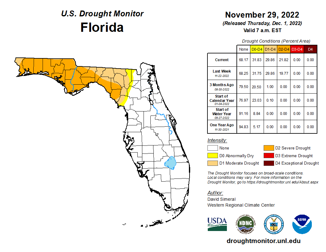
By the middle of November, drought had expanded across the Panhandle and extended east to parts of Levy, Gilchrist, and Columbia counties. About 20% of the area was in severe drought (D2) and 10% was in moderate drought (D1), according to the U.S. Drought Monitor. By the end of the month, 22% of the state was in severe drought (D2), 8% was in moderate drought (D1), and 2% was abnormally dry (D0) (Figure 2 below).
As of November 30, the Lake Okeechobee water level was 16.51 ft. above sea level (Feet-NGVD29), which is above average for this time of the year. The water level continued to rise during the month and has rebounded remarkably by nearly 4 feet since early September. At the first of the month, the water level was 15.87 ft. above sea level.
Figure 2. A graphical depiction of the current drought conditions in Florida according to the U.S. Drought Monitor (courtesy of the National Drought Mitigation Center, University of Nebraska-Lincoln).
Agriculture-Related Impacts.
In mid-November, topsoil moisture conditions were adequate in 66% of the state, short in 13%, and very short in 1% of the state, while 20% of the state was in surplus. At the end of November, topsoil moisture levels were adequate in 74% of the state, short in 17% of the state, and 9% of the state was in surplus. For more information, consult the Crop Progress and Conditions report, which is published by the USDA's National Agricultural Statistics Service.
Appendix 1
Additional November departures from normal data for select Florida locations (Source: NWS).
| Station | Average Temperature (˚F) | Departure from Normal (˚F) | Total Rainfall (in.) | Departure from Normal (in.) |
| Gainesville | 67.0 | +4.3 | 3.95 | +2.16 |
| Sarasota | 73.1 | +3.0 | 2.63 | +0.82 |
| Melbourne | 73.7 | +3.0 | 6.03 | +3.48 |
| Fort Myers | 76.6 | +5.1 | 1.98 | +0.20 |
| West Palm Beach | 77.5 | +4.5 | 6.10 | +2.48 |
Appendix 2
Select daily record high maximum temperatures (°F) broken or tied during November (compiled from NOAA).
| Location | Date | Record | Broken/Tied | Last |
| Miles City | 1 | 94 | Tied | 94 in 2020 |
| Orlando | 1 | 90 | Broken | 89 in 2013 |
| Fort Myers | 1 | 92 | Broken | 91 in 2019 |
| Lakeland | 1 | 90 | Broken | 89 in 1986 |
| Clermont | 2 | 91 | Tied | 91 in 2015 |
| Plant City | 2 | 92 | Broken | 90 in 1971 |
| Venice | 2 | 90 | Broken | 89 in 1995 |
| Cross City | 2 | 89 | Broken | 88 in 2015 |
| Fort Myers | 2 | 92 | Broken | 91 in 2019 |
| Miami | 2 | 90 | Broken | 89 in 2019 |
| Tampa | 2 | 90 | Broken | 89 in 1972 |
| Key West | 2 | 93 | Broken | 88 in 2019 |
| Plant City | 3 | 93 | Broken | 90 in 1972 |
| Fort Myers | 3 | 91 | Broken | 90 in 2015 |
| Key West | 3 | 93 | Broken | 88 in 1994 |
| Crestview | 6 | 89 | Broken | 87 in 2003 |
| Cross City | 7 | 88 | Broken | 87 in 2003 |
| Lake City | 7 | 87 | Broken | 86 in 2000 |
| Marianna | 7 | 87 | Broken | 85 in 2017 |
| Crestview | 7 | 90 | Broken | 84 in 2016 |
| Pensacola | 7 | 85 | Broken | 83 in 2005 |
| Tallahassee | 7 | 88 | Broken | 86 in 2015 |
| Naples | 8 | 90 | Tied | 90 in 2015 |
| Niceville | 8 | 86 | Broken | 81 in 2018 |
| Marianna | 8 | 88 | Broken | 86 in 2000 |
| Crestview | 8 | 90 | Broken | 84 in 2005 |
| Pensacola | 8 | 89 | Broken | 85 in 2020 |
| Niceville | 9 | 86 | Broken | 82 in 2020 |
| Key West | 11 | 92 | Broken | 88 in 2020 |
| Vero Beach | 17 | 86 | Broken | 85 in 1993 |
| Key West | 24 | 92 | Broken | 89 in 2020 |
| Miami | 25 | 88 | Broken | 85 in 2014 |
| Vero Beach | 25 | 87 | Broken | 85 in 1992 |
| Orlando | 25 | 85 | Broken | 84 in 2016 |
| Perrine | 26 | 88 | Broken | 87 in 2014 |
| Ochopee | 26 | 89 | Broken | 87 in 2000 |
| Orlando | 27 | 86 | Broken | 85 in 1988 |
| Miami | 27 | 89 | Broken | 86 in 1948 |
| Fort Lauderdale | 28 | 88 | Tied | 88 in 1958 |
| Perrine | 29 | 86 | Broken | 85 in 2019 |
| Miles City | 30 | 89 | Broken | 88 in 2010 |
| Key West | 30 | 92 | Broken | 89 in 2020 |
Appendix 3
Hurricane Nicole rainfall totals from November 10-11, 2022, based on NRCC hi-resolution data (radar or model guided 5 km gridded data).