|
|
|
The average number of thunderstorm days each year throughout the U.S. Courtesy of the National Weather Service. |
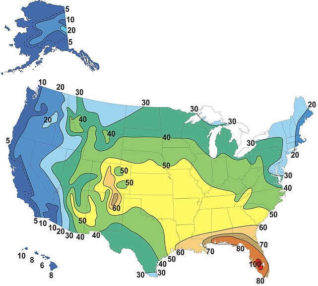
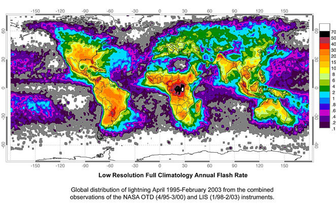
Virtually all summer rainstorms are accompanied by thunder and lightning. No other part of the nation has more thunderstorm activity than Florida. In the western half of the peninsula in a typical year, there are over 80 days with thunder and lightning. Central Florida's frequency of summer thunderstorms equals that of the world's maximum thunderstorm areas: Lake Victoria region of equatorial Africa and the middle of the Amazon basin. The Amazon and east African areas maintain their frequency of thunderstorm activity throughout most of the year, whereas the number of thunderstorms in Florida drops off sharply in the fall and does not pick back up until spring.
The simplest definition of a thunderstorm is a local storm that produces lightning and thunder. The storm itself can either be a single cumulonimbus cloud, a cluster of several thunderstorms, or a line of thunderstorms. In order for thunderstorms to form, there needs to be:
- Moisture - to form clouds and rain.
- Unstable air - warm air that can rise rapidly.
- Lift - cold or warm fronts, sea breezes, mountains or the sun's heat are capable of lifting air to help form thunderstorms.
Once all of these components are brought together, the thunderstorm then goes through a 3-stage life cycle:
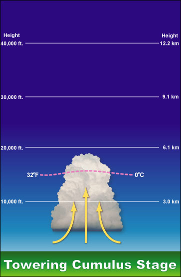
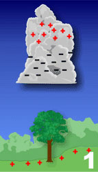
Development or Cumulus Stage: A cumulus cloud forms and begins to grow vertical, usually above 20,000 ft. Usually, little, if any, rain occurs during this stage. There might be occasional lightning.
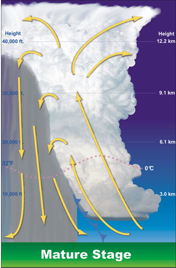
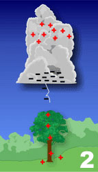
Mature Stage: The cloud has grown in considerable height, now in the range to 40,000 to 60,000 ft. Strong updrafts and downdrafts coexist within the storm. This is the most dangerous stage of the storm and is the most likely time for hail, heavy rain, lightning, strong winds and tornadoes. Storms occasionally have a black or dark green appearance.
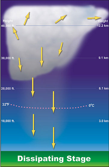
Dissipating Stage: The downdraft cuts off the updraft, which cuts off the supply of warm moist air to the storm and therefore, it dissipates. Rainfall decreases in intensity, along with winds, though strong gusts are still possible. Usually, the anvil top of the cloud is all that remains of the initial cumulus cloud.
Types of Thunderstorms
- Ordinary Cell: As the name implies, this is a thunderstorm with only one cell. It's commonly referred to a 'pulse' thunderstorm.
- Multi-cell Cluster: These are thunderstorms that are organized in clusters of 2-4 short-lived cells.
- Multi-cell Line: Some thunderstorms will form in a line which can extend laterally for hundreds or miles. These 'squall lines' can persist for hours and extend for hundreds of miles. Squall lines can be continuous or with breaks and include contiguous precipitation. Long-lived squall lines are known as "derechos" and can travel hundreds of miles, causing considerable damage along their path.
- Supercell Thunderstorms: These are potentially the most dangerous form of all thunderstorms types. Supercell thunderstorms have produced numerous long-lived strong and violent (EF2-EF5) tornaodes, along with damaging wind, hail and flash floods.
Thunderstorm Hazards
- Hail: Hail is a showery precipitation in the form of irregular pellets or balls of ice more than 5mm in diameter, falling from a cumulonimbus cloud. Hailstones are formed when updrafts carry raindrops up into the highest parts of the cloud and the super-cooled liquid droplets collide. Hail drops back down into the warmer part of the cloud and carried back up, until the internal up and downdrafts can no longer support the size of the hailstone, then it falls to the ground.
Hail size typically refers to the diameter of the hailstones. To make it easier to report, the following descriptions are often used:
Description Diameter (inches) Pea 0.25 Marble or Mothball 0.50 Penny or Dime 0.75 Nickel 0.88 Quarter 1.00 Half Dollar 1.25 Ping Pong Ball 1.50 Golfball 1.75 Hen's Egg 2.00 Tennis Ball 2.50 Baseball 2.75 Tea Cup 3.00 Grapefruit 4.00 Softball 4.50 So, why does Florida have so many thunderstorms, but not that many instances of hail? The freezing level in a Florida thunderstorm is so high; hail often melts before it reaches the ground. Even though hail is not common to the state, there have been about a dozen events of hail of over 3 inches being reported in Florida.
One event in 1996 in Lake Wales, hail as big as softballs was reported. Damage to the area was done to windows, roves and cars totaling $24 million. In 2007, the area of Kendrick (North of Ocala) reported hailstones ranging in size from 2 to 4 inches.
- Wind: Damaging winds are more likely to be associated with thunderstorms than tornadoes. In fact, many confuse damage produced by "straight-line" winds and often erroneously attribute it to tornadoes. The source of the damaging winds is the downdraft within the thunderstorm. A downdraft is a column of cool air that rapidly sinks to the ground that is usually accompanied by precipitation in a thunderstorm.
Downdrafts can cause downburst, which can be further classified as either microbursts or macro bursts.
A downburst is a strong downdraft current of air from a cumulonimbus clouds and is often associated with intense thunderstorms.
- Microburst: A downdraft that can affect an area of less than 2½ miles wide with peak winds lasting less than 5 minutes.
- Macroburst: A downdraft that can affect an area of at least 2½ miles wide and with peak winds lasting between 5 and 20 minutes. Intense macrobursts may cause tornado-force damage of up to F3 intensity.
- Tornadoes: See the Florida tornadoes section.
- Flash Floods: Except for heat related fatalities, more deaths occur due to flooding than from any other hazard. The main reason is because people underestimate the power and force of water. The effects of flooding can be felt on local, state and even regional scales. In Florida, flooding occurs frequently, but most of the floods are minor. However, Floridians must be careful because even minor floods can cause many deaths.
Floods are caused by rain, but flooding is more about how much rain falls, how fast it falls, and what happens to the rain after it hits the ground. The most common type of flood that happens during a thunderstorm is a flash flood. Most flash floods are caused be slow moving thunderstorms, thunderstorms that repeatedly move over the same area, or heavy rains from a tropical storm or hurricane. These floods can develop quickly depending on the intensity and duration of the storm, the topography of the area, soil conditions and ground cover.
- Lightning: Lightning is the most lethal component of the thunderstorm. While the conditions needed to produce lightning are understood, how lightning forms has never been verified. Forecasters may never able to forecast when and where a lightning strike will take place.
Florida is the lightning capital of the country, mainly due to our geography. The very elements that make our state a great place for outdoor activities -- warm temperatures and plenty of water -- also make the environment primed for the production of thunderstorms, which generate lightning.
Lightning develops during the violent circulation of air within the cumulonimbus cloud. The friction causes the positive and negative charges within the storm to separate. In addition, an electrical field develops between the base of the cloud and the ground. However, the electrical field in the cloud is stronger and most of the lightning (~75%) is contained within the cloud.
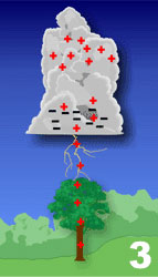
As the difference in the charge continues to increase, positively charged particles will rise up in taller objects, such as trees, telephone poles, and even buildings. A channel of negative charge, called a stepped ladder, will descend from the bottom of the storm cloud toward the ground. This is invisible to the human eye.
The positive charge that has collected in the tall object on the ground 'reaches' out to the approaching negative charge with its own channel, called a streamer. When these channels connect, the resulting electrical transfer is what we see as lightning. If enough of the charger is leftover, additional strokes will use the same channel and give the bolt the appearance of flickering. Lightning heats up the air to 50,000 degrees Fahrenheit, and this rapid heating of the air produces a shockwave that results in thunder.
Lightning has both negative and positive polarities. Most lightning forms at the bottom of the cloud, though less than 5% of all lightning occurs from the top of the anvil, making it a positive lightning strike. Positive lightning is very dangerous for several reasons. Since it comes from the top of the anvil cloud, the electric field is much stronger than a negative strike (almost ten times greater!). Some positive strikes can strike the ground beneath the cloud; however, most positive strikes occur near the edge of the cloud or can strike more than 10 miles away. Positive lightning is often responsible for the phenomenon commonly referred to as a "bolt from the blue". Positive strikes are more lethal and cause greater damage than negative lightning.
|
|
|
The global average annual occurrence of lightning, April 1995-February 2003. Courtesy of the National Weather Service. |