Prepared by Preston Leftwich, David F. Zierden, and Melissa Griffin
Florida Climate Center
The Florida State University
Tallahassee, FL

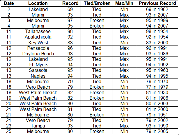
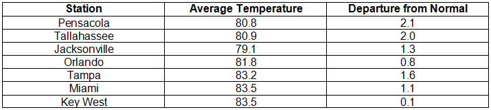
Average temperatures above normal for September. Persistent subtropical high pressure during the first three weeks of the month led to average temperatures remaining above normal for September (Table 1). The monthly mean of 84.1° F at West Palm Beach broke the record of 83.3° F recorded in 1951. Several maximum temperature records were tied or broken (Appendix). On the 11th, Apalachicola (92° F) and Tallahassee (98° F) tied daily maximum records in existence since 1954. For four consecutive days, the 18th through the 21st, West Palm Beach tied or broke daily records for highest minimum temperature, with 82o F on the 18th breaking a record in existence since 1930. The minimum temperature (80° F) at Melbourne on the 21st broke a record in existence since 1951.
Table 1: September average temperatures and departures from normal (° F) for selected cities.
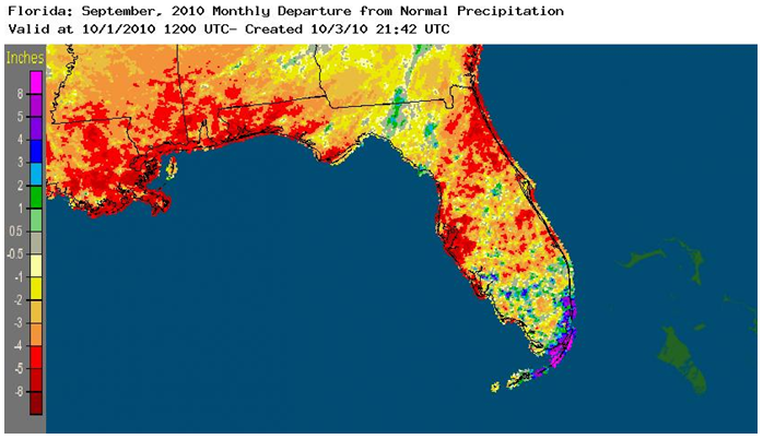
September rainfall totals vary around the state. Monthly rainfall in September was below normal in most areas except the south. Pensacola (0.62 in) and Tampa (1.13 in) were more than five inches below normal (Table 2). In contrast, Miami (15.89 in) was more than seven inches above normal. Localized heavy rain produced isolated record daily amounts (Table 3). Figure 1 provides an aerial depiction of both the well-below normal rainfall in northwest and north-central areas and the well-above normal rainfall in the extreme southeast.
Table 2: September precipitation totals and departures from normal (inches) for selected cities.
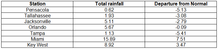
Table 3: Daily maximum rainfall records set in September
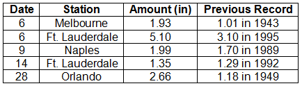
Figure 1: A graphical depiction of the monthly rainfall departure from normal (inches) for September is given in the figure below (courtesy of NOAA, NWS).
La Nina continues to strengthen during September. Sea surface temperatures in the equatorial Pacific Ocean continued below normal during September, clearly denoting a cold phase of ENSO, or La Nina. Increased tropical cyclone activity in the Atlantic basin, as seen during September, is associated with La Nina conditions. Also, the warm, dry conditions across most of the state are also associated with La Nina.
Hazardous weather. No tornadoes were observed during September. Thunderstorm winds produced only isolated damage in northern and central areas. On the 5th, thunderstorms produced wind gusts up to 69 mph near Cape Canaveral. As the remnants of Tropical Storm Nicole passed near southeastern coastal areas on the 29th, heavy rain was observed from Miami to Marathon.
Agricultural and other impacts. Dry conditions in western areas of the Panhandle have hindered peanut digging, stressed cotton and soybeans, and lowered hay yields. By the end of the month, areas in the western Panhandle along the border with Alabama reached severe drought conditions. Other areas in the northwest and along the northeast Atlantic coast have moderate drought conditions. Most northern areas have become abnormally dry. In contrast, growing conditions remained good in citrus areas throughout the month.
Appendix: Temperature Records (° F) Tied or Broken during September (compiled from NWS).