Prepared by Preston Leftwich, David F. Zierden, and Melissa Griffin
Florida Climate Center
The Florida State University
Tallahassee, FL

Temperatures near normal for November. Monthly average temperatures in November were near normal (Table 1). Early in the month a daily maximum temperature record was tied at Melbourne ( 87 °F on the 1st) and set at Miami ( 89 °F on the 3rd). After a strong cold front moved down the peninsula on the 26th, minimum temperatures across north Florida dipped into the 30s, with Tallahassee (31 °F) falling just below freezing on the 27th. The minimum temperature at Orlando was 20 °F below the daily normal on the 27th. Along the Atlantic coast minimum temperatures were more than 25 °F below the daily normal at Melbourne and Daytona Beach on the 28th.
Table 1: November average temperatures and departures from normal (°F) for selected cities.
| Station | Average Temperature | Departure from Normal |
| Pensacola | 59.6 | -1.1 |
| Tallahassee | 59.0 | -1.4 |
| Jacksonville | 62.3 | 0.6 |
| Orlando | 67.9 | 0.9 |
| Tampa | 68.9 | -0.4 |
| Miami | 75.7 | 1.3 |
| Key West | 75.9 | -0.4 |
November rainfall totals generally near or below normal. Rainfall totals for November were slightly below normal across most of the state (Table 2). However, daily precipitation records were set at Vero Beach (2.63" on the 3rd), Gainesville (1.21" on the 25th), and Key West (5.05" on the 26th). The monthly rainfall departure from normal at Key West (3.99") resulted mainly from the one-day record total.
Table 2: November precipitation totals and departures from normal (inches) for selected cities.
| Station | Total Rainfall | Departure from Normal |
| Pensacola | 4.85 | 0.39 |
| Tallahassee | 2.27 | -1.59 |
| Jacksonville | 0.85 | -1.49 |
| Orlando | 0.60 | -2.43 |
| Tampa | 2.82 | 1.20 |
| Miami | 2.97 | -0.46 |
| Key West | 6.63 | 3.99 |
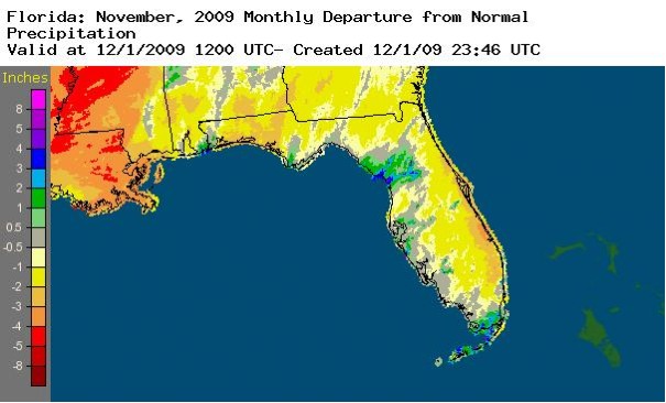
A graphical depiction of the monthly rainfall departure from normal for November is given in the figure below (courtesy of NOAA NWS). Departures range from over three inches above normal in the Keys and isolated locations in north central Florida to more than three inches below normal at some locations near the Atlantic coast.
El Niño continues in the Pacific Ocean. Sea surface temperatures in the equatorial Pacific Ocean continued to warm and remain above the 0.5 °C threshold designating El Niño conditions. Continuation of these above-normal sea surface temperatures during November and numerical model forecasts indicate El Niño will persist through the Northern Hemisphere winter.
Hazardous weather. After reaching Category 2 hurricane intensity in the Gulf of Mexico, Ida made landfall as a tropical storm just to the west of the Florida/Alabama border on November 10. Ida was the second latest hurricane to move through the Gulf of Mexico and affect North Florida. Although wind gusts greater than 40 miles per hour were observed at Pensacola on the 10th and storm total rainfall was greater than four inches at several places in northwest Florida, overall impacts of Ida were minimal.
Agricultural and other impacts. After a brief delay due to rainfall from Tropical Storm Ida, drier weather allowed the peanut harvest in the North to be near completion by the end of the month. Rainfall from Tropical Storm Ida improved pasture soil moisture in the Panhandle, but cooler temperatures slowed growth. Generally dry weather across the Peninsula allowed planting and some harvesting of vegetables in central and southern Florida.