Date: September 9, 2026
Prepared by: Dr. Emily Powell, State Climatologist for Florida
El Niño is on pace to become a very strong and possibly record strong event.
El Niño conditions emerged in June 2026 and water temperatures in the equatorial Pacific Ocean have been warming at a record pace ever since. El Niño refers to unusually warm surface waters along the equator in the central and eastern Pacific Ocean and can be thought of as the opposite of a La Niña, which brings unusually cool surface waters along this same region of the Pacific Ocean. Both the El Niño and La Niña phases of the El Niño Southern Oscillation (ENSO) have dramatic impacts on the climate patterns of the Southeast U.S. and in regions around the world. An El Niño is known to trigger fall, winter, and spring climate patterns that are wetter and cooler than normal over much of the Southeast U.S., being felt strongest over the peninsula of Florida, but also impacting much of the northern Gulf Coast, coastal Carolinas, and South Georgia.An El Niño or La Niña event occurs generally every few years and is commonly measured by sea surface temperatures; however, these events actually reflect a coupled ocean-atmospheric phenomenon that leads to changes in climate and weather patterns. A very strong El Niño is defined when average sea surface temperature (SST) anomalies in the Niño-3.4 index region (5°N–5°S, 120°–170°W) reach a threshold of +2.0°C or greater. Learn more about ENSO and its effects here.
This year’s El Niño has already exceeded records for this point in the year, compared to previous El Niño events since 1950. SSTs in the main monitoring region soared to +2.9°C warmer than normal in early September, a record for this time of year and outpacing the year-to-date SSTs during the very strong 2015-2016 and 1997-1998 events.
A very strong El Niño greatly increases the odds for a cool and wet winter in Florida and the Southeast, but still does not guarantee typical or worse impacts.
El Niño’s impacts are most pronounced during cool season months when the subtropical jet stream is stronger and exerts a greater influence on weather patterns across the southern U.S. While El Niño’s impacts will likely mature in November and December, it has already exerted a strong influence on the current hurricane season – both toward a very active Pacific Basin and below-average activity in the Atlantic Basin. Different measures show that vertical wind shear has been at very high levels over the Atlantic and Caribbean for much of this season.
With much warmer than normal ocean waters in place in the tropical Pacific Ocean, it is certain (100% chance) that El Niño will persist through the 2026-2027 winter and likely into the spring season (82% chance during March – May) before dissipating, which follows the typical life cycle. The official outlook from the Climate Prediction Center shows that the event is expected to peak around November 2026. Relative SST anomalies averaged across the Niño-index monitoring regions have continued to increase since El Niño emerged.

Pacific Ocean sea surface temperature anomalies as of September 9, 2026.
Major Shifts in Fall and Winter Likely.
While each El Niño looks different, an El Niño typically brings wetter weather to much of the region and a strong event increases those chances. During the winter, a more active southerly storm track pushes southward and intensifies over the peninsula of Florida where the threat of heavy rainfall and severe weather, including tornadoes, is noticeably higher. The reason for this can be attributed to the position and strength of the jet stream configuration that sets up during an El Niño. While the position of the jet stream will fluctuate with individual low pressure systems, fronts, and air masses, the preferred or average setup of the jet steam is that of a more zonal, or west to east, configuration that tends to steer winter storms across the southern tier of the U.S. and across the Southeast. Strong El Niño events (like this year) can push the wet and stormy signal further north and inland to cover much of Alabama, Georgia, and the Carolinas.
Average cool season (November – March) precipitation anomalies for previous strong El Niño events.
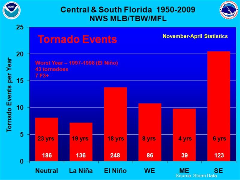
Number of tornado events by ENSO phase in Central and South Florida from 1950-2009. El Niño events are further grouped by weak (WE), moderate (ME), and strong (SE) El Niños. (Credit: National Weather Service)
El Niño precipitation could also bring big changes given that much of Florida has been entrenched in long-term drought. An unusually quiet hurricane season last year coupled with a dry fall and winter led to Florida experiencing its most widespread extreme drought in at least 25 years. Now as we're well into Florida’s wet season, drought conditions have improved but continue to linger in much of the state with significant long-term precipitation deficits and low streamflows that have made a return to normal conditions slow.
Summer precipitation was highly variable with hit-and-miss showers and thunderstorms, which is typical for summer convection. Much of Florida ended up with below normal precipitation for the summer as a whole (June-August), except parts of the eastern coast and central Panhandle, while the rest of the Southeast U.S. was also variable but on the whole closer to normal. The below normal Atlantic hurricane season so far this year has been a factor in below average rainfall in Florida. At peak hurricane season, there have been 5 tropical storms and no hurricanes in the Atlantic Basin, which is behind climatology for the number of named storms and number of hurricanes, including major hurricanes, for this point in the season (based on 1991-2020).

Departures from normal precipitation, in inches, for June through August 2026, from the High Plains Regional Climate Center.
While summer rainfall has helped improve Florida's drought, spotty showers and thunderstorms along with a lack of tropical rainfall have delayed significant improvements and provented complete drought removal. If typical El Niño impacts materialize, which could start as early as mid-fall (October-November), further drought improvement and removal is expected. According to the latest U.S. Drought Monitor from September 1, 2026, roughly 66% of the state remains in some stage of drought at this time (D1-D3).

The US Drought Monitor map for Florida, valid September 1, 2026.
The temperature outlook calls for cooler weather this fall and winter but that does not mean persistent cold.
During an El Niño, maximum daytime temperatures generally average 1 to 3 degrees F below normal from December through March/April. However, not all strong to very strong El Niños have led to below-average temperatures in the region. During some previous strong El Niño events, such as in 1997-1998 and 2015-2016, average temperatures in Florida remained near normal and even warmer than normal, respectively. Because El Niño increases cloudiness along with precipitation, daytime maximum temperatures may be impacted more than nighttime minimum temperatures, which could remain closer to normal. Currently, ensemble model forecasts indicate a continuation of warmer than average temperatures through the fall for Florida and much of the Southeast, with a transition to near normal or below normal temperatures between November and December.While temperatures tend to lean cooler than average in the Southeast U.S., it does not mean it will be persistently cold all winter or that Florida will necessarily have an increased risk of freezes or snow. The image below shows the probability of freezes (32°F or below) during each phase of ENSO across the Southeast U.S. The risk of freeze is always present in northern areas, with only small changes in freeze risk during an El Niño year compared to neutral years in peninsular Florida. With the increased moisture associated with El Niño, snow is possible but only if all the conditions line up including cold enough temperatures.

Probabilities of reaching freezing temperature (32 degrees F) at least once during the winter cool season. (Source: AgroClimate.org)
So what are the implications for Florida and the Southeast?
The shift toward wetter than normal conditions becomes much more pronounced in Florida as fall progresses into winter, resulting in higher confidence in a forecast of wet conditions across the state. This winter precipitation could be critical to the recharge of surface and groundwater in the tri-state area and across peninsular Florida, particularly if the Atlantic hurricane season remains quiet through the remainder of the season. It is usually difficult to make up for a poor rainy season during the following winter dry period, but El Niño years can be the exception. Water managers in Florida can anticipate further easing of drought conditions this fall and winter and higher water levels in Lake Okeechobee going into next summer's rainy season.Cooler temperatures along with the wetter and cloudier conditions could cause problems for agriculture. Cooler and more moist conditions could lead to more diseases and fungus that will need to be closely monitored and managed. There will likely be impacts to field work, fall harvests, and winter plantings as well. Due to the jet stream configuration described above, heavy precipitation and severe weather are at an increased threat, which could lead to issues with soil erosion, damaged fruit trees and other crops, and issues with ponding surface water and flooding. Finding good weather windows to manage conditions and apply fungicide will be important. While severe or damaging freezes can happen any year, the risk of a late season freeze (such as in April of 2007) might be something to watch for if those cooler temperatures do materialize later this winter and stick around into early spring.
On the other hand, if anticipated El Niño precipitation does not materialize or amount to much, drought could redevelop or re-intensify come spring of 2027. El Niño loses its influence moving into April and the remainder of spring and summer. It is difficult to predict what conditions will be like as we near the end of the typical dry season and head into summer of 2027 but this will be something to watch as the winter progresses.
Additional Resources
For more detailed information about the effects of El Niño on the Southeast, visit this summery from NWS Tallahassee:
https://www.weather.gov/tae/enso
For local impacts of El Niño at weather stations near you, use the weather station tool at AgroClimate.org:
http://agroclimate.org/tools-old/weather-stations/
For the latest official ENSO Diagnostic Discussion from the CPC/NCEP/NWS
https://www.cpc.ncep.noaa.gov/products/analysis_monitoring/enso_advisory/ensodisc.shtml
Building A, Suite 292
Tallahassee, FL 32306-2741
Phone: (850) 644-3417 | (850) 644-0719
climate@coaps.fsu.edu