
Prepared by Preston Leftwich, David F. Zierden, and Melissa Griffin
Florida Climate Center
The Florida State University
Tallahassee, FL

Note: Comparisons to normal in this summary are based on averages for the period 1971-2000. Beginning August 1, 2011, averages for the period 1981-2010 are normal values of temperature and precipitation.
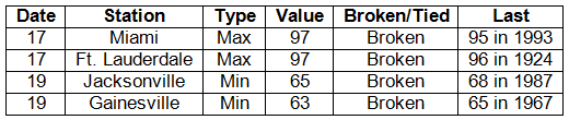
Average temperatures continued above normal in July. Average temperatures across the state were slightly above normal in July (Table 1). Two daily maximum records were broken during July. Both were 97° F at Miami and Ft. Lauderdale on the 17th (Table 2). Just two days later, daily minimum records were broken at Jacksonville (65° F) and Gainesville (63° F). Numerous daily record warm minimum temperatures were tied or broken during July. At West Palm Beach record warm minimum temperatures occurred on nine consecutive days at the end of the month. On the 28th and 29th, the minimum temperature at West Palm Beach (85° F) tied the all-time warmest minimum for any month there. Also, a minimum temperature of 84° F on the 28th tied the all-time warmest minimum for July at Ft. Lauderdale.
Table 1: July average temperatures and departures from normal (° F) for selected cities.
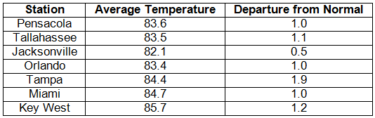
Table 2: Daily maximum and minimum temperature records (° F) broken or tied during July. (Compiled from NOAA, NWS.)
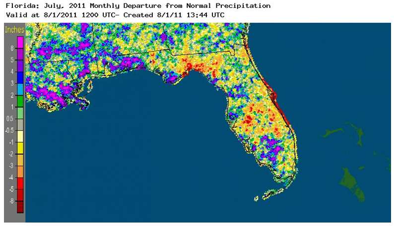
Rainfall totals varied relative to normal across the state during July. The monthly total at Tallahassee (4.28 in) was more than three and three-quarters inches below normal. In contrast, the monthly total at Orlando (10.62 in) was almost three and one half inches above normal (Table 3). Also, the monthly total at Pensacola (9.58 in) broke the record of 8.76 inches recorded in 2004. Several long-standing daily rainfall records were broken. The daily total at Vero Beach (4.09 in) on the 1st broke a record in existence since 1944 (Table 4). On the 7th, the daily total at Melbourne (2.80 in) broke a record in existence since 1957. Daily totals of 5.80 inches at Apalachicola and 3.13 inches at Ft. Myers on the 17th broke records in existence since 1964 and 1920, respectively. The daily total at Orlando (1.88 in) on the 22nd broke a record in existence since 1931. The impact of localized convective storms is evident in the departures from normal monthly rainfall for July (Figure 1). Well-above-normal rainfall occurred in the northwest and southwest, as well as other isolated locations. Well-below-normal rainfall fell in northern, south-central, and eastern coastal areas.
Table 3: July precipitation totals and departures from normal (inches) for selected cities.
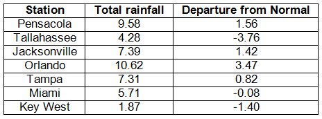
Table 4: Daily rainfall records broken during July.
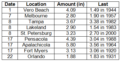
Figure 1: A graphical depiction of the monthly rainfall departure from normal (inches) for July is given in the figure below (courtesy of NOAA, NWS).
ENSO neutral phase continues during July. Sea surface temperatures in the equatorial Pacific Ocean were close to long-term average values during July, indicating a neutral phase of ENSO. However, atmospheric patterns continued to be as observed during La Niña. These ENSO conditions have little impact on weather across the state during summer.
Hazardous weather. A weak tornado caused roof and siding damage to four homes near Zephyrhills on the 7th. A severe thunderstorm produced wind gusts to 59 mph southwest of the Rotenberger Wildlife Management Area on the 1st. On the 15th trees were downed near Greenville, Madison, Hamilton, Jasper, and Lake City. Thunderstorm winds gusted to 60 mph at Estero, 59 mph at Charlotte County Airport, and 58 mph at Fort Myers on the 22nd. As a strong line of thunderstorms moved northeastward across the northeast corner of the state on the 25th, wind gusts downed trees and/or power lines near Starke, Palatka, Durbin, Palm Coast, Orange Park, and downtown Jacksonville.
Agricultural and other impacts. Substantial rain that fell during the middle of the month improved soil moisture for crops and pastures. Rain helped the growth of cotton and peanuts in the north, but plant sizes were still smaller by a few weeks of growth due to earlier dryness. Rapid growth of sugarcane was noted after rains in the south. However, the threat of pests and disease increased with higher moisture and high temperatures. Extreme drought conditions persisted in the northwest, north, and southeast parts of the state. Near-normal rains in recent weeks only produced short-term relief from the drought, and water restrictions are still in place in the southeast.